BLUE
AFwas.nws-bot.us

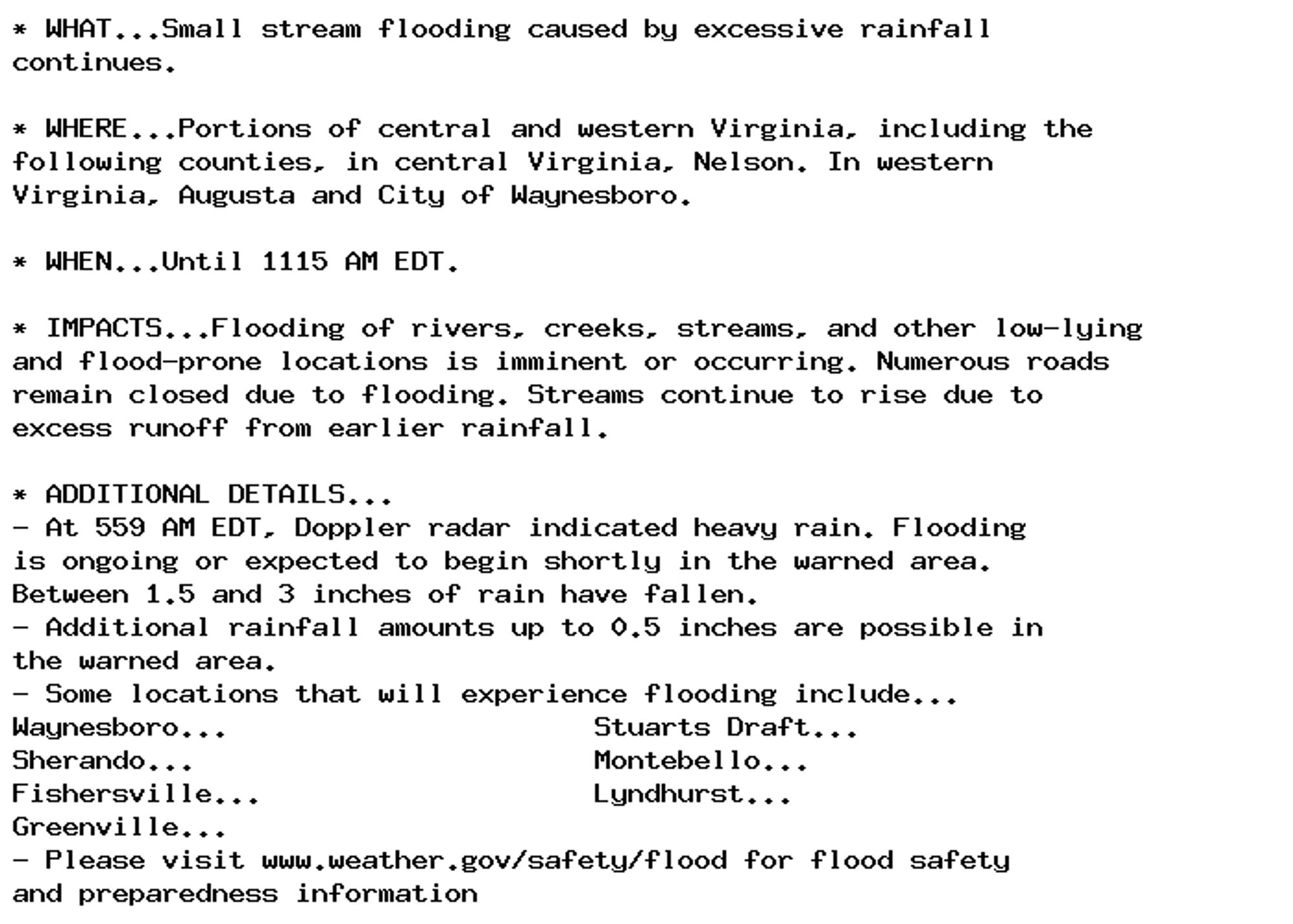
🚨 Flood Warning issued September 30 at 5:59AM EDT until September 30 at 11:15AM EDT by NWS Baltimore MD/Washington DC 🚨 Additional Details Here.

* WHAT...Small stream flooding caused by excessive rainfall
continues.

* WHERE...Portions of central and western Virginia, including the
following counties, in central Virginia, Nelson. In western
Virginia, Augusta and City of Waynesboro.

* WHEN...Until 1115 AM EDT.

* IMPACTS...Flooding of rivers, creeks, streams, and other low-lying
and flood-prone locations is imminent or occurring. Numerous roads
remain closed due to flooding. Streams continue to rise due to
excess runoff from earlier rainfall.

* ADDITIONAL DETAILS...
- At 559 AM EDT, Doppler radar indicated heavy rain. Flooding
is ongoing or expected to begin shortly in the warned area.
Between 1.5 and 3 inches of rain have fallen.
- Additional rainfall amounts up to 0.5 inches are possible in
the warned area.
- Some locations that will experience flooding include...
Waynesboro...                      Stuarts Draft...
Sherando...                        Montebello...
Fishersville...                    Lyndhurst...
Greenville...
- Please visit www.weather.gov/safety/flood for flood safety
and preparedness information
0
AFwas.nws-bot.us

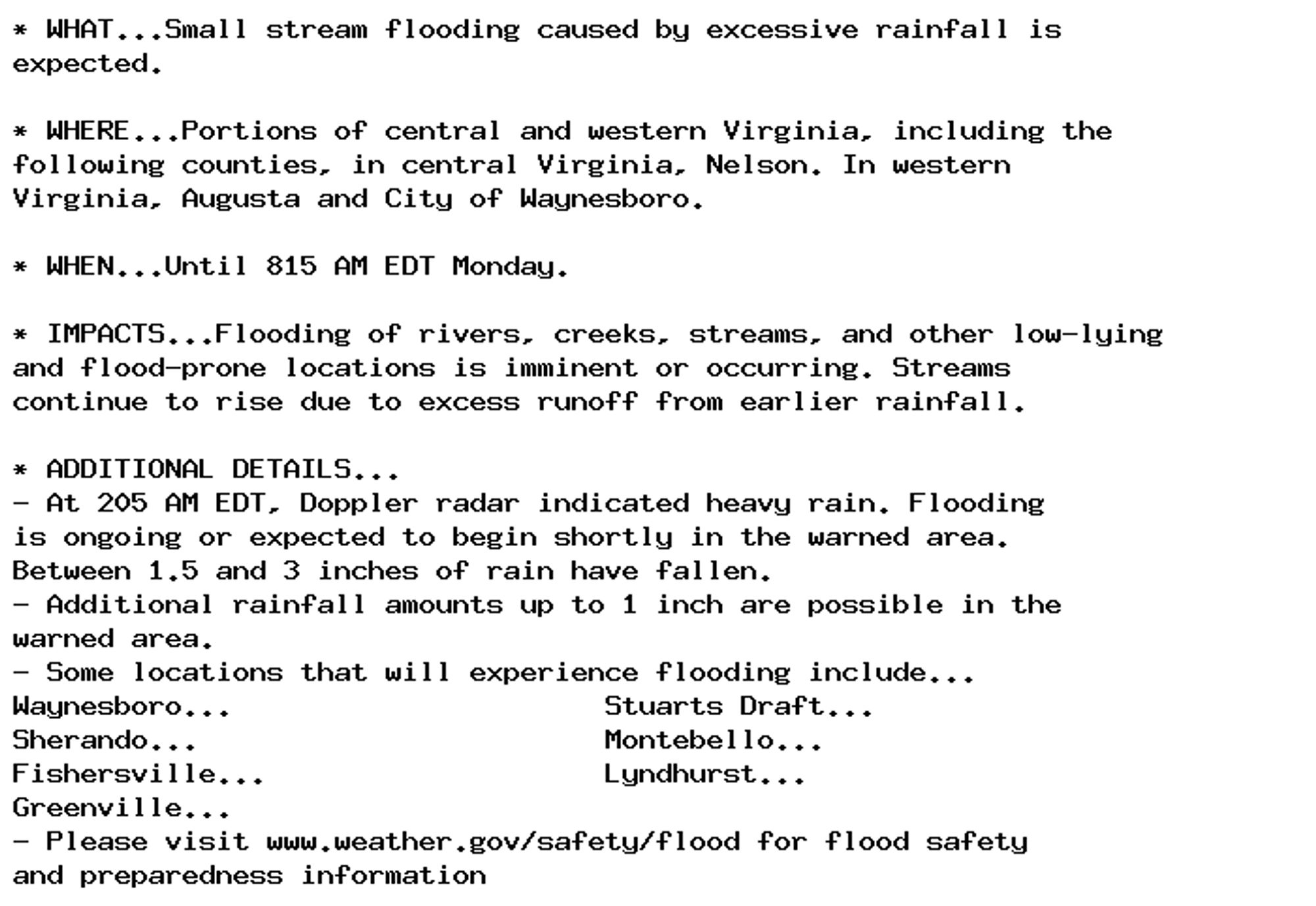
🚨 Flood Warning issued September 30 at 2:05AM EDT until September 30 at 8:15AM EDT by NWS Baltimore MD/Washington DC 🚨 Additional Details Here.

* WHAT...Small stream flooding caused by excessive rainfall is
expected.

* WHERE...Portions of central and western Virginia, including the
following counties, in central Virginia, Nelson. In western
Virginia, Augusta and City of Waynesboro.

* WHEN...Until 815 AM EDT Monday.

* IMPACTS...Flooding of rivers, creeks, streams, and other low-lying
and flood-prone locations is imminent or occurring. Streams
continue to rise due to excess runoff from earlier rainfall.

* ADDITIONAL DETAILS...
- At 205 AM EDT, Doppler radar indicated heavy rain. Flooding
is ongoing or expected to begin shortly in the warned area.
Between 1.5 and 3 inches of rain have fallen.
- Additional rainfall amounts up to 1 inch are possible in the
warned area.
- Some locations that will experience flooding include...
Waynesboro...                      Stuarts Draft...
Sherando...                        Montebello...
Fishersville...                    Lyndhurst...
Greenville...
- Please visit www.weather.gov/safety/flood for flood safety
and preparedness information
0
Jjaynereviews.bsky.social

Coffee time on a lazy Sunday afternoon. #coffee#newforest#merritts#lyndhurst#coffeetime

0
PBplanetbelfast.bsky.social

The #Frasier reboot just isn't working unfortunately. Poor scripts, pantomime style acting, no witty dramantatic tension, and very few laughs. Genuinely surprised it was renewed for season 2. A great example of why classic comedies should never come back

Nicholas Lyndhurst and Kelsey Grammar in Frasier
2
AFwas.nws-bot.us

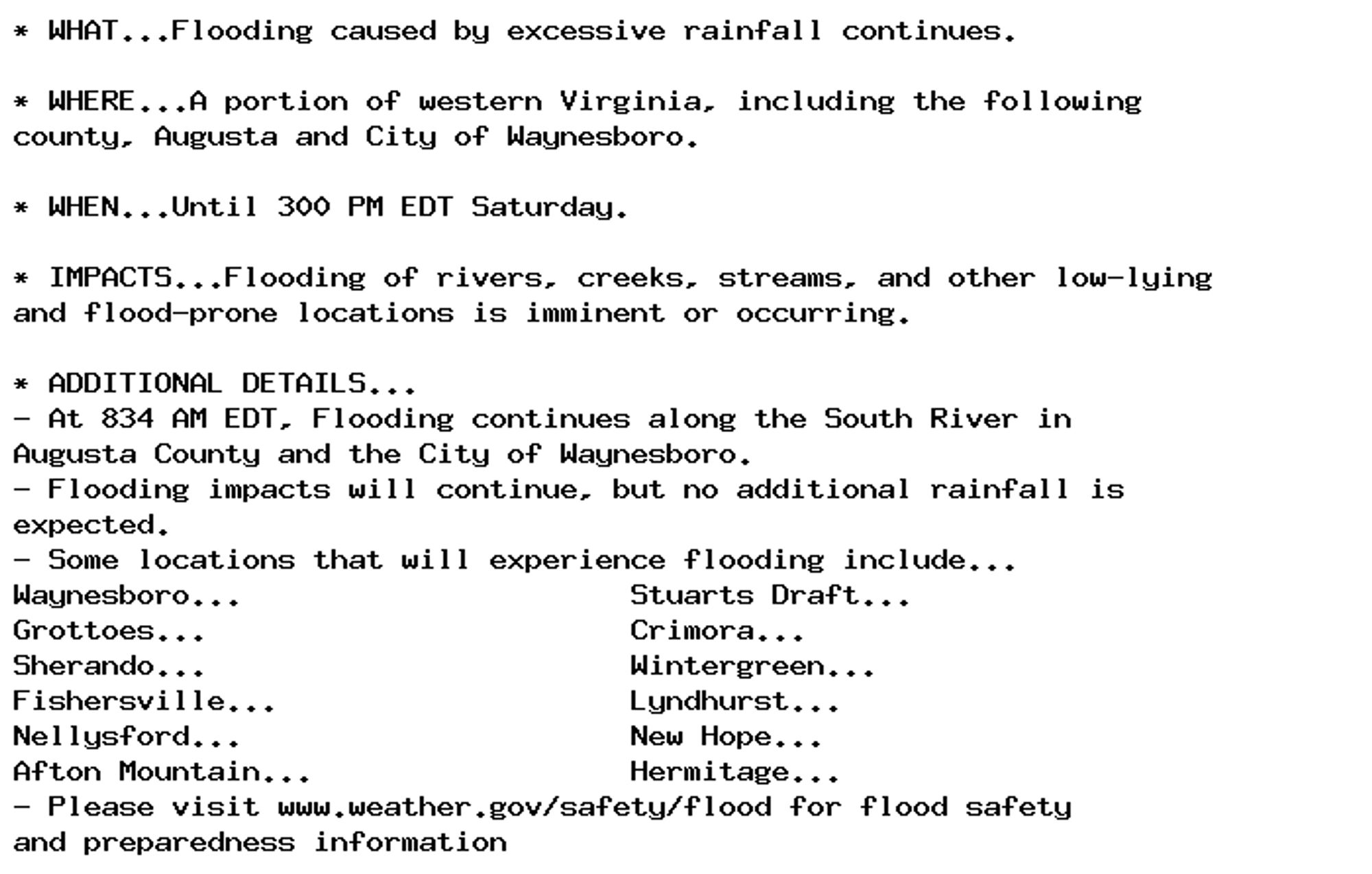
🚨 Flood Warning issued September 28 at 8:39AM EDT until September 28 at 3:00PM EDT by NWS Baltimore MD/Washington DC 🚨 Additional Details Here.

* WHAT...Flooding caused by excessive rainfall continues.

* WHERE...A portion of western Virginia, including the following
county, Augusta and City of Waynesboro.

* WHEN...Until 300 PM EDT Saturday.

* IMPACTS...Flooding of rivers, creeks, streams, and other low-lying
and flood-prone locations is imminent or occurring.

* ADDITIONAL DETAILS...
- At 834 AM EDT, Flooding continues along the South River in
Augusta County and the City of Waynesboro.
- Flooding impacts will continue, but no additional rainfall is
expected.
- Some locations that will experience flooding include...
Waynesboro...                      Stuarts Draft...
Grottoes...                        Crimora...
Sherando...                        Wintergreen...
Fishersville...                    Lyndhurst...
Nellysford...                      New Hope...
Afton Mountain...                  Hermitage...
- Please visit www.weather.gov/safety/flood for flood safety
and preparedness information
0
AFwas.nws-bot.us

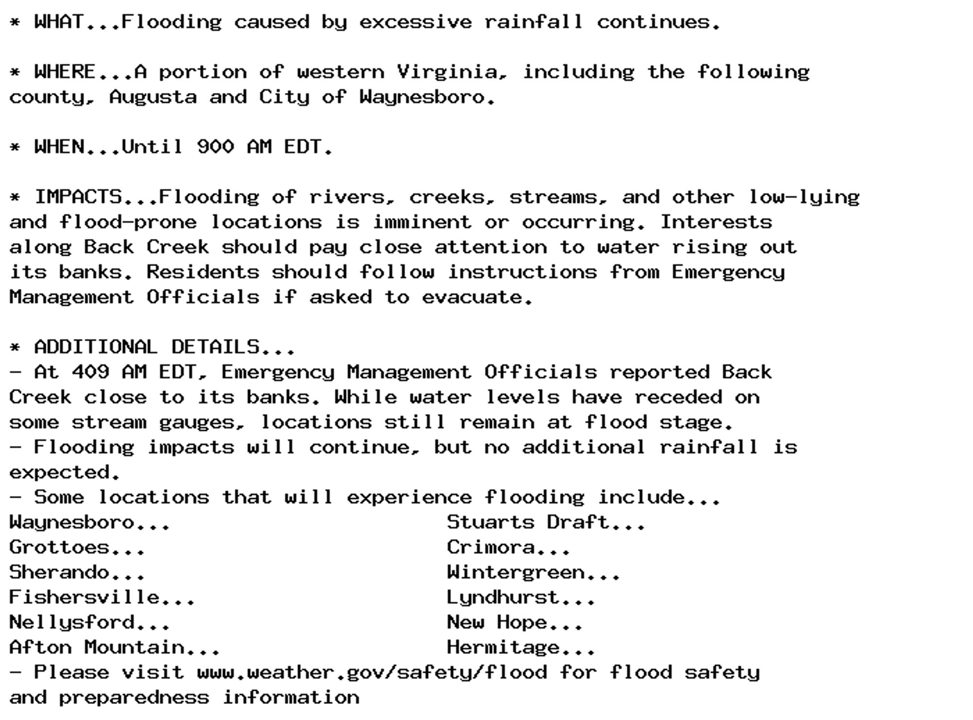
🚨 Flood Warning issued September 28 at 4:10AM EDT until September 28 at 9:00AM EDT by NWS Baltimore MD/Washington DC 🚨 Additional Details Here.

* WHAT...Flooding caused by excessive rainfall continues.

* WHERE...A portion of western Virginia, including the following
county, Augusta and City of Waynesboro.

* WHEN...Until 900 AM EDT.

* IMPACTS...Flooding of rivers, creeks, streams, and other low-lying
and flood-prone locations is imminent or occurring. Interests
along Back Creek should pay close attention to water rising out
its banks. Residents should follow instructions from Emergency
Management Officials if asked to evacuate.

* ADDITIONAL DETAILS...
- At 409 AM EDT, Emergency Management Officials reported Back
Creek close to its banks. While water levels have receded on
some stream gauges, locations still remain at flood stage.
- Flooding impacts will continue, but no additional rainfall is
expected.
- Some locations that will experience flooding include...
Waynesboro...                      Stuarts Draft...
Grottoes...                        Crimora...
Sherando...                        Wintergreen...
Fishersville...                    Lyndhurst...
Nellysford...                      New Hope...
Afton Mountain...                  Hermitage...
- Please visit www.weather.gov/safety/flood for flood safety
and preparedness information
0
BRbbcradio3bot.bsky.social

BBC Radio 3 Breakfast Now Playing Jóhann Jóhannsson, Jóhann Jóhannsson, Anthony Weeden & Air Lyndhurst String Orchestra Orphée: A Sparrow Alighted upon our Shoulder

0
AFwas.nws-bot.us

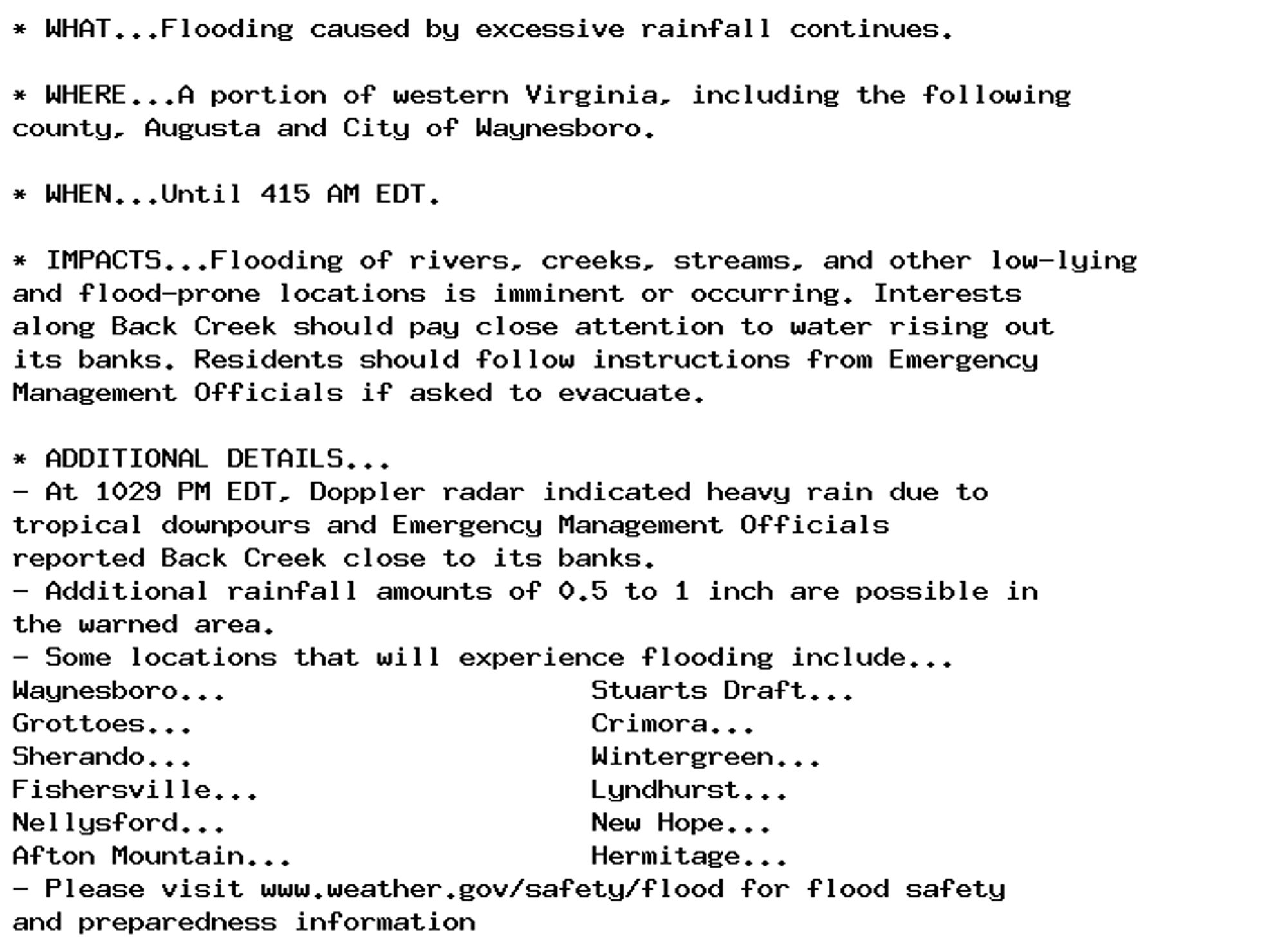
🚨 Flood Warning issued September 27 at 10:29PM EDT until September 28 at 4:15AM EDT by NWS Baltimore MD/Washington DC 🚨 Additional Details Here.

* WHAT...Flooding caused by excessive rainfall continues.

* WHERE...A portion of western Virginia, including the following
county, Augusta and City of Waynesboro.

* WHEN...Until 415 AM EDT.

* IMPACTS...Flooding of rivers, creeks, streams, and other low-lying
and flood-prone locations is imminent or occurring. Interests
along Back Creek should pay close attention to water rising out
its banks. Residents should follow instructions from Emergency
Management Officials if asked to evacuate.

* ADDITIONAL DETAILS...
- At 1029 PM EDT, Doppler radar indicated heavy rain due to
tropical downpours and Emergency Management Officials
reported Back Creek close to its banks.
- Additional rainfall amounts of 0.5 to 1 inch are possible in
the warned area.
- Some locations that will experience flooding include...
Waynesboro...                      Stuarts Draft...
Grottoes...                        Crimora...
Sherando...                        Wintergreen...
Fishersville...                    Lyndhurst...
Nellysford...                      New Hope...
Afton Mountain...                  Hermitage...
- Please visit www.weather.gov/safety/flood for flood safety
and preparedness information
0
Eshesays.bsky.social

Ready to add a little wag to your life? Say hello to, Helga, located in Lyndhurst, NJ. Learn more: https://www.petfinde...http://dlvr.it/TDm932

0
ALalittlefaith.bsky.social

Ready to add a little wag to your life? Say hello to, Helga, located in Lyndhurst, NJ. Learn more: https://www.petfinde...http://dlvr.it/TDm925

0