BLUE
TWpostingposter.bsky.social

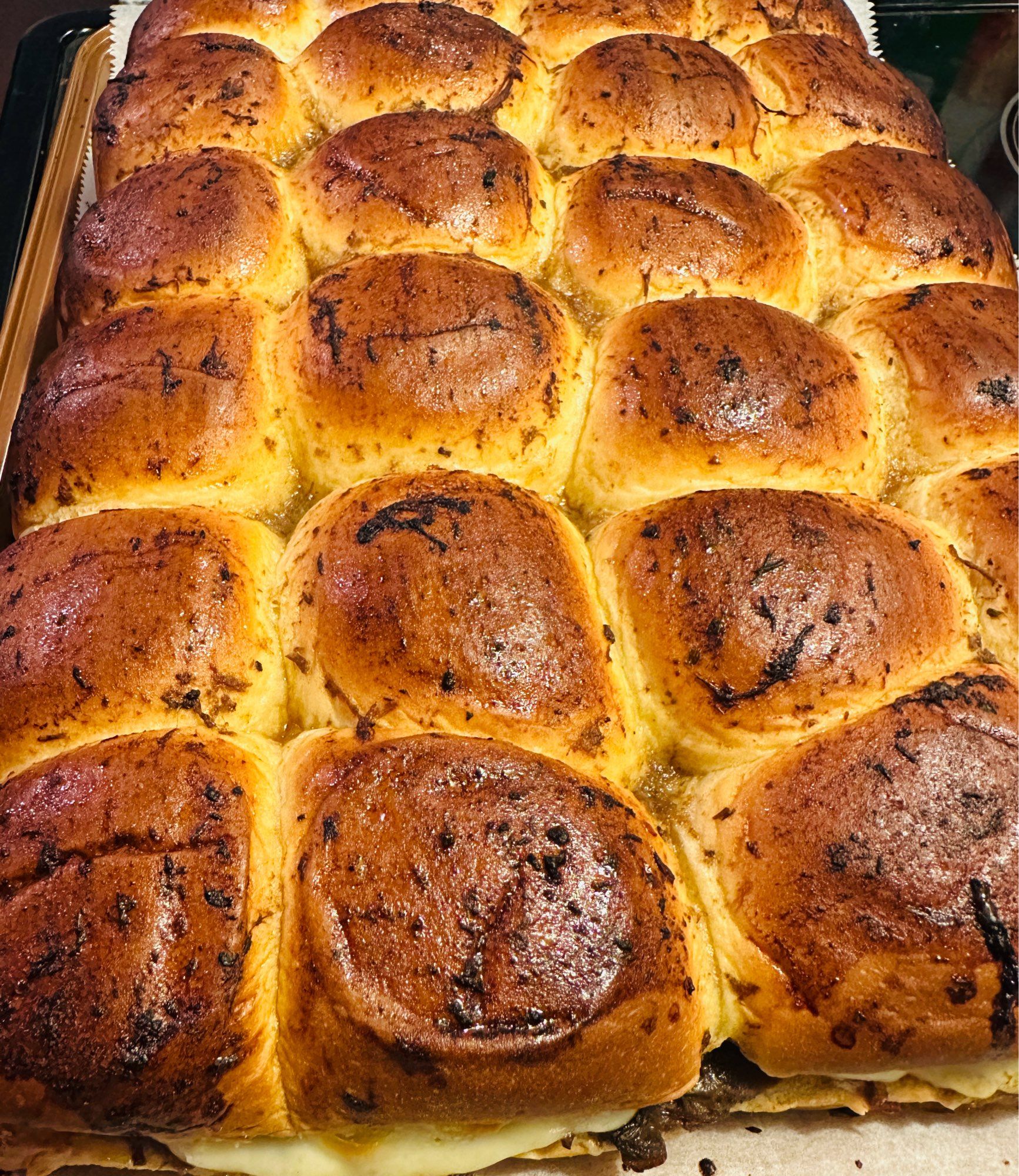
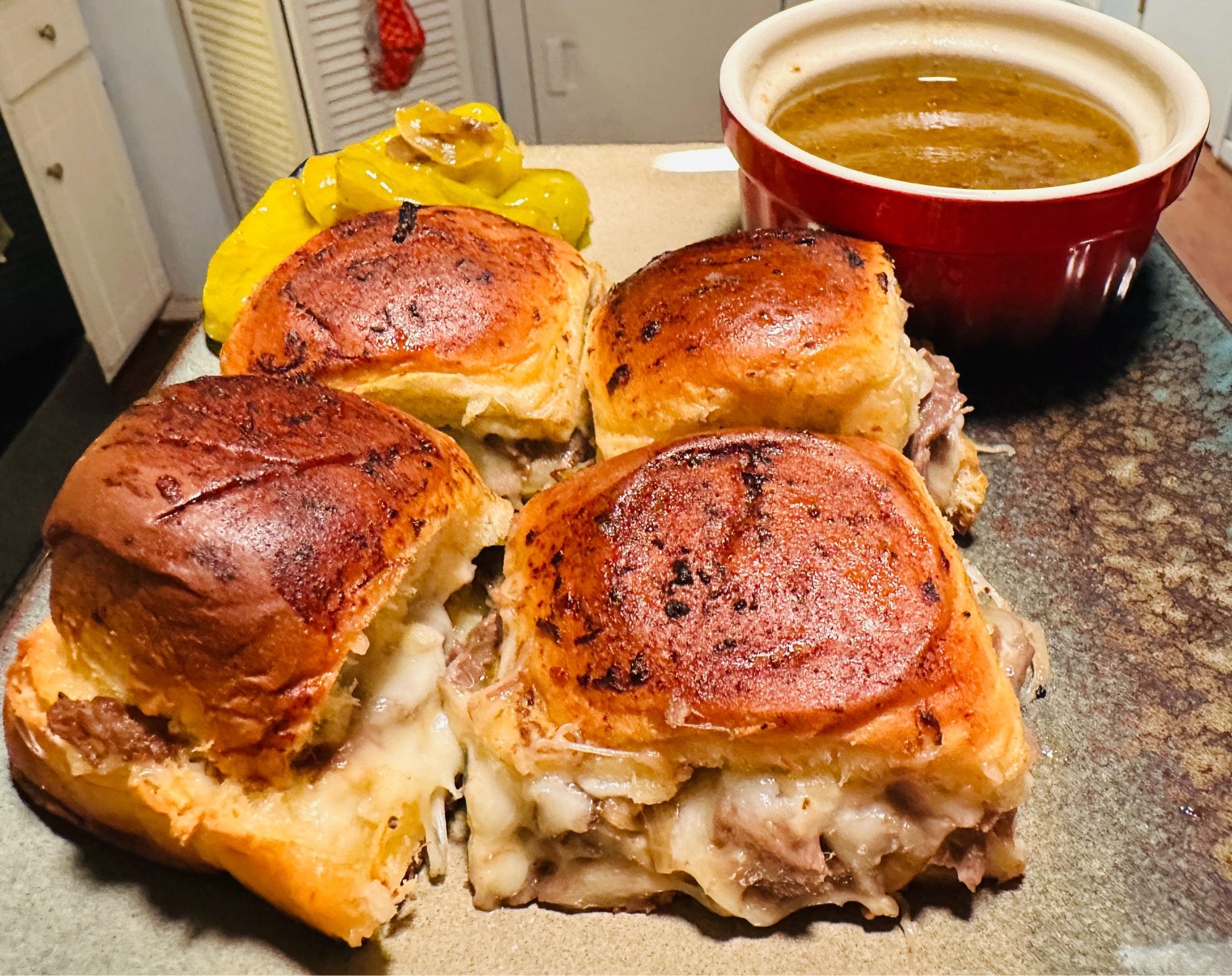
A Mississippi roast is a form of pot roast. The easiest way to make it is to take a big hunk of chuck, toss in a ranch dressing packet, a packet of brown gravy seasoning, and some pickled peppers along with a splash of juice and toss it all in your slow cooker until it's soft and shreddable.

2
CBcjones47.bsky.social

No real idea of what Mississippi roast is, but I'd try these.

2
Eerli.bsky.social

Yeah, the fight I had with Massachusetts especially... Special mentions to Pennsylvania, Louisiana and Mississippi...

0
SFspc-fire.nws-bot.us

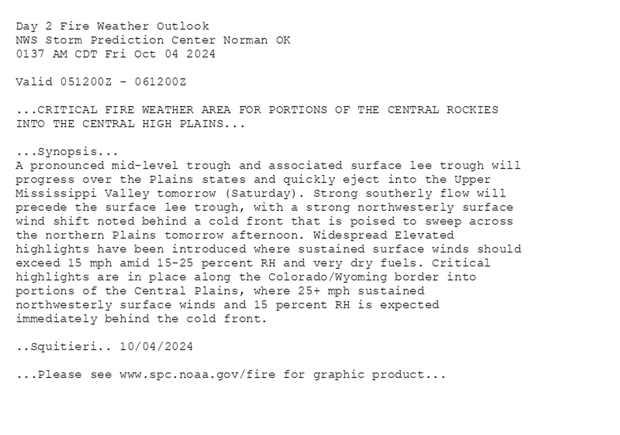
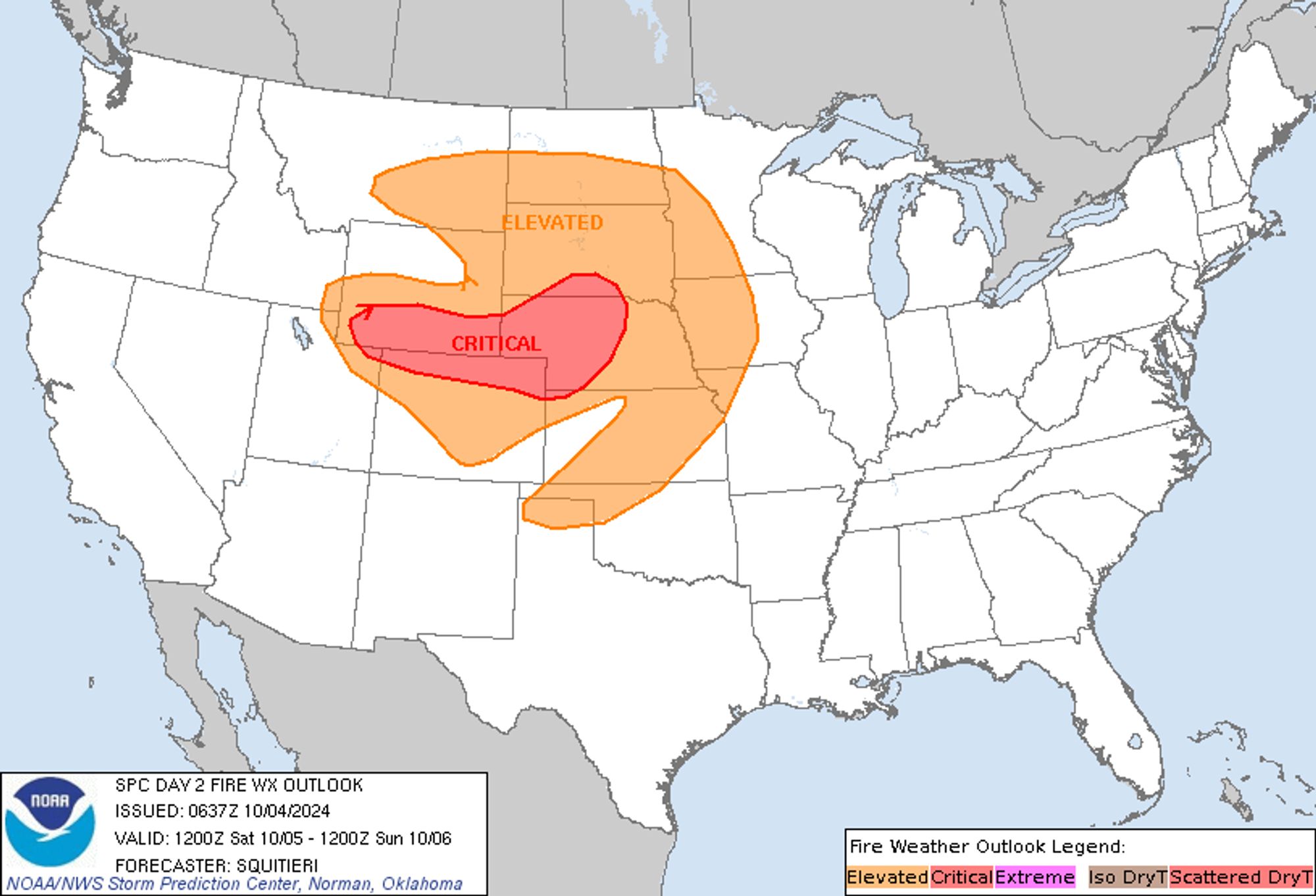
SPC Day 2 Fire Weather Outlook posted at Fri, 04 Oct 2024 06:39:28 +0000 🔥CRITICAL FIRE WEATHER AREA FOR PORTIONS OF THE CENTRAL ROCKIES INTO THE CENTRAL HIGH PLAINS🔥 Additional Details Here.


Day 2 Fire Weather Outlook  
NWS Storm Prediction Center Norman OK
0137 AM CDT Fri Oct 04 2024

Valid 051200Z - 061200Z

...CRITICAL FIRE WEATHER AREA FOR PORTIONS OF THE CENTRAL ROCKIES
INTO THE CENTRAL HIGH PLAINS...

...Synopsis...
A pronounced mid-level trough and associated surface lee trough will
progress over the Plains states and quickly eject into the Upper
Mississippi Valley tomorrow (Saturday). Strong southerly flow will
precede the surface lee trough, with a strong northwesterly surface
wind shift noted behind a cold front that is poised to sweep across
the northern Plains tomorrow afternoon. Widespread Elevated
highlights have been introduced where sustained surface winds should
exceed 15 mph amid 15-25 percent RH and very dry fuels. Critical
highlights are in place along the Colorado/Wyoming border into
portions of the Central Plains, where 25+ mph sustained
northwesterly surface winds and 15 percent RH is expected
immediately behind the cold front.

..Squitieri.. 10/04/2024

...Please see www.spc.noaa.gov/fire for graphic product...
Day 2 Fire Weather Outlook Image
0
STsethhahne.bsky.social

...but where Portis had Jimmy ferry the reader from person to person (always a safe haven, Jimmy!), Melville deposits us on an actual ferry, a riverboat on the Mississippi, and bounces us frenetically from passenger to passenger, no relation...

1
STspc-storms.nws-bot.us

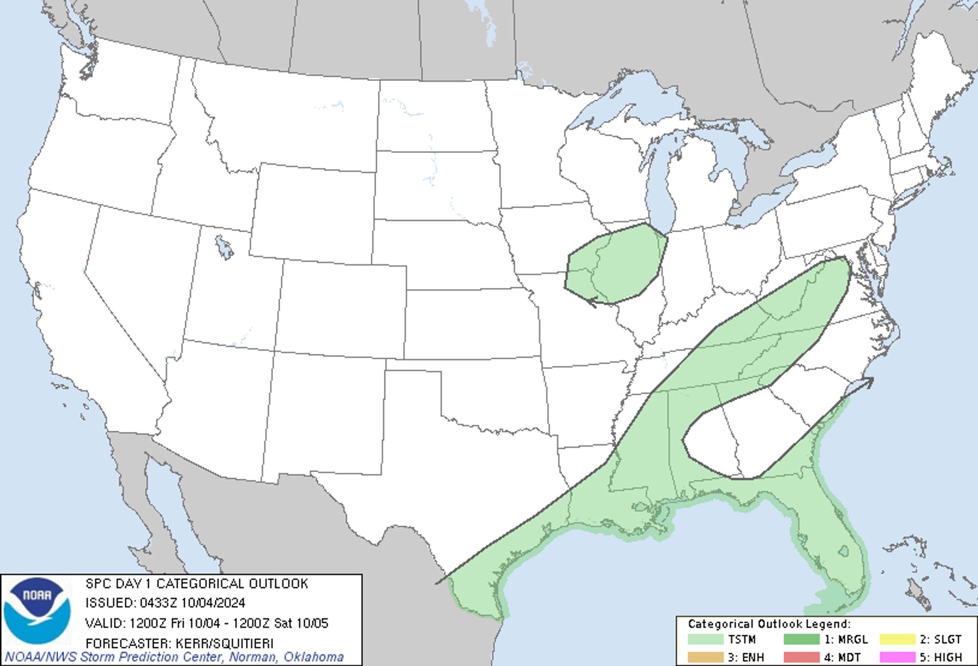
SPC Oct 4, 2024 0600 UTC Day 1 Convective Outlook ⛈️NO SEVERE THUNDERSTORM AREAS FORECAST🌪️ Additional Details Here.


Day 1 Convective Outlook  
NWS Storm Prediction Center Norman OK
1133 PM CDT Thu Oct 03 2024

Valid 041200Z - 051200Z

...NO SEVERE THUNDERSTORM AREAS FORECAST...

...SUMMARY...
The risk for severe thunderstorms appears negligible across the U.S.
today through tonight.

...Discussion...
Seasonably high moisture content will generally remain confined to
where the low-level easterlies prevail, across the southwestern
Atlantic through the Gulf Basin during this period.  The boundary
layer does remain relatively moist across much of the southeastern
U.S., but this region, and most areas east of the Mississippi
Valley, are forecast to remain under the influence of surface high
pressure.  Still, weak to modest destabilization and orographic
forcing with daytime heating may contribute to some thunderstorm
development today across parts of the upper Tennessee Valley and
Cumberland Plateau into the Blue Ridge.  Otherwise, higher
thunderstorm probabilities likely will remain focused across
southern portions of the Florida Peninsula and immediate
northwestern through north central Gulf coastal areas.  An area of
thunderstorm development, largely aided by ascent associated with
lower/mid-tropospheric warm advection, may be ongoing at 12Z this
morning across parts of southeastern Iowa and adjacent northeastern
Missouri/west central Illinois.  But this appears likely to
gradually diminish while slowly spreading southeastward across west
central/central Illinois through mid to late morning.

The stronger westerlies remain confined to the northern
mid-latitudes, with one rather vigorous embedded short wave trough
forecast to rapidly accelerate inland of the Pacific Northwest coast
and across the northern Rockies by 12Z Saturday.  Models indicate
that this will be accompanied by cyclogenesis to the lee of the
Canadian Rockies, and strong pre- and post-frontal
lower/mid-tropospheric wind fields across the northern U.S. Rockies
into Great Plains.  Despite rather dry initial conditions, strong
mid/upper forcing for ascent may contribute to at least weak
high-based convection, near or above/to the cool side of the surging
cold front.  While it is possible that this could coincide with
strong/gusty surface conditions, forecast soundings suggest minimal
potential for these gusts to be related to moist convective
processes, and it still appears unlikely that this convection will
be accompanied by much, if any, lightning.

..Kerr/Squitieri.. 10/04/2024
Day 1 Outlook Image
0
JRjenni4iowa.bsky.social

I thought Memphis was West Tennessee, or is Memphis part of Mississippi?

1

#CO2#CCS#Satartia Mississippi Accident Investigation

0
BCbettycjung.bsky.social

in terms of thinking about what it means to be healthy and how to protect themselves, and that goes beyond a person’s sexual health.” The latest CDC data from 2022 shows Mississippi has the highest teen birth rate in the country.

1