BLUE
AFunr.nws-bot.us

Freeze Warning issued September 30 at 9:39PM MDT until October 1 at 8:00AM MDT by NWS Rapid City SD Additional Details Here.

* WHAT...Sub-freezing temperatures as low as 30 expected.

* WHERE...Portions of northwestern and southwestern South Dakota and
northeast Wyoming.

* WHEN...Until 8 AM MDT Tuesday.

* IMPACTS...Frost and freeze conditions could kill crops, other
sensitive vegetation and possibly damage unprotected outdoor
plumbing.
0
AFunr.nws-bot.us

🚨 Fire Weather Watch issued September 30 at 9:41PM MDT until October 1 at 6:00PM MDT by NWS Rapid City SD 🚨 Additional Details Here.

...ELEVATED TO CRITICAL FIRE WEATHER CONDITIONS EXPECTED AGAIN
ACROSS NORTHEAST WYOMING AND WESTERN SOUTH DAKOTA TUESDAY
AFTERNOON...

.South to southwest return flow develops Tuesday with gusts of 25
mph or higher through the afternoon. These increased winds along
with afternoon minimum relative humidity around 10 to 20 percent
may result in critical fire weather conditions again Tuesday.

Relative humidity recovery Tuesday night will be poor (<35% over
the west) ahead of a cold front that moves through Wednesday, so
elevated fire weather conditions expected. If winds are a bit
stronger Wednesday, fire weather headlines may need to be
extended into Wednesday.

* AFFECTED AREA...Fire Weather Zones 314 Northern Campbell, 315
Southern Campbell, 316 Crook County Plains, 317 Weston County
Plains, 318 Wyoming Black Hills, 319 Northern Black Hills, 320
Central Black Hills, 321 Southern Black Hills, 322 Fall River
County Area, 323 Northern Foot Hills, 324 Eastern Foot Hills,
325 Custer County Plains, 326 Pine Ridge Area, 327 Butte
County Area, 328 Perkins County, 329 West Central Plains, 330
Ziebach County, 331 Haakon County Area, 332 Badlands Area, 333
Bennett County Area and 334 Mellette and Todd Counties.

* WINDS...South 10 to 20 mph with gusts up to 35 mph.

* RELATIVE HUMIDITY...As low as 10 percent.

* IMPACTS...The combination of gusty winds and low relative
humidity will produce critical fire weather conditions.
0

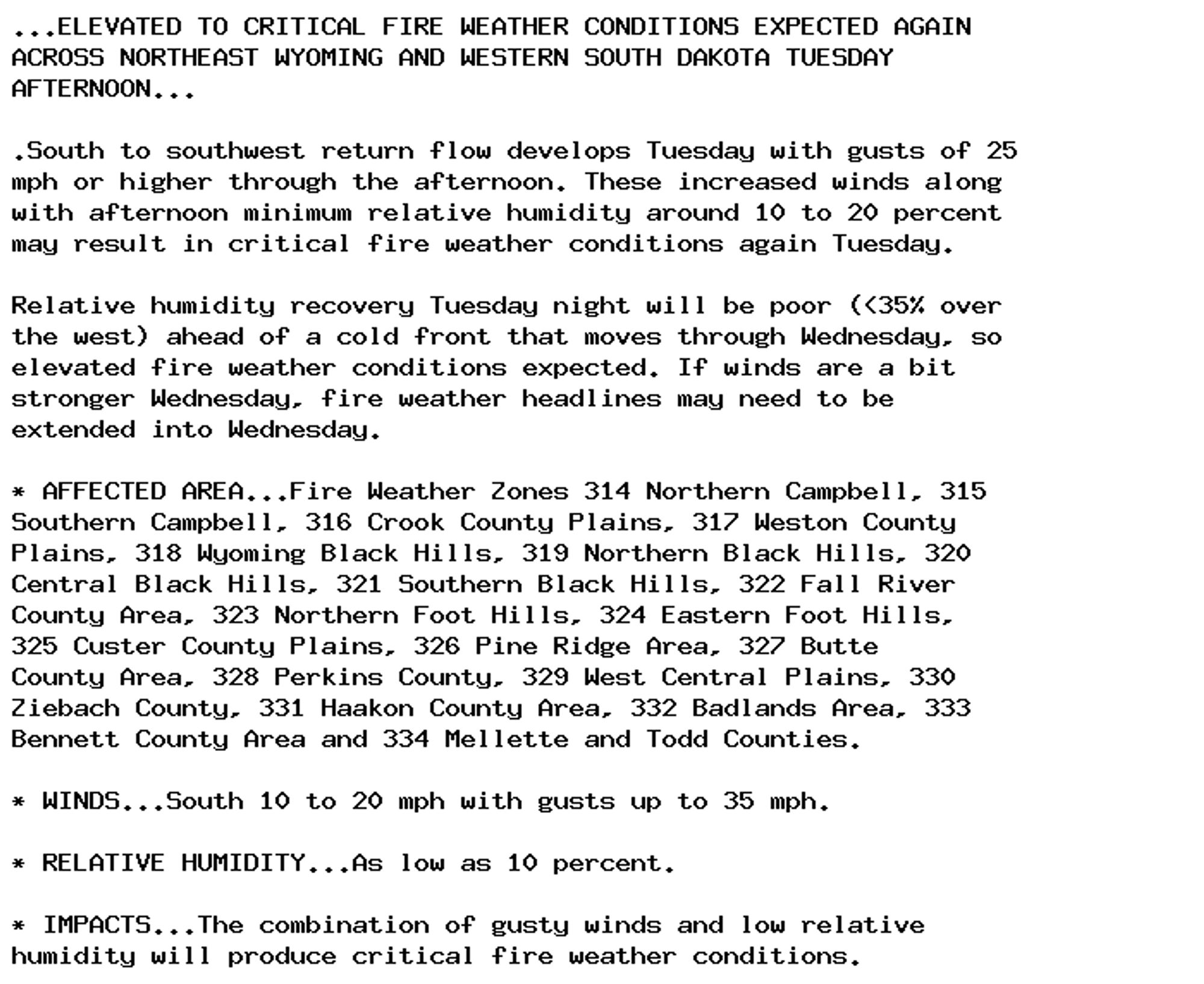
NEW WEATHER ADVISORY: Fire Weather Watch ...ELEVATED TO CRITICAL FIRE WEATHER CONDITIONS EXPECTED AGAIN ACROSS NORTHEAST WYOMING AND WESTERN SOUTH DAKOTA TUESDAY AFTERNOON... .South to southwest return flow develops Tuesday with gusts of 25 mph or... See more: watchedsky.social/app/alerts/...

0

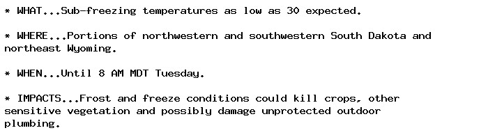
NEW WEATHER ADVISORY: Freeze Warning * WHAT...Sub-freezing temperatures as low as 30 expected. * WHERE...Portions of northwestern and southwestern South Dakota and northeast Wyoming. * WHEN...Until 8 AM MDT Tuesday. * IMPACTS...Frost and freeze... See more: watchedsky.social/app/alerts/...

0
AFsfo.nws-bot.us

🚨 Fire Weather Watch issued September 30 at 8:27PM PDT until October 3 at 8:00PM PDT by NWS San Francisco CA 🚨 Additional Details Here.

...ELEVATED FIRE WEATHER CONCERNS FOR PORTIONS OF INTERIOR
MONTEREY COUNTY WEDNESDAY AND THURSDAY WITH DRY AND GUSTY
OFFSHORE WINDS EXPECTED TO DEVELOP...

.Gusty north-northeast winds are expected to develop Wednesday
and last into Thursday across interior portions of Monterey
county, including the Santa Lucia, Los Padres National Forest,
and the southern Salinas Valley. A dry airmass already in place
will be subject to these gusty offshore winds of 20-30 mph,
promoting further drying with daytime minimum humidity as low as
8%. Poor overnight recovery will also be a factor, with maximum
RH in the 15-30% range each Wednesday and Thursday mornings. The
strongest winds are expected to be Wednesday evening overnight
into Thursday morning.

* AFFECTED AREA...Fire Weather Zone 516 Southern Salinas
Valley/Arroyo Seco and Lake San Antonio and Fire Weather Zone
517 Santa Lucia Mountains and Los Padres National Forest.

* TIMING...6 AM Wednesday until 8 PM Thursday.

* WINDS...North 10 to 20 mph with gusts up to 30 mph.

* RELATIVE HUMIDITY...As low as 8 percent.

* TEMPERATURES...Up to 106.

* LIGHTNING...None.

* IMPACTS...The combination of gusty winds and low humidity can
cause fire to rapidly grow in size and intensity. Outdoor
burning is not recommended.
0

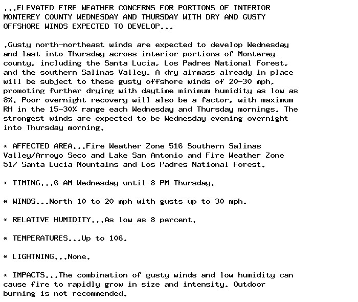
NEW WEATHER ADVISORY: Fire Weather Watch ...ELEVATED FIRE WEATHER CONCERNS FOR PORTIONS OF INTERIOR MONTEREY COUNTY WEDNESDAY AND THURSDAY WITH DRY AND GUSTY OFFSHORE WINDS EXPECTED TO DEVELOP... .Gusty north-northeast winds are expected to develop... See more: watchedsky.social/app/alerts/...

0
AFmhx.nws-bot.us

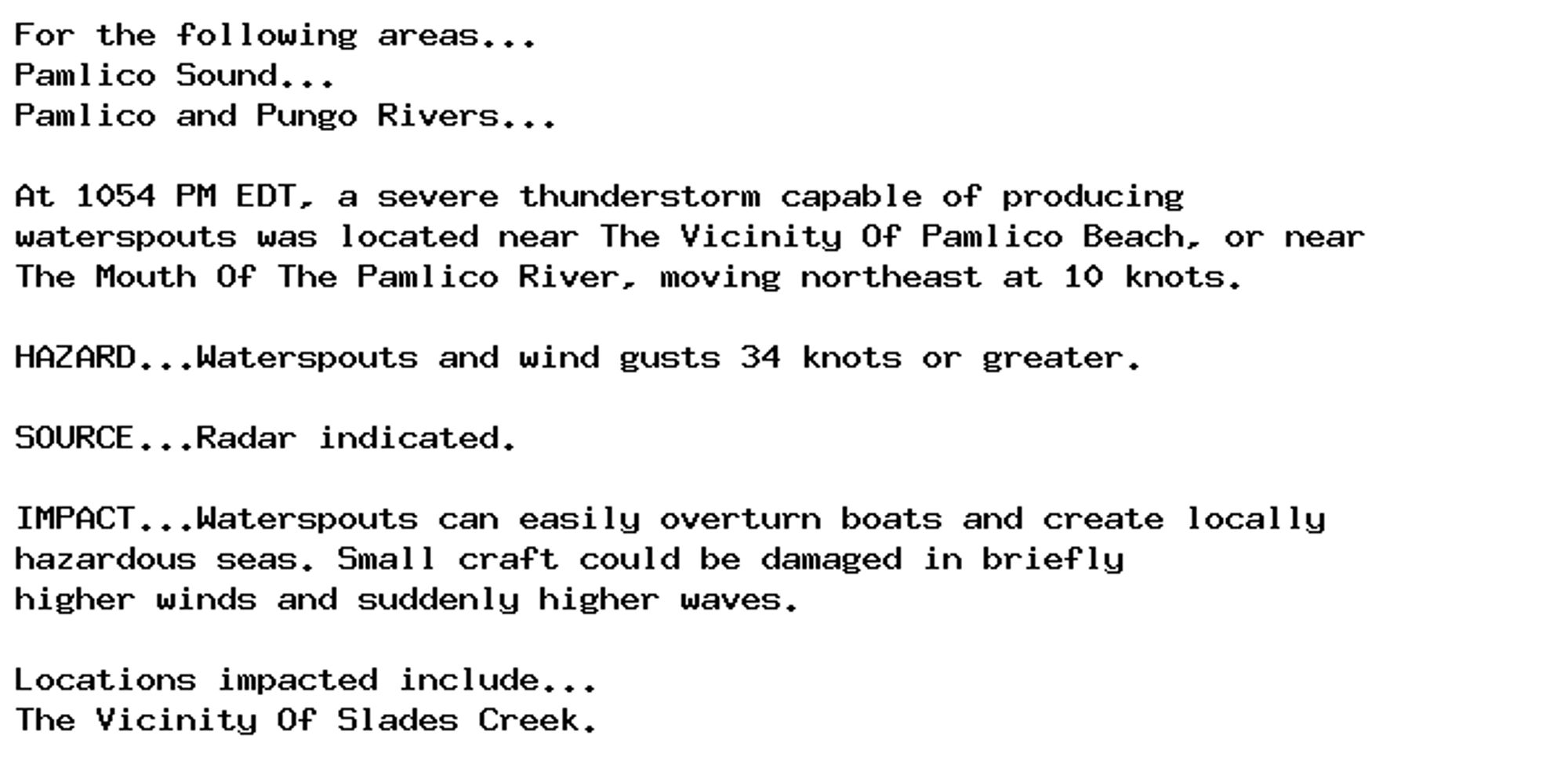
🚨 Special Marine Warning issued September 30 at 10:54PM EDT until September 30 at 11:15PM EDT by NWS Newport/Morehead City NC 🚨 Additional Details Here.

For the following areas...
Pamlico Sound...
Pamlico and Pungo Rivers...

At 1054 PM EDT, a severe thunderstorm capable of producing
waterspouts was located near The Vicinity Of Pamlico Beach, or near
The Mouth Of The Pamlico River, moving northeast at 10 knots.

HAZARD...Waterspouts and wind gusts 34 knots or greater.

SOURCE...Radar indicated.

IMPACT...Waterspouts can easily overturn boats and create locally
hazardous seas. Small craft could be damaged in briefly
higher winds and suddenly higher waves.

Locations impacted include...
The Vicinity Of Slades Creek.
0
AForf.nws-bot.us

🚨 Flood Warning issued September 30 at 10:56PM EDT until October 1 at 4:00AM EDT by NWS Wakefield VA 🚨 Additional Details Here.

* WHAT...Flooding caused by excessive rainfall is expected.

* WHERE...A portion of northeast North Carolina, including the
following county, Bertie.

* WHEN...Until 400 AM EDT.

* IMPACTS...Flooding of rivers, creeks, streams, and other low-lying
and flood-prone locations is imminent or occurring.

* ADDITIONAL DETAILS...
- At 1056 PM EDT, local law enforcement reported high water on
a few back roads in the county. Flooding is already
occurring. Between 2 and 3.5 inches of rain have fallen.
- Some locations that will experience flooding include...
Windsor, Lewiston Woodville, Quitsna and Republican.
- http://www.weather.gov/safety/flood
0

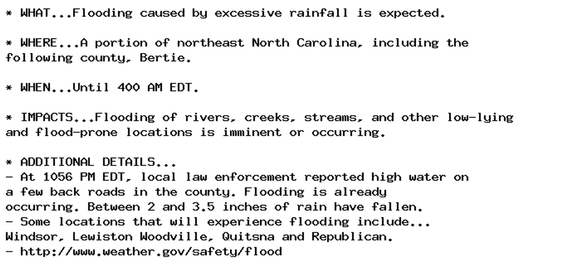
NEW WEATHER ADVISORY: Flood Warning * WHAT...Flooding caused by excessive rainfall is expected. * WHERE...A portion of northeast North Carolina, including the following county, Bertie. * WHEN...Until 400 AM EDT. * IMPACTS...Flooding of rivers,... See more: watchedsky.social/app/alerts/...

0
AFmhx.nws-bot.us

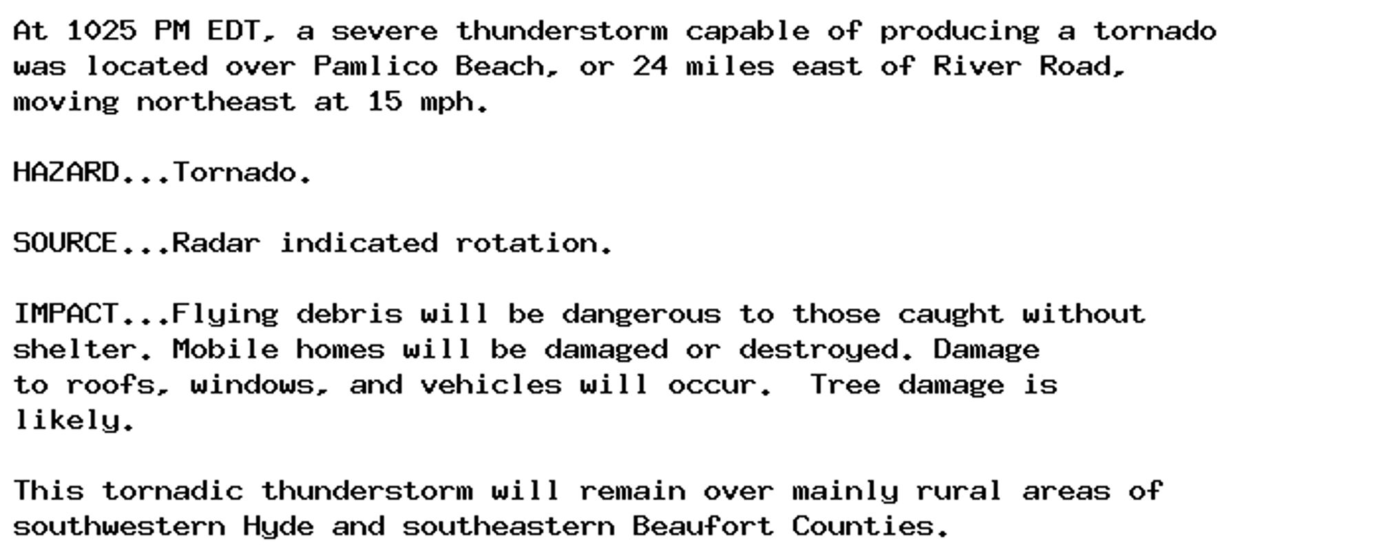
🚨🚨🚨 Tornado Warning issued September 30 at 10:25PM EDT until September 30 at 10:45PM EDT by NWS Newport/Morehead City NC 🚨🚨🚨 Additional Details Here.

At 1025 PM EDT, a severe thunderstorm capable of producing a tornado
was located over Pamlico Beach, or 24 miles east of River Road,
moving northeast at 15 mph.

HAZARD...Tornado.

SOURCE...Radar indicated rotation.

IMPACT...Flying debris will be dangerous to those caught without
shelter. Mobile homes will be damaged or destroyed. Damage
to roofs, windows, and vehicles will occur.  Tree damage is
likely.

This tornadic thunderstorm will remain over mainly rural areas of
southwestern Hyde and southeastern Beaufort Counties.
0