BLUE
CScostasamaras.bsky.social

This varies by region of course, with the Northeast having many more homes without a parking spot. But the mountain west and southwest have a lot of homes with garages and folks there drive more miles.

1

NEW WEATHER ADVISORY: Flood Advisory The Flood Advisory has expired for portions of northeast North Carolina, including the following area, Northampton and southeast Virginia, including the following areas, Greensville, Southampton and Sussex. The... See more: watchedsky.social/app/alerts/...

0
JGmodestholdings.com

If you're a Johnson County resident you can grab free PCR tests at the HHS building, northeast stairwell. They do take a day or two, but if you can hand deliver them to the State Hygienic Lab in Coralville, it's quicker.

0
AFrdu.nws-bot.us

Special Weather Statement issued September 30 at 8:24PM EDT by NWS Raleigh NC Additional Details Here.

At 822 PM EDT, Doppler radar was tracking gusty showers along a line
extending from near Fuquay-Varina to 6 miles northeast of Pope AFB to
Raeford. Movement was east at 15 mph.

HAZARD...Wind gusts up to 40 mph.

SOURCE...Radar indicated.

IMPACT...Gusty winds could knock down tree limbs and blow around
unsecured objects.

Locations impacted include...
Fayetteville, Raeford, Lillington, Fort Liberty, Garner,
Fuquay-Varina, Dunn, Angier, Benson, and Godwin.
0
NWskeetbot.watchedsky.social

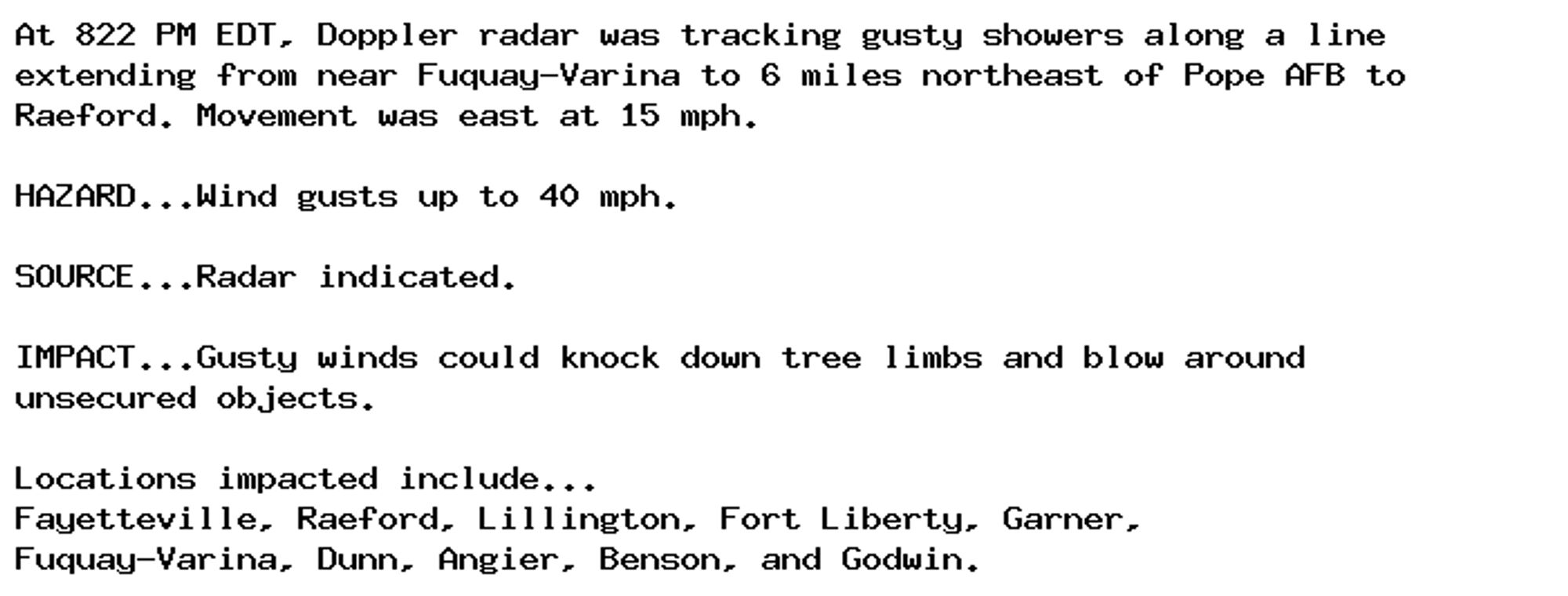
NEW WEATHER ADVISORY: Special Weather Statement At 822 PM EDT, Doppler radar was tracking gusty showers along a line extending from near Fuquay-Varina to 6 miles northeast of Pope AFB to Raeford. Movement was east at 15 mph. HAZARD...Wind gusts up to... See more: watchedsky.social/app/alerts/...

0
AFacv.nws-bot.us

🚨 Red Flag Warning issued September 30 at 5:06PM PDT until October 1 at 11:00AM PDT by NWS Eureka CA 🚨 Additional Details Here.

...Strong gusty east to northeast winds with low afternoon
humidity and poor overnight humidity recoveries will result in
critical fire weather conditions this evening through Tuesday
morning...

* AFFECTED AREA...Fire weather zone 203.Fire weather zone 204.

* WIND...East to northeast winds of 15 to 25 mph with gusts up
to 40 mph in the evening and morning across local ridgetop.

* HUMIDITY...Poor overnight relative humidity recovery from 25
to 35 percent followed by dryer daytime values from 15 to 25
percent.

* IMPACTS...any fires that develop will likely spread rapidly.
Outdoor burning is not recommended.
0
NWskeetbot.watchedsky.social

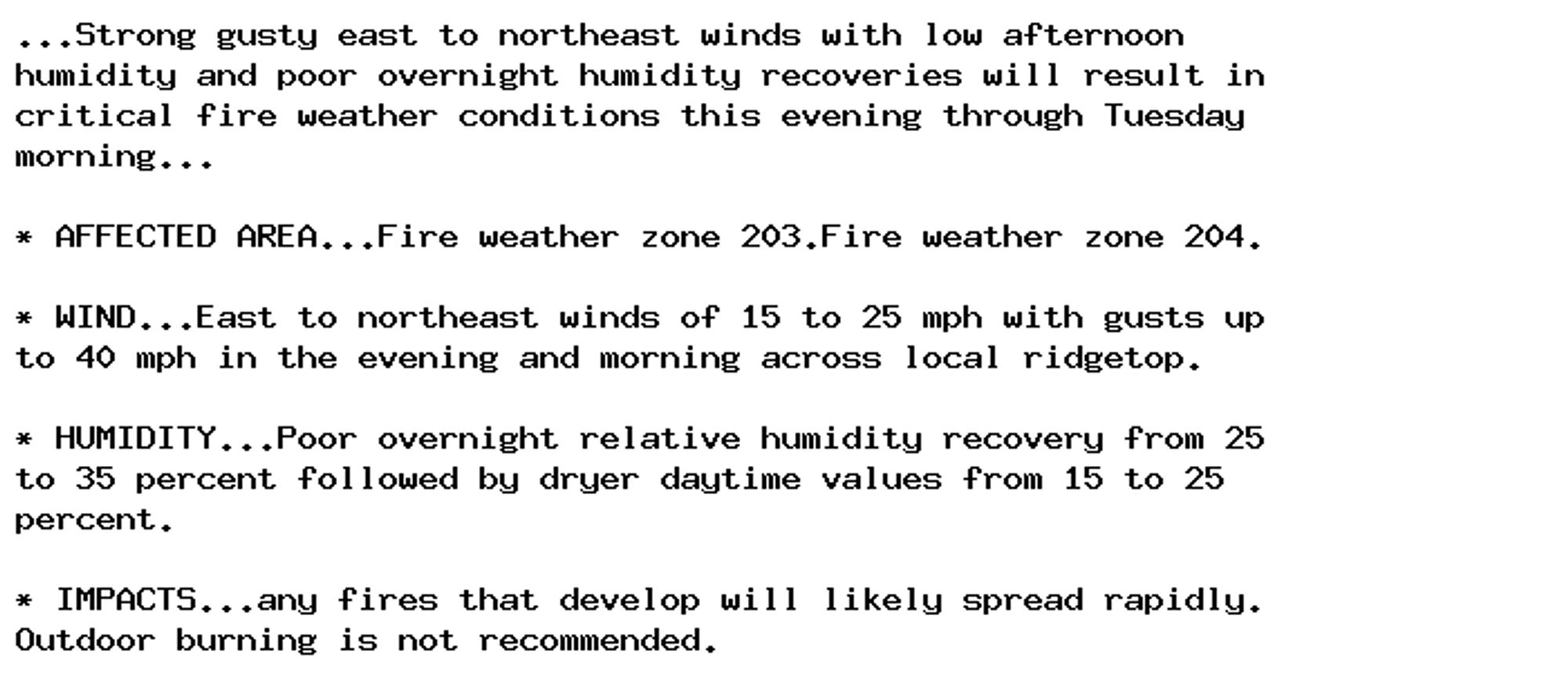
NEW WEATHER ADVISORY: Red Flag Warning ...Strong gusty east to northeast winds with low afternoon humidity and poor overnight humidity recoveries will result in critical fire weather conditions this evening through Tuesday morning... * AFFECTED... See more: watchedsky.social/app/alerts/...

0
Eesiode.bsky.social

📃Scientific paper: Assessment of bacterial profile, antimicrobial susceptibility status, and associated factors of isolates among hospitalized patients at Dessie Comprehensive Specialized Hospital, Northeast Ethiopia ➡️ Continued on ES/IODE

0
AFfgf.nws-bot.us

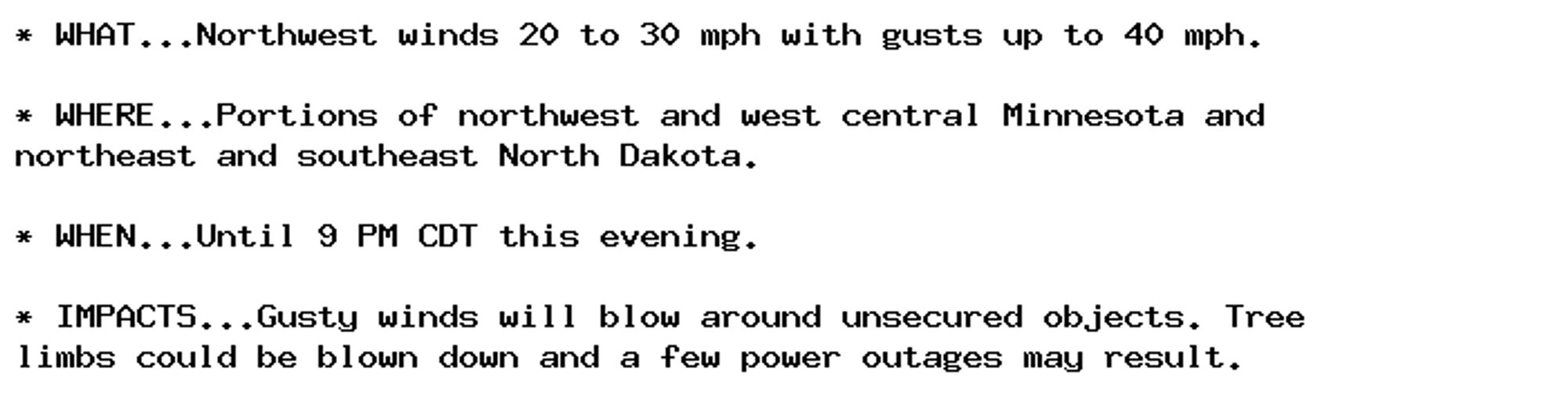
Wind Advisory issued September 30 at 6:35PM CDT until September 30 at 9:00PM CDT by NWS Grand Forks ND Additional Details Here.

* WHAT...Northwest winds 20 to 30 mph with gusts up to 40 mph.

* WHERE...Portions of northwest and west central Minnesota and
northeast and southeast North Dakota.

* WHEN...Until 9 PM CDT this evening.

* IMPACTS...Gusty winds will blow around unsecured objects. Tree
limbs could be blown down and a few power outages may result.
0
TFtonyfisher.bsky.social

Proof of god's love. Signed, The Northeast

1