BLUE
AFwas.nws-bot.us

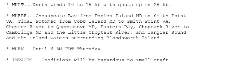
Small Craft Advisory issued October 17 at 1:29AM EDT until October 18 at 6:00AM EDT by NWS Baltimore MD/Washington DC Additional Details Here.

* WHAT...North winds 10 to 20 kt with gusts up to 25 kt.

* WHERE...Chesapeake Bay main channel north of Smith Point VA,
Tidal Potomac from Cobb Island MD to Smith Point VA, Chester
River to Queenstown MD, Eastern Bay, Choptank River to
Cambridge MD and the Little Choptank River, and Tangier Sound
and the inland waters surrounding Bloodsworth Island.

* WHEN...Until 6 AM EDT Friday.

* IMPACTS...Conditions will be hazardous to small craft.
* WHAT...North winds 10 to 15 kt with gusts up to 20 kt expected.

* WHERE...Tidal Potomac River from Key Bridge to Cobb Island MD,
Patapsco River including Baltimore Harbor, and Patuxent River
to Broomes Island MD.

* WHEN...From 10 AM this morning to 5 PM EDT this afternoon.

* IMPACTS...Conditions will be hazardous to small craft.
0
NWskeetbot.watchedsky.social

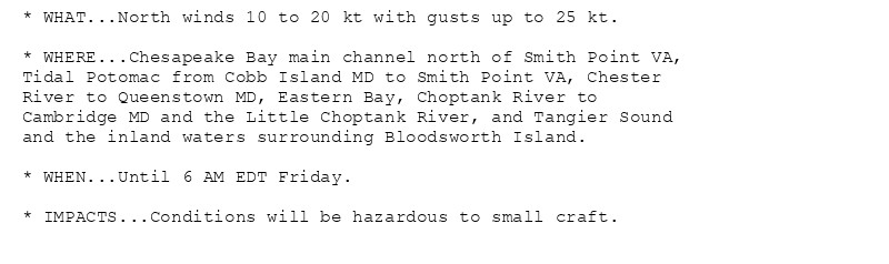
NEW WEATHER ADVISORY: Small Craft Advisory * WHAT...North winds 10 to 20 kt with gusts up to 25 kt. * WHERE...Chesapeake Bay main channel north of Smith Point VA, Tidal Potomac from Cobb Island MD to Smith Point VA, Chester River to Queenstown MD,... See more: watchedsky.social/app/alerts/...

0
Mimpatientbirder.bsky.social

NZ16: New Zealand Pipit, on the alpine road to Queenstown

0

To be fair I’m in New Zealand where we have different signifiers. Eg ‘businessman from Queenstown’ means cocaine.

1
AFwas.nws-bot.us

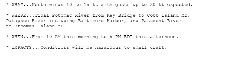
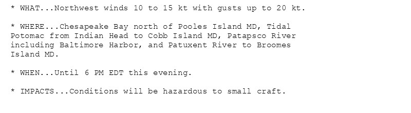
Small Craft Advisory issued October 16 at 6:00PM EDT until October 17 at 5:00PM EDT by NWS Baltimore MD/Washington DC Additional Details Here.

* WHAT...North winds around 10 kt with gusts up to 20 kt
expected.

* WHERE...Tidal Potomac River from Key Bridge to Cobb Island MD,
Patapsco River including Baltimore Harbor, and Patuxent River
to Broomes Island MD.

* WHEN...From 10 AM to 5 PM EDT Thursday.

* IMPACTS...Conditions will be hazardous to small craft.
* WHAT...North winds 10 to 15 kt with gusts up to 25 kt.

* WHERE...Chesapeake Bay main channel north of Smith Point VA,
Tidal Potomac from Cobb Island MD to Smith Point VA, Chester
River to Queenstown MD, Eastern Bay, Choptank River to
Cambridge MD and the Little Choptank River, and Tangier Sound
and the inland waters surrounding Bloodsworth Island.

* WHEN...Until 6 AM EDT Friday.

* IMPACTS...Conditions will be hazardous to small craft.
0
NWskeetbot.watchedsky.social

NEW WEATHER ADVISORY: Small Craft Advisory * WHAT...North winds 10 to 15 kt with gusts up to 25 kt. * WHERE...Chesapeake Bay main channel north of Smith Point VA, Tidal Potomac from Cobb Island MD to Smith Point VA, Chester River to Queenstown MD,... See more: watchedsky.social/app/alerts/...

1
OHolimnz.bsky.social

After reading all the negativity in the first half of the article, you get to this:

On the upside – this is local democracy! In this electoral term, Gore, Kaipara and Invercargill have been more riven; Auckland, Hamilton, Tauranga and Queenstown Lakes are more indebted; West Coast, Hastings, Napier, Gore, Clutha, Buller and Central Hawkes Bay all had to suck up higher rates rises.

Brown is not taking advice on intervening in any of these councils, to our knowledge, though Gore came close to seeking Government help last year.
0
AFwas.nws-bot.us

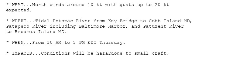
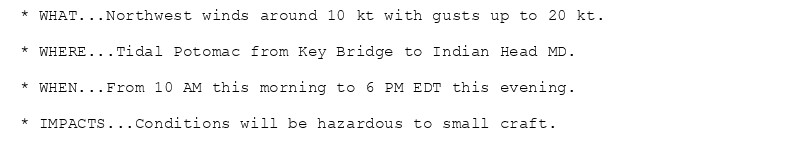
Small Craft Advisory issued October 16 at 6:44AM EDT until October 16 at 6:00PM EDT by NWS Baltimore MD/Washington DC Additional Details Here.

* WHAT...Northwest winds around 10 kt with gusts up to 20 kt.

* WHERE...Tidal Potomac from Key Bridge to Indian Head MD.

* WHEN...From 10 AM this morning to 6 PM EDT this evening.

* IMPACTS...Conditions will be hazardous to small craft.
* WHAT...Northwest winds 10 to 15 kt with gusts up to 20 kt.

* WHERE...Chesapeake Bay north of Pooles Island MD, Tidal
Potomac from Indian Head to Cobb Island MD, Patapsco River
including Baltimore Harbor, and Patuxent River to Broomes
Island MD.

* WHEN...Until 6 PM EDT this evening.

* IMPACTS...Conditions will be hazardous to small craft.
* WHAT...North winds 10 to 15 kt with gusts up to 25 kt.

* WHERE...Chesapeake Bay from Pooles Island MD to Smith Point
VA, Tidal Potomac from Cobb Island MD to Smith Point VA,
Chester River to Queenstown MD, Eastern Bay, Choptank River to
Cambridge MD and the Little Choptank River, and Tangier Sound
and the inland waters surrounding Bloodsworth Island.

* WHEN...Until 6 AM EDT Thursday.

* IMPACTS...Conditions will be hazardous to small craft.
0
NWskeetbot.watchedsky.social

NEW WEATHER ADVISORY: Small Craft Advisory * WHAT...North winds 10 to 15 kt with gusts up to 25 kt. * WHERE...Chesapeake Bay from Pooles Island MD to Smith Point VA, Tidal Potomac from Cobb Island MD to Smith Point VA, Chester River to Queenstown MD,... See more: watchedsky.social/app/alerts/...

0
AFwas.nws-bot.us

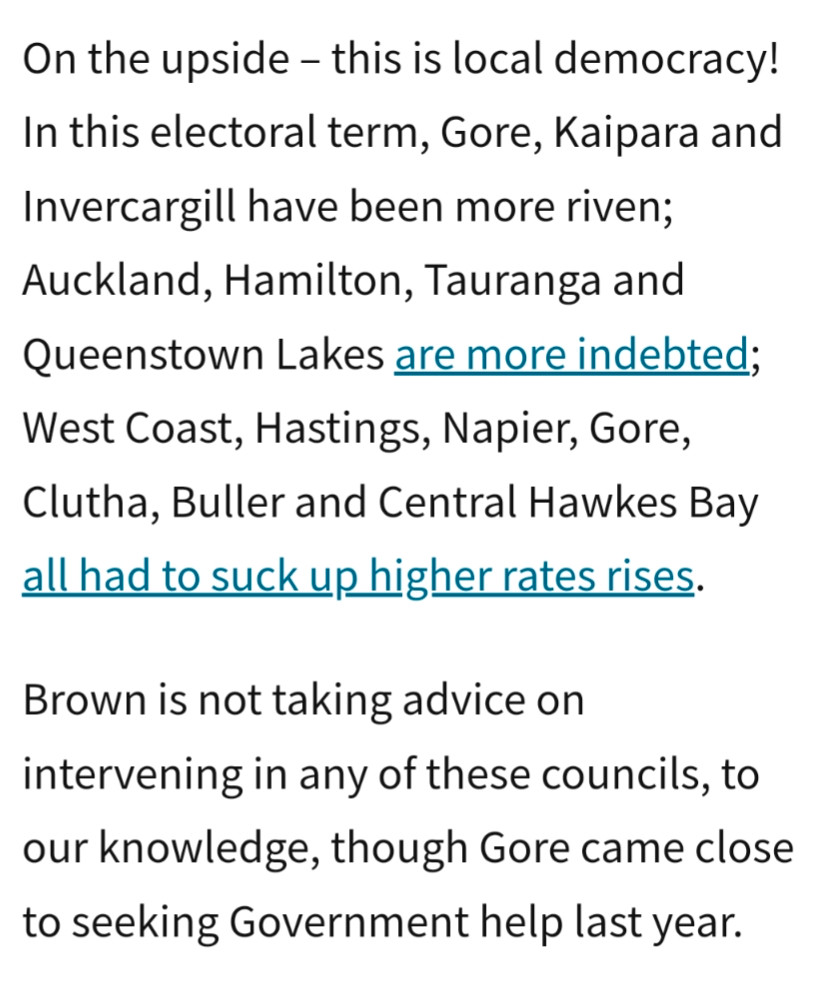
Small Craft Advisory issued October 16 at 1:11AM EDT until October 16 at 6:00PM EDT by NWS Baltimore MD/Washington DC Additional Details Here.

* WHAT...Northwest winds 10 to 15 kt with gusts up to 20 kt.

* WHERE...Chesapeake Bay north of Pooles Island MD, Tidal
Potomac from Indian Head to Cobb Island MD, Patapsco River
including Baltimore Harbor, and Patuxent River to Broomes
Island MD.

* WHEN...Until 6 PM EDT this evening.

* IMPACTS...Conditions will be hazardous to small craft.
* WHAT...Northwest winds around 10 kt with gusts up to 20 kt.

* WHERE...Tidal Potomac from Key Bridge to Indian Head MD.

* WHEN...From 10 AM this morning to 6 PM EDT this evening.

* IMPACTS...Conditions will be hazardous to small craft.
* WHAT...North winds 10 to 15 kt with gusts up to 25 kt.

* WHERE...Chesapeake Bay from Pooles Island MD to Smith Point
VA, Tidal Potomac from Cobb Island MD to Smith Point VA,
Chester River to Queenstown MD, Eastern Bay, Choptank River to
Cambridge MD and the Little Choptank River, and Tangier Sound
and the inland waters surrounding Bloodsworth Island.

* WHEN...Until 6 AM EDT Thursday.

* IMPACTS...Conditions will be hazardous to small craft.
0