BLUE
STspc-storms.nws-bot.us

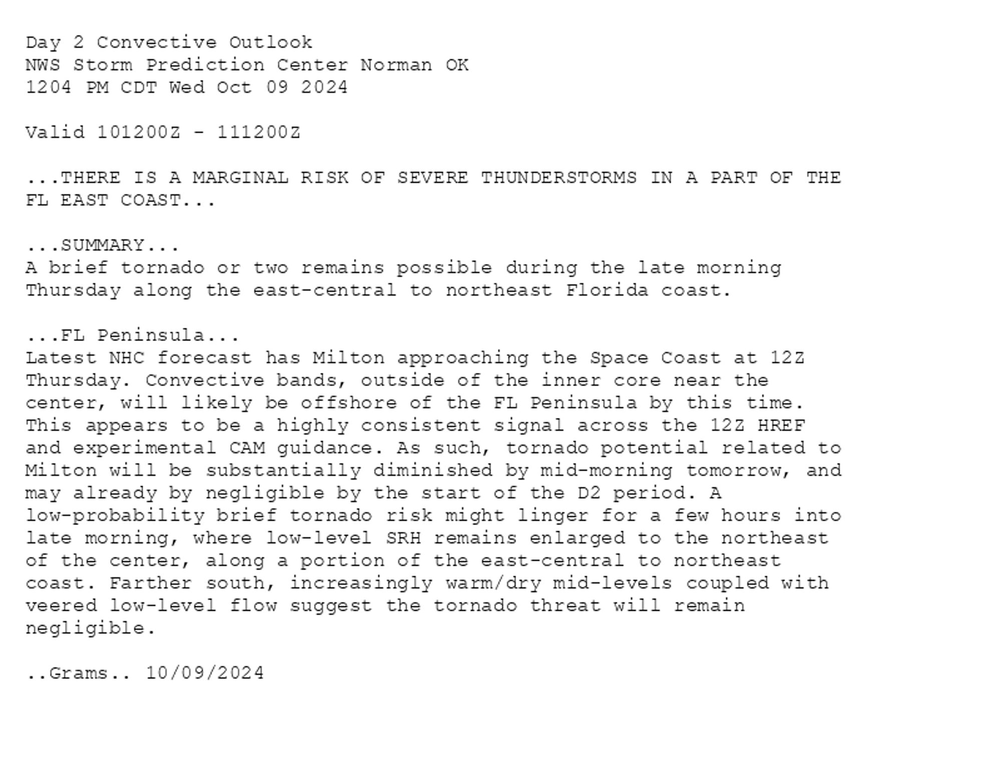
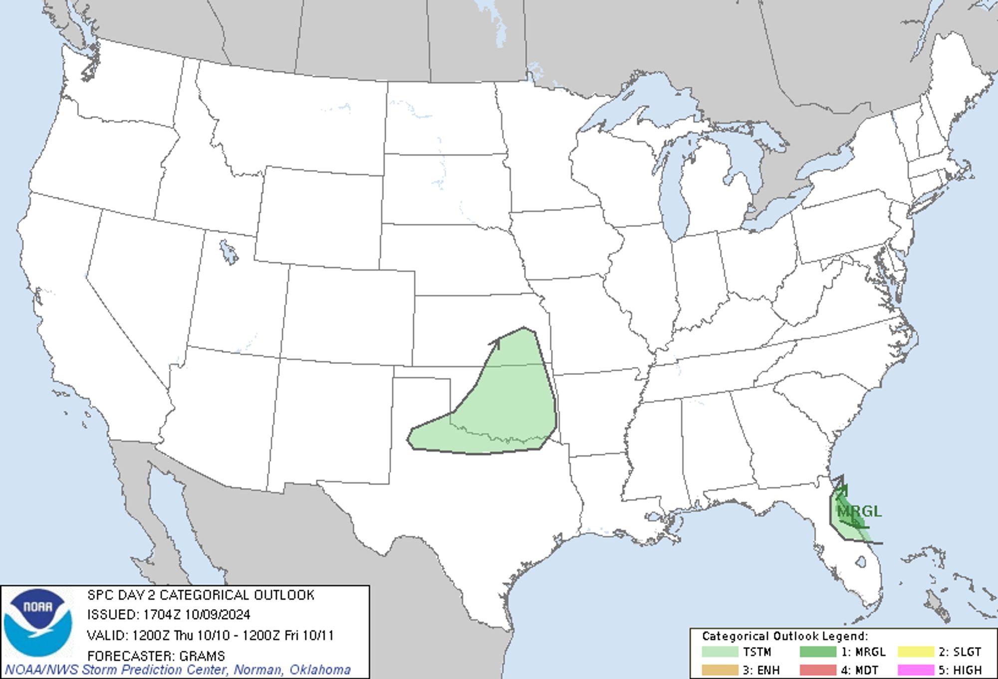
SPC Oct 9, 2024 1730 UTC Day 2 Convective Outlook ⛈️THERE IS A MARGINAL RISK OF SEVERE THUNDERSTORMS IN A PART OF THE FL EAST COAST🌪️ Additional Details Here.


Day 2 Convective Outlook  
NWS Storm Prediction Center Norman OK
1204 PM CDT Wed Oct 09 2024

Valid 101200Z - 111200Z

...THERE IS A MARGINAL RISK OF SEVERE THUNDERSTORMS IN A PART OF THE
FL EAST COAST...

...SUMMARY...
A brief tornado or two remains possible during the late morning
Thursday along the east-central to northeast Florida coast.

...FL Peninsula...
Latest NHC forecast has Milton approaching the Space Coast at 12Z
Thursday. Convective bands, outside of the inner core near the
center, will likely be offshore of the FL Peninsula by this time.
This appears to be a highly consistent signal across the 12Z HREF
and experimental CAM guidance. As such, tornado potential related to
Milton will be substantially diminished by mid-morning tomorrow, and
may already by negligible by the start of the D2 period. A
low-probability brief tornado risk might linger for a few hours into
late morning, where low-level SRH remains enlarged to the northeast
of the center, along a portion of the east-central to northeast
coast. Farther south, increasingly warm/dry mid-levels coupled with
veered low-level flow suggest the tornado threat will remain
negligible.

..Grams.. 10/09/2024
Day 2 Outlook Image
0
STspc-storms.nws-bot.us

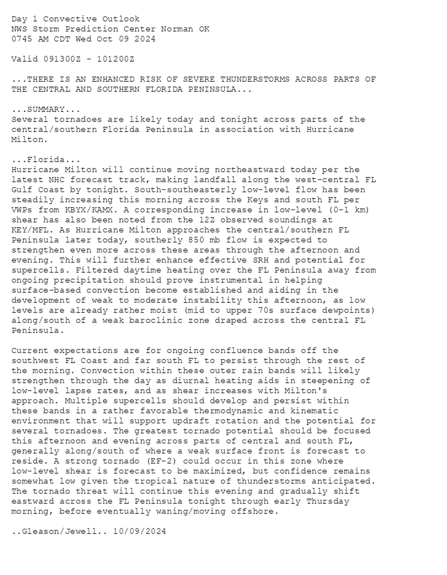
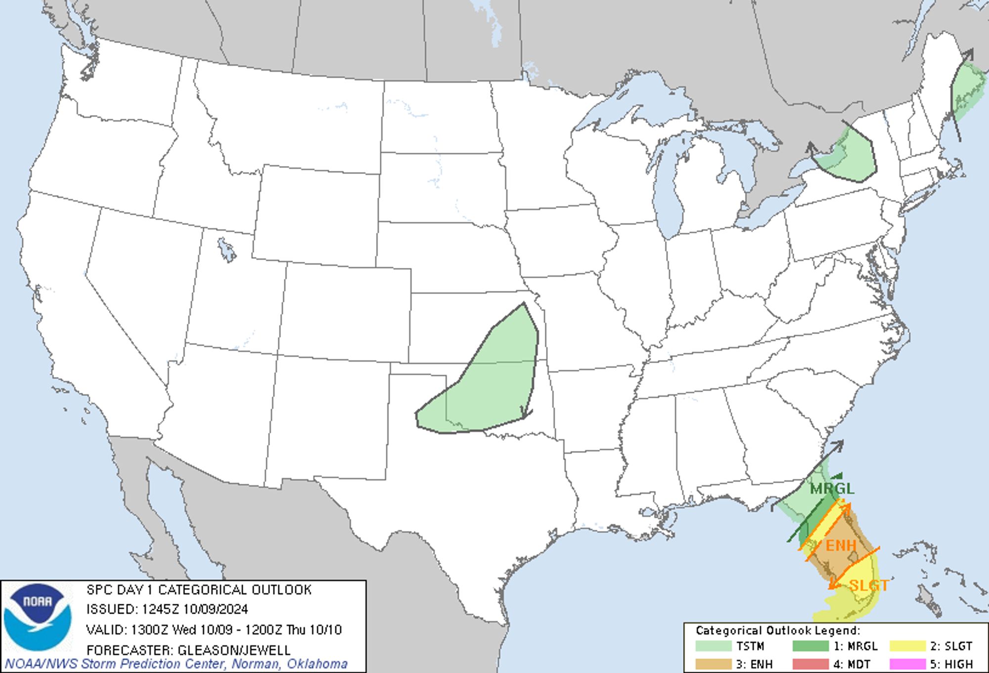
SPC Oct 9, 2024 1300 UTC Day 1 Convective Outlook ⛈️THERE IS AN ENHANCED RISK OF SEVERE THUNDERSTORMS ACROSS PARTS OF THE CENTRAL AND SOUTHERN FLORIDA PENINSULA🌪️ Additional Details Here.


Day 1 Convective Outlook  
NWS Storm Prediction Center Norman OK
0745 AM CDT Wed Oct 09 2024

Valid 091300Z - 101200Z

...THERE IS AN ENHANCED RISK OF SEVERE THUNDERSTORMS ACROSS PARTS OF
THE CENTRAL AND SOUTHERN FLORIDA PENINSULA...

...SUMMARY...
Several tornadoes are likely today and tonight across parts of the
central/southern Florida Peninsula in association with Hurricane
Milton.

...Florida...
Hurricane Milton will continue moving northeastward today per the
latest NHC forecast track, making landfall along the west-central FL
Gulf Coast by tonight. South-southeasterly low-level flow has been
steadily increasing this morning across the Keys and south FL per
VWPs from KBYX/KAMX. A corresponding increase in low-level (0-1 km)
shear has also been noted from the 12Z observed soundings at
KEY/MFL. As Hurricane Milton approaches the central/southern FL
Peninsula later today, southerly 850 mb flow is expected to
strengthen even more across these areas through the afternoon and
evening. This will further enhance effective SRH and potential for
supercells. Filtered daytime heating over the FL Peninsula away from
ongoing precipitation should prove instrumental in helping
surface-based convection become established and aiding in the
development of weak to moderate instability this afternoon, as low
levels are already rather moist (mid to upper 70s surface dewpoints)
along/south of a weak baroclinic zone draped across the central FL
Peninsula.

Current expectations are for ongoing confluence bands off the
southwest FL Coast and far south FL to persist through the rest of
the morning. Convection within these outer rain bands will likely
strengthen through the day as diurnal heating aids in steepening of
low-level lapse rates, and as shear increases with Milton's
approach. Multiple supercells should develop and persist within
these bands in a rather favorable thermodynamic and kinematic
environment that will support updraft rotation and the potential for
several tornadoes. The greatest tornado potential should be focused
this afternoon and evening across parts of central and south FL,
generally along/south of where a weak surface front is forecast to
reside. A strong tornado (EF-2) could occur in this zone where
low-level shear is forecast to be maximized, but confidence remains
somewhat low given the tropical nature of thunderstorms anticipated.
The tornado threat will continue this evening and gradually shift
eastward across the FL Peninsula tonight through early Thursday
morning, before eventually waning/moving offshore.

..Gleason/Jewell.. 10/09/2024
Day 1 Outlook Image
0
BMbmcnoldy.bsky.social

In short: 1) There's more to the story than the category. 2) The track cone is not an impacts cone. The HTI products have been an excellent impact communication tool since they became an operational in 2015: www.weather.gov/srh/tropical...

2
STspc-storms.nws-bot.us

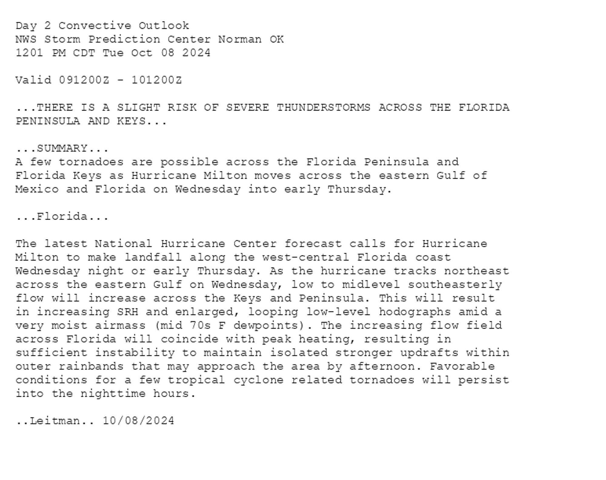
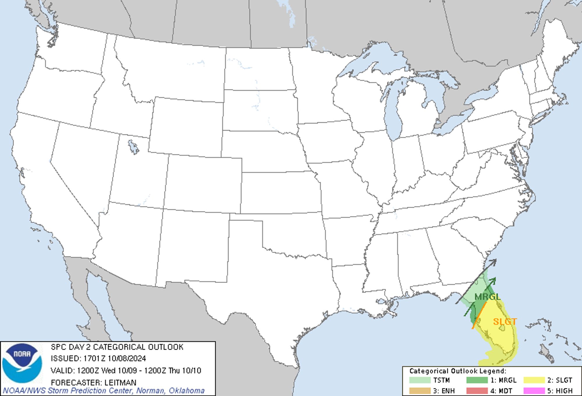
SPC Oct 8, 2024 1730 UTC Day 2 Convective Outlook ⛈️THERE IS A SLIGHT RISK OF SEVERE THUNDERSTORMS ACROSS THE FLORIDA PENINSULA AND KEYS🌪️ Additional Details Here.


Day 2 Convective Outlook  
NWS Storm Prediction Center Norman OK
1201 PM CDT Tue Oct 08 2024

Valid 091200Z - 101200Z

...THERE IS A SLIGHT RISK OF SEVERE THUNDERSTORMS ACROSS THE FLORIDA
PENINSULA AND KEYS...

...SUMMARY...
A few tornadoes are possible across the Florida Peninsula and
Florida Keys as Hurricane Milton moves across the eastern Gulf of
Mexico and Florida on Wednesday into early Thursday.

...Florida...

The latest National Hurricane Center forecast calls for Hurricane
Milton to make landfall along the west-central Florida coast
Wednesday night or early Thursday. As the hurricane tracks northeast
across the eastern Gulf on Wednesday, low to midlevel southeasterly
flow will increase across the Keys and Peninsula. This will result
in increasing SRH and enlarged, looping low-level hodographs amid a
very moist airmass (mid 70s F dewpoints). The increasing flow field
across Florida will coincide with peak heating, resulting in
sufficient instability to maintain isolated stronger updrafts within
outer rainbands that may approach the area by afternoon. Favorable
conditions for a few tropical cyclone related tornadoes will persist
into the nighttime hours.

..Leitman.. 10/08/2024
Day 2 Outlook Image
0
STspc-storms.nws-bot.us

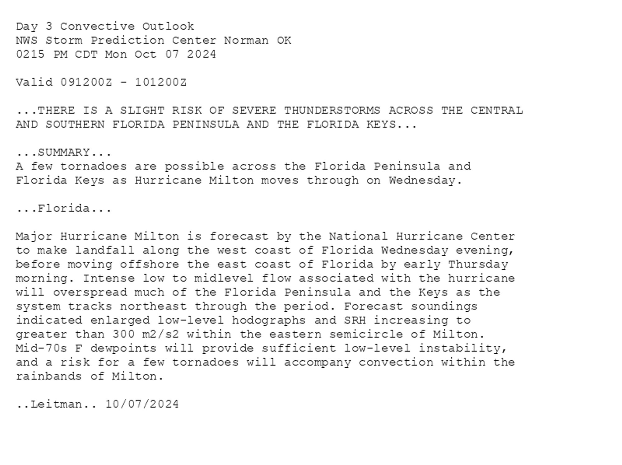
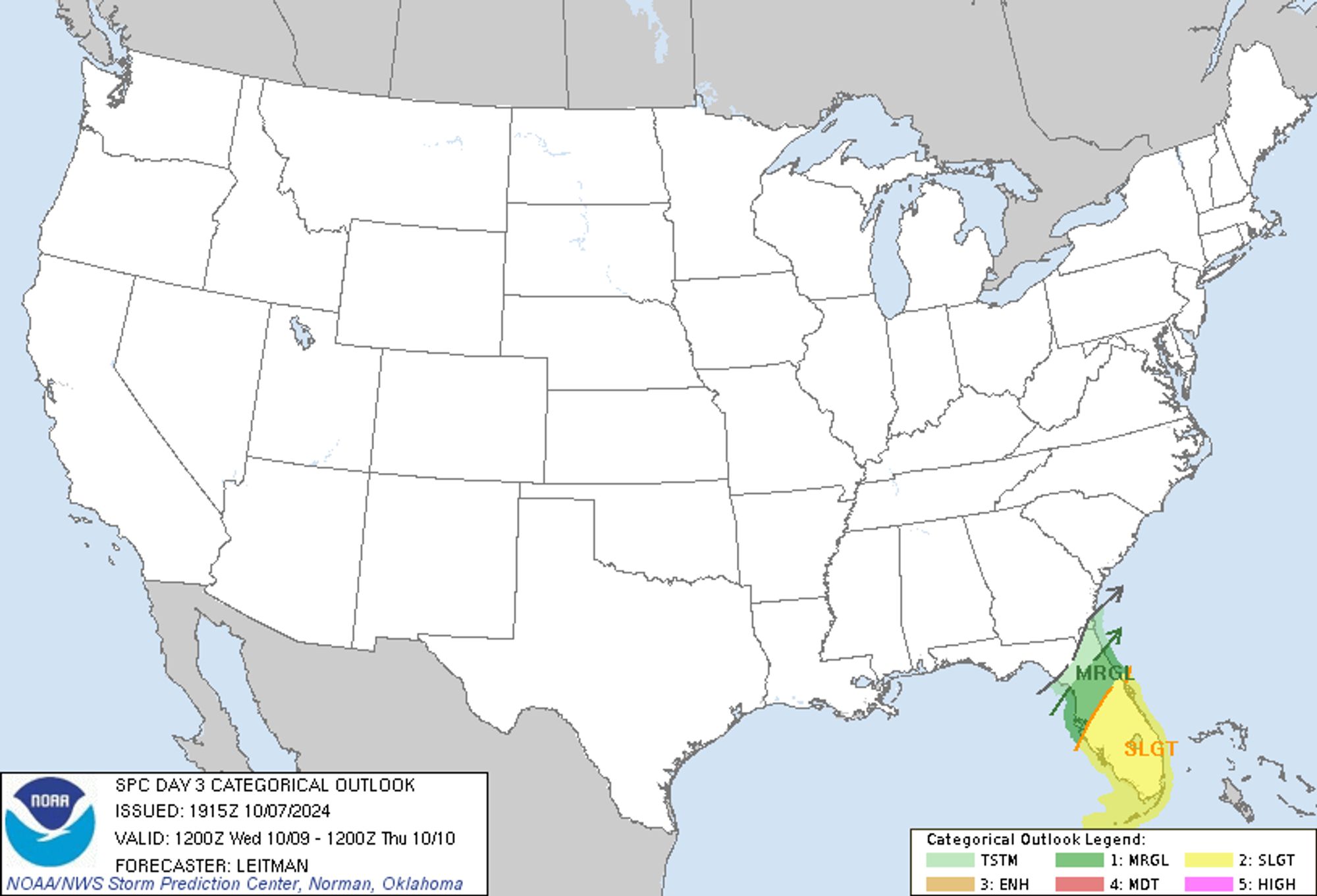
SPC Oct 7, 2024 1930 UTC Day 3 Severe Thunderstorm Outlook ⛈️THERE IS A SLIGHT RISK OF SEVERE THUNDERSTORMS ACROSS THE CENTRAL AND SOUTHERN FLORIDA PENINSULA AND THE FLORIDA KEYS🌪️ Additional Details Here.


Day 3 Convective Outlook  
NWS Storm Prediction Center Norman OK
0215 PM CDT Mon Oct 07 2024

Valid 091200Z - 101200Z

...THERE IS A SLIGHT RISK OF SEVERE THUNDERSTORMS ACROSS THE CENTRAL
AND SOUTHERN FLORIDA PENINSULA AND THE FLORIDA KEYS...

...SUMMARY...
A few tornadoes are possible across the Florida Peninsula and
Florida Keys as Hurricane Milton moves through on Wednesday.

...Florida...

Major Hurricane Milton is forecast by the National Hurricane Center
to make landfall along the west coast of Florida Wednesday evening,
before moving offshore the east coast of Florida by early Thursday
morning. Intense low to midlevel flow associated with the hurricane
will overspread much of the Florida Peninsula and the Keys as the
system tracks northeast through the period. Forecast soundings
indicated enlarged low-level hodographs and SRH increasing to
greater than 300 m2/s2 within the eastern semicircle of Milton.
Mid-70s F dewpoints will provide sufficient low-level instability,
and a risk for a few tornadoes will accompany convection within the
rainbands of Milton.

..Leitman.. 10/07/2024
Day 3 Outlook Image
0
STspc-storms.nws-bot.us

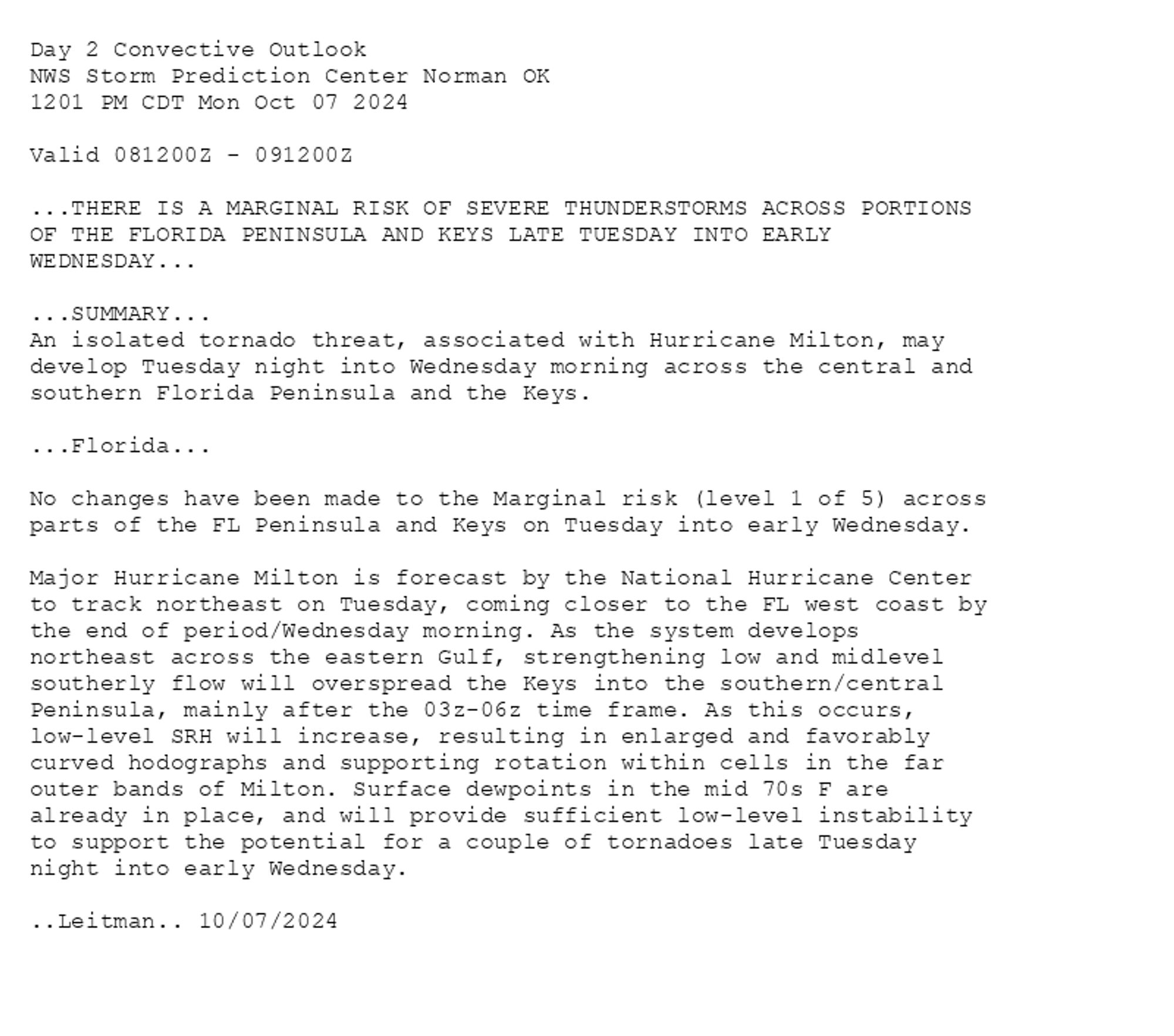
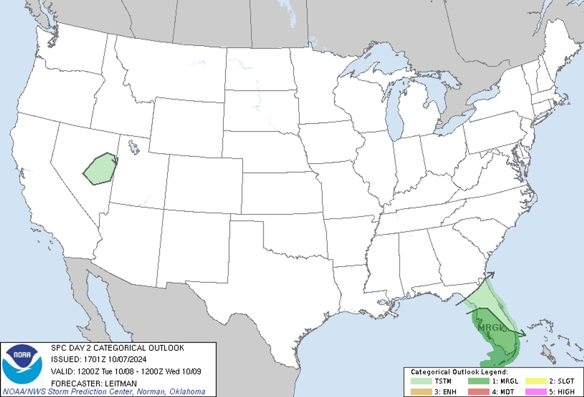
SPC Oct 7, 2024 1730 UTC Day 2 Convective Outlook ⛈️THERE IS A MARGINAL RISK OF SEVERE THUNDERSTORMS ACROSS PORTIONS OF THE FLORIDA PENINSULA AND KEYS LATE TUESDAY INTO EARLY WEDNESDAY🌪️ Additional Details Here.


Day 2 Convective Outlook  
NWS Storm Prediction Center Norman OK
1201 PM CDT Mon Oct 07 2024

Valid 081200Z - 091200Z

...THERE IS A MARGINAL RISK OF SEVERE THUNDERSTORMS ACROSS PORTIONS
OF THE FLORIDA PENINSULA AND KEYS LATE TUESDAY INTO EARLY
WEDNESDAY...

...SUMMARY...
An isolated tornado threat, associated with Hurricane Milton, may
develop Tuesday night into Wednesday morning across the central and
southern Florida Peninsula and the Keys.

...Florida...

No changes have been made to the Marginal risk (level 1 of 5) across
parts of the FL Peninsula and Keys on Tuesday into early Wednesday. 

Major Hurricane Milton is forecast by the National Hurricane Center
to track northeast on Tuesday, coming closer to the FL west coast by
the end of period/Wednesday morning. As the system develops
northeast across the eastern Gulf, strengthening low and midlevel
southerly flow will overspread the Keys into the southern/central
Peninsula, mainly after the 03z-06z time frame. As this occurs,
low-level SRH will increase, resulting in enlarged and favorably
curved hodographs and supporting rotation within cells in the far
outer bands of Milton. Surface dewpoints in the mid 70s F are
already in place, and will provide sufficient low-level instability
to support the potential for a couple of tornadoes late Tuesday
night into early Wednesday.

..Leitman.. 10/07/2024
Day 2 Outlook Image
0
STspc-storms.nws-bot.us

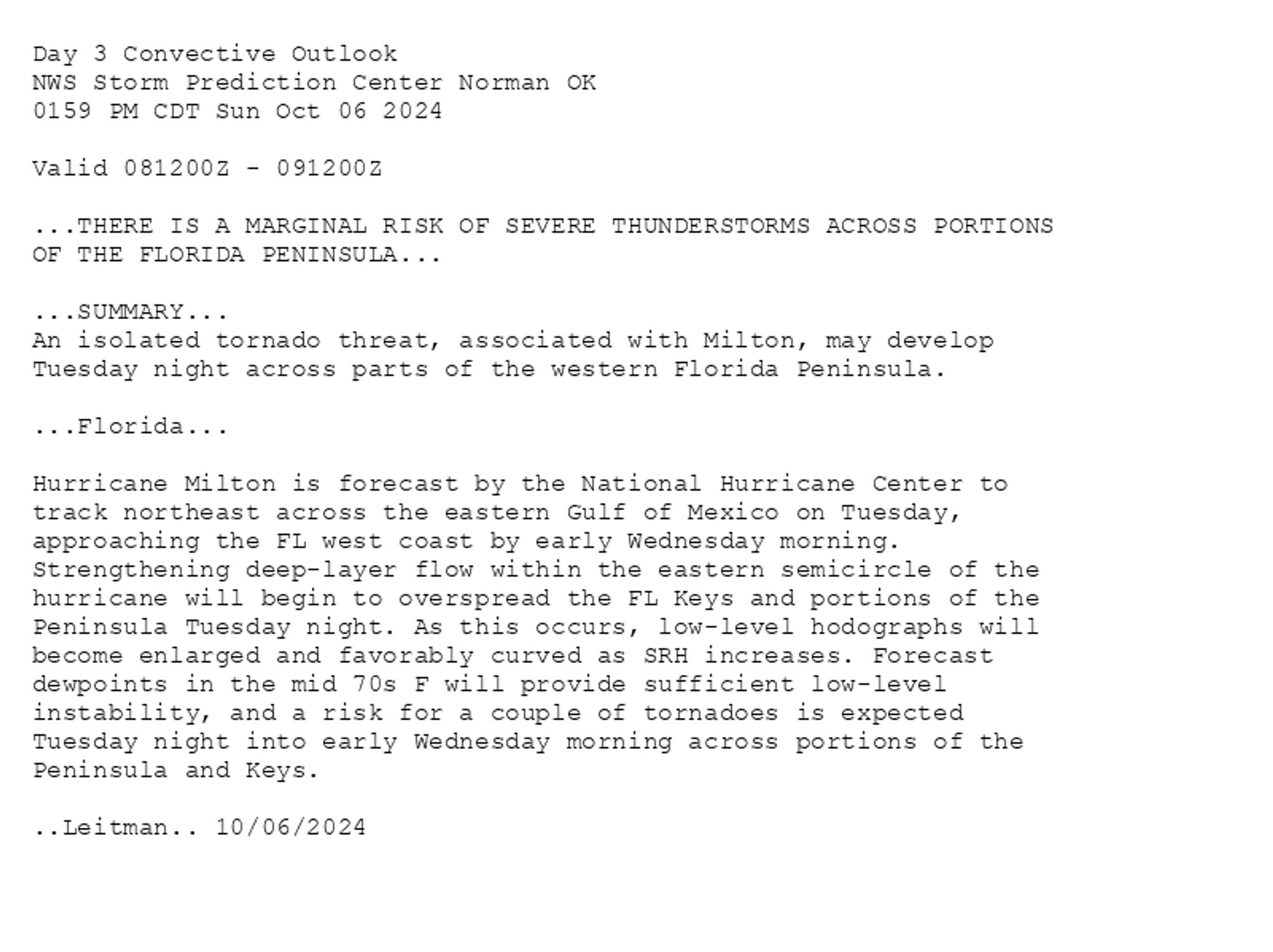
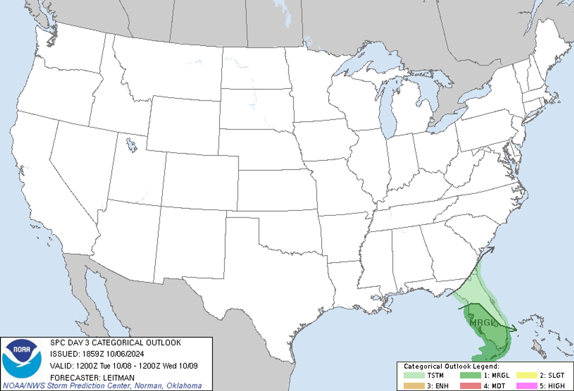
SPC Oct 6, 2024 1930 UTC Day 3 Severe Thunderstorm Outlook ⛈️THERE IS A MARGINAL RISK OF SEVERE THUNDERSTORMS ACROSS PORTIONS OF THE FLORIDA PENINSULA🌪️ Additional Details Here.


Day 3 Convective Outlook  
NWS Storm Prediction Center Norman OK
0159 PM CDT Sun Oct 06 2024

Valid 081200Z - 091200Z

...THERE IS A MARGINAL RISK OF SEVERE THUNDERSTORMS ACROSS PORTIONS
OF THE FLORIDA PENINSULA...

...SUMMARY...
An isolated tornado threat, associated with Milton, may develop
Tuesday night across parts of the western Florida Peninsula.

...Florida...

Hurricane Milton is forecast by the National Hurricane Center to
track northeast across the eastern Gulf of Mexico on Tuesday,
approaching the FL west coast by early Wednesday morning.
Strengthening deep-layer flow within the eastern semicircle of the
hurricane will begin to overspread the FL Keys and portions of the
Peninsula Tuesday night. As this occurs, low-level hodographs will
become enlarged and favorably curved as SRH increases. Forecast
dewpoints in the mid 70s F will provide sufficient low-level
instability, and a risk for a couple of tornadoes is expected
Tuesday night into early Wednesday morning across portions of the
Peninsula and Keys.

..Leitman.. 10/06/2024
Day 3 Outlook Image
0
viviinfo.bsky.social

るうず『永遠論』『せかいめつぼー』各ショップにてオンライン取扱中です。(looose☆sekaiseihukuレーベル) #るうずリリース情報#るうず2枚同時リリースtower.jp/artist/5756157diskunion.net/portal/ct/li...www.hmv.co.jp/artist_%E3%8...bridge-inc.net?mode=srh&cid...

0
STspc-storms.nws-bot.us

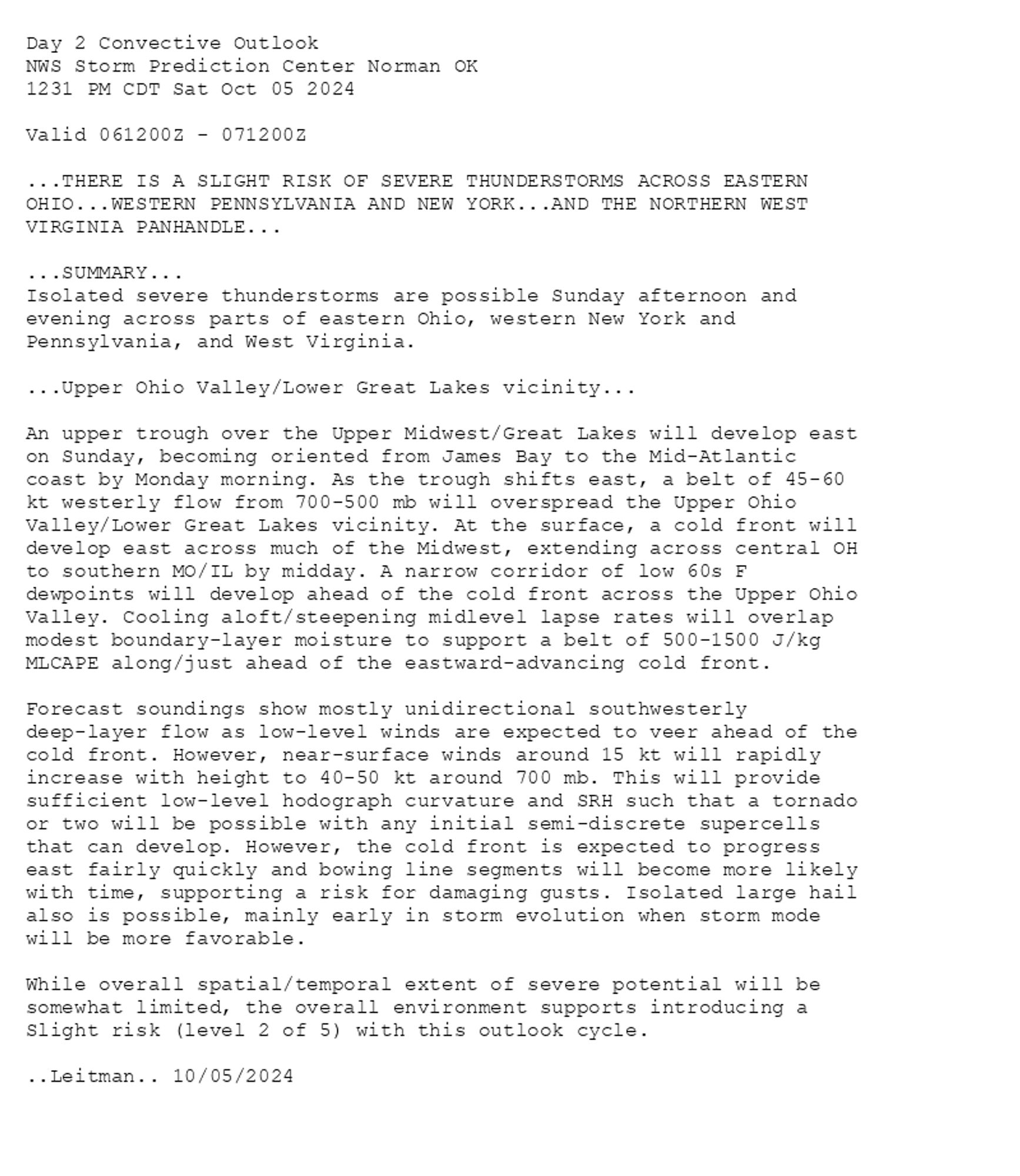
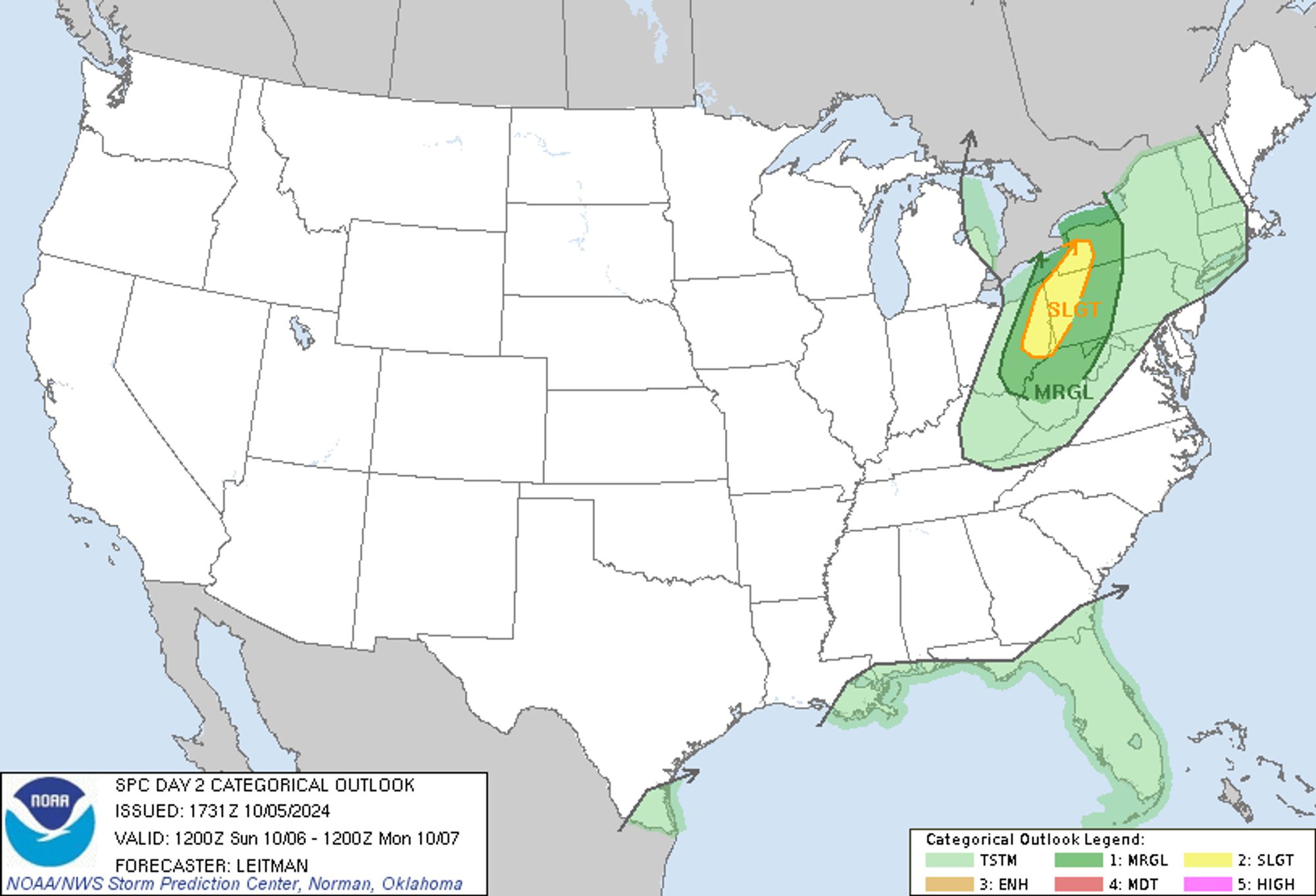
SPC Oct 5, 2024 1730 UTC Day 2 Convective Outlook ⛈️THERE IS A SLIGHT RISK OF SEVERE THUNDERSTORMS ACROSS EASTERN OHIO🌪️ Additional Details Here.


Day 2 Convective Outlook  
NWS Storm Prediction Center Norman OK
1231 PM CDT Sat Oct 05 2024

Valid 061200Z - 071200Z

...THERE IS A SLIGHT RISK OF SEVERE THUNDERSTORMS ACROSS EASTERN
OHIO...WESTERN PENNSYLVANIA AND NEW YORK...AND THE NORTHERN WEST
VIRGINIA PANHANDLE...

...SUMMARY...
Isolated severe thunderstorms are possible Sunday afternoon and
evening across parts of eastern Ohio, western New York and
Pennsylvania, and West Virginia.

...Upper Ohio Valley/Lower Great Lakes vicinity...

An upper trough over the Upper Midwest/Great Lakes will develop east
on Sunday, becoming oriented from James Bay to the Mid-Atlantic
coast by Monday morning. As the trough shifts east, a belt of 45-60
kt westerly flow from 700-500 mb will overspread the Upper Ohio
Valley/Lower Great Lakes vicinity. At the surface, a cold front will
develop east across much of the Midwest, extending across central OH
to southern MO/IL by midday. A narrow corridor of low 60s F
dewpoints will develop ahead of the cold front across the Upper Ohio
Valley. Cooling aloft/steepening midlevel lapse rates will overlap
modest boundary-layer moisture to support a belt of 500-1500 J/kg
MLCAPE along/just ahead of the eastward-advancing cold front. 

Forecast soundings show mostly unidirectional southwesterly
deep-layer flow as low-level winds are expected to veer ahead of the
cold front. However, near-surface winds around 15 kt will rapidly
increase with height to 40-50 kt around 700 mb. This will provide
sufficient low-level hodograph curvature and SRH such that a tornado
or two will be possible with any initial semi-discrete supercells
that can develop. However, the cold front is expected to progress
east fairly quickly and bowing line segments will become more likely
with time, supporting a risk for damaging gusts. Isolated large hail
also is possible, mainly early in storm evolution when storm mode
will be more favorable. 

While overall spatial/temporal extent of severe potential will be
somewhat limited, the overall environment supports introducing a
Slight risk (level 2 of 5) with this outlook cycle.

..Leitman.. 10/05/2024
Day 2 Outlook Image
0
JBmissjbastos.bsky.social

" ... Ready-ah? The fire & action you all loved is making a massy massy massy arrival in Japan! #Jawan hits the screens in Japan on 29th Nov, 2024! " Via SRH ❤🕊

0