BLUE
AFmfr.nws-bot.us

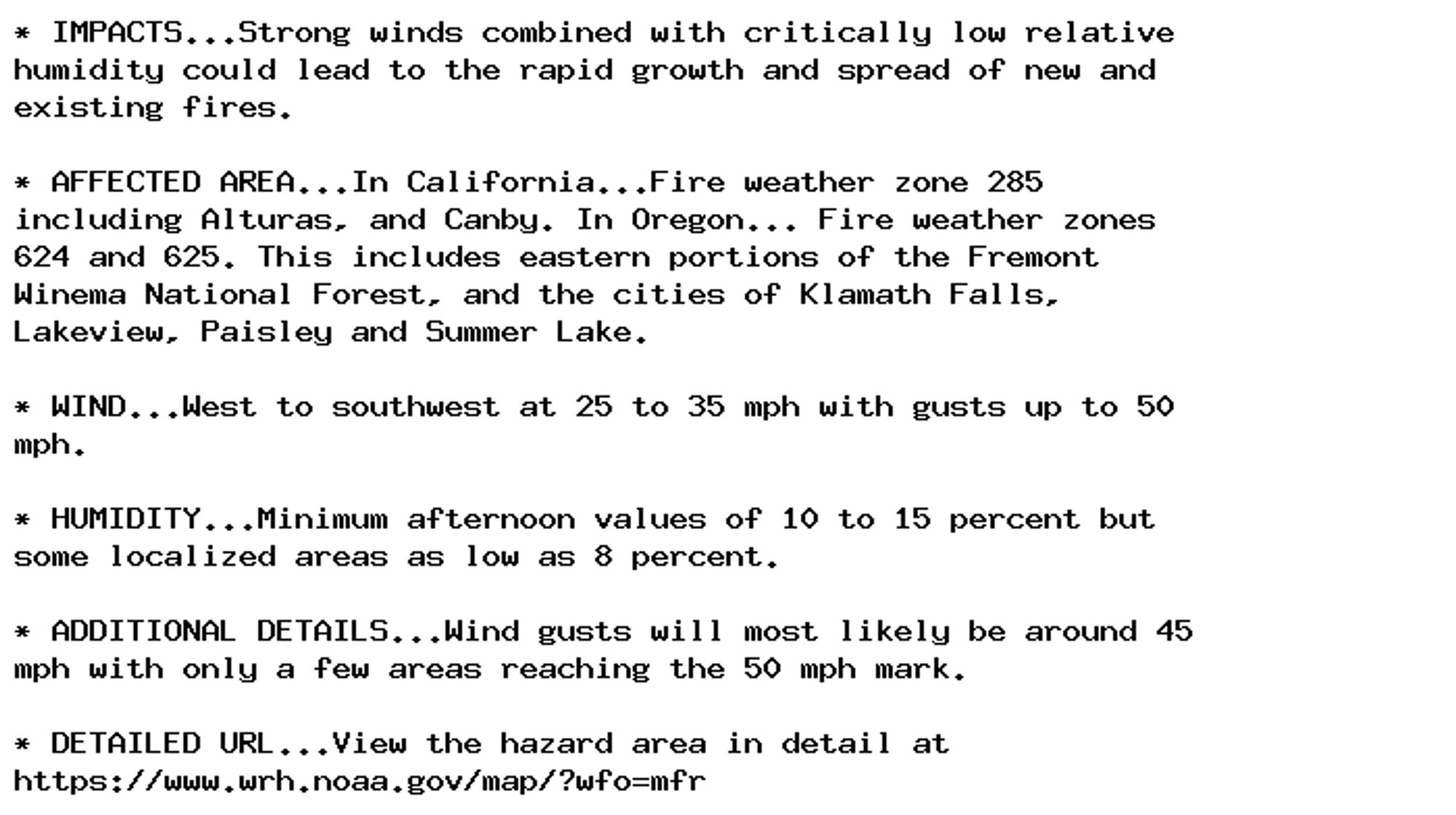
🚨 Red Flag Warning issued October 4 at 1:51PM PDT until October 4 at 8:00PM PDT by NWS Medford OR 🚨 Additional Details Here.

* IMPACTS...Strong winds combined with critically low relative
humidity could lead to the rapid growth and spread of new and
existing fires.

* AFFECTED AREA...In California...Fire weather zone 285
including Alturas, and Canby. In Oregon... Fire weather zones
624 and 625. This includes eastern portions of the Fremont
Winema National Forest, and the cities of Klamath Falls,
Lakeview, Paisley and Summer Lake.

* WIND...West to southwest at 25 to 35 mph with gusts up to 50
mph.

* HUMIDITY...Minimum afternoon values of 10 to 15 percent but
some localized areas as low as 8 percent.

* ADDITIONAL DETAILS...Wind gusts will most likely be around 45
mph with only a few areas reaching the 50 mph mark.

* DETAILED URL...View the hazard area in detail at
https://www.wrh.noaa.gov/map/?wfo=mfr
0
JVjoeveyera.bsky.social

From Oct. 7 through Nov. 8, free plastic film recycling (bread bags, bubble wrap, etc.) will be offered at five PCC Community Markets locations — Ballard, Central District, Columbia City, Fremont and View Ridge — in partnership with Seadrunar.

Recycle Plastic Film at Five PCC Stores This Fall

Five PCC stores will offer free plastic film recycling from Oct. 7 to Nov. 8 in a pilot project with Seadrunar Recyling.

0
AFriw.nws-bot.us

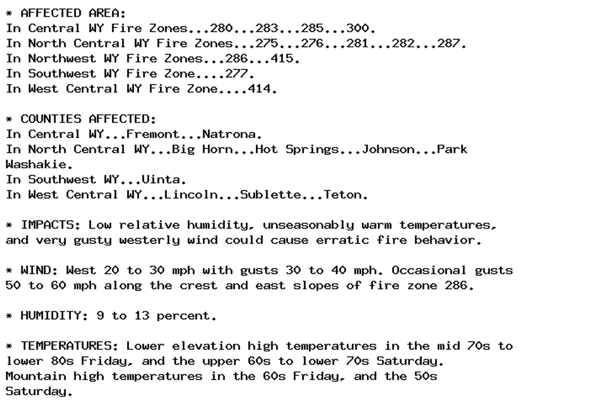
🚨 Red Flag Warning issued October 4 at 1:11PM MDT until October 5 at 9:00PM MDT by NWS Riverton WY 🚨 Additional Details Here.

* AFFECTED AREA:
In Central WY Fire Zones...288...289.
In Southwest WY Fire Zone....279.
In West Central WY Fire Zones...278...416.

* COUNTIES AFFECTED:
In Central WY...Fremont...Natrona.
In Southwest WY...Sweetwater.
In West Central WY...Lincoln...Sublette.

* IMPACTS: Low relative humidity, unseasonably warm temperatures,
and very gusty westerly wind could cause erratic fire behavior.

* WIND: West 20 to 30 mph with gusts 30 to 40 mph. Occasional gusts
50 to 60 mph in fire zones 288 and 289.

* HUMIDITY: As low as 8 percent Friday, 13 to 18 percent Saturday.

* TEMPERATURES: Lower elevation high temperatures in the mid 70s to
lower 80s Friday, and the upper 60s to lower 70s Saturday.
Mountain high temperatures in the 60s Friday, and the 50s
Saturday.
0
AFriw.nws-bot.us

🚨 Red Flag Warning issued October 4 at 1:11PM MDT until October 5 at 7:00PM MDT by NWS Riverton WY 🚨 Additional Details Here.

* AFFECTED AREA:
In Central WY Fire Zones...280...283...285...300.
In North Central WY Fire Zones...275...276...281...282...287.
In Northwest WY Fire Zones...286...415.
In Southwest WY Fire Zone....277.
In West Central WY Fire Zone....414.

* COUNTIES AFFECTED:
In Central WY...Fremont...Natrona.
In North Central WY...Big Horn...Hot Springs...Johnson...Park
Washakie.
In Southwest WY...Uinta.
In West Central WY...Lincoln...Sublette...Teton.

* IMPACTS: Low relative humidity, unseasonably warm temperatures,
and very gusty westerly wind could cause erratic fire behavior.

* WIND: West 20 to 30 mph with gusts 30 to 40 mph. Occasional gusts
50 to 60 mph along the crest and east slopes of fire zone 286.

* HUMIDITY: 9 to 13 percent.

* TEMPERATURES: Lower elevation high temperatures in the mid 70s to
lower 80s Friday, and the upper 60s to lower 70s Saturday.
Mountain high temperatures in the 60s Friday, and the 50s
Saturday.
0
AFoax.nws-bot.us

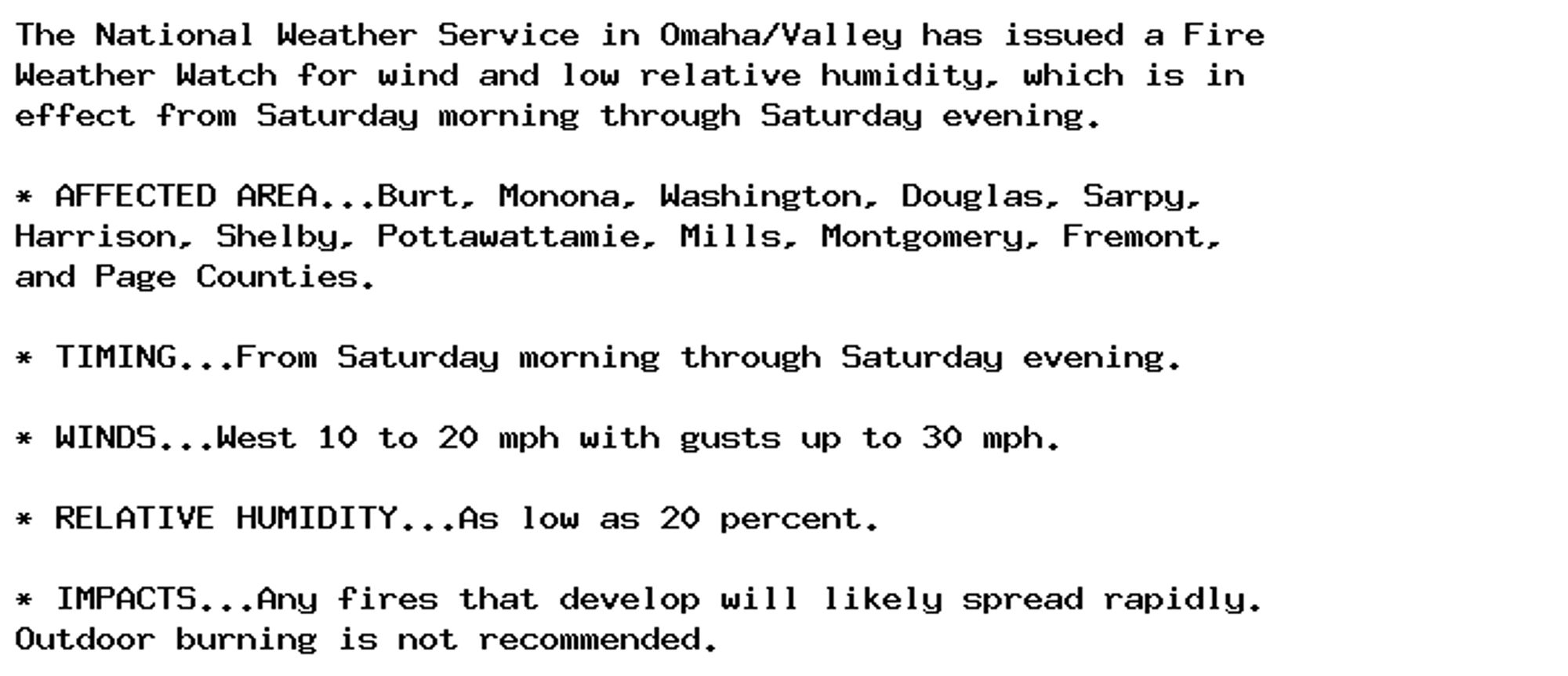
🚨 Fire Weather Watch issued October 4 at 2:13PM CDT until October 5 at 8:00PM CDT by NWS Omaha/Valley NE 🚨 Additional Details Here.

The National Weather Service in Omaha/Valley has issued a Fire
Weather Watch for wind and low relative humidity, which is in
effect from Saturday morning through Saturday evening.

* AFFECTED AREA...Burt, Monona, Washington, Douglas, Sarpy,
Harrison, Shelby, Pottawattamie, Mills, Montgomery, Fremont,
and Page Counties.

* TIMING...From Saturday morning through Saturday evening.

* WINDS...West 10 to 20 mph with gusts up to 30 mph.

* RELATIVE HUMIDITY...As low as 20 percent.

* IMPACTS...Any fires that develop will likely spread rapidly.
Outdoor burning is not recommended.
0

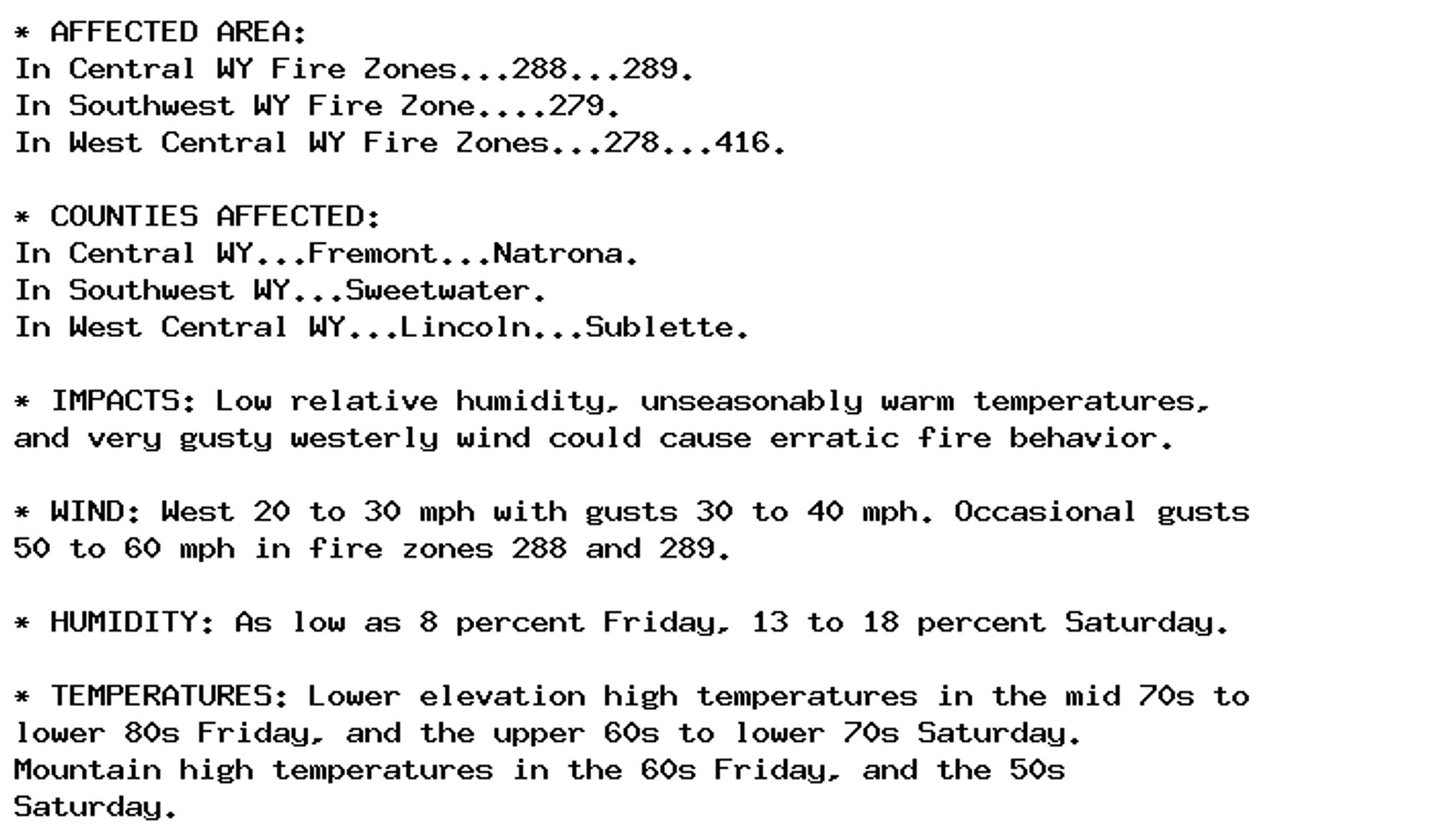
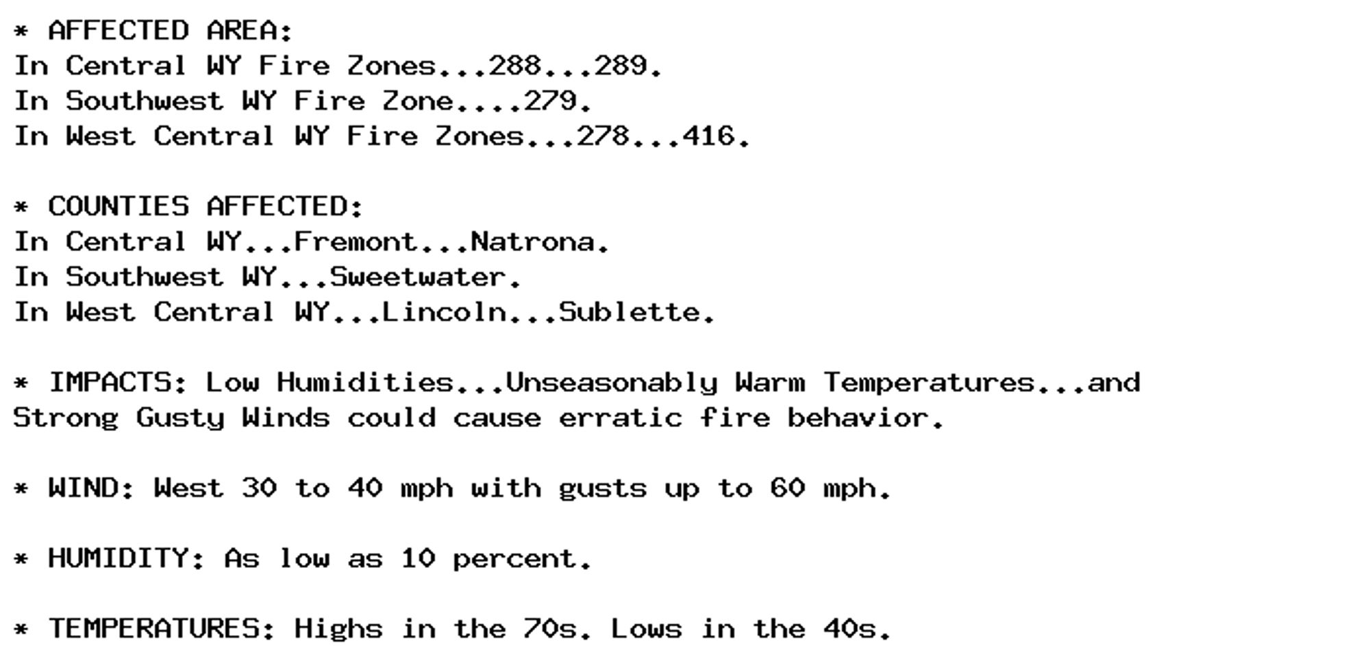
NEW WEATHER ADVISORY: Red Flag Warning * AFFECTED AREA: In Central WY Fire Zones...288...289. In Southwest WY Fire Zone....279. In West Central WY Fire Zones...278...416. * COUNTIES AFFECTED: In Central WY...Fremont...Natrona. In Southwest... See more: watchedsky.social/app/alerts/...

0
AFmfr.nws-bot.us

🚨 Red Flag Warning issued October 4 at 4:27AM PDT until October 4 at 8:00PM PDT by NWS Medford OR 🚨 Additional Details Here.

* IMPACTS...Strong winds combined with critically low relative
humidity could lead to the rapid growth and spread of new and
existing fires.

* AFFECTED AREA...In California...Fire weather zone 285
including Alturas, and Canby. In Oregon... Fire weather zones
624 and 625. This includes eastern portions of the Fremont
Winema National Forest, and the cities of Klamath Falls,
Lakeview, Paisley and Summer Lake.

* WIND...West to southwest at 15 to 30 mph with gusts up to 50
mph.

* HUMIDITY...Minimum afternoon values of 10 to 20 percent but
some localized areas as low as 8 percent.

* ADDITIONAL DETAILS...Wind gusts will most likely be around 45
mph with only a few areas reaching the 50 mph mark.

* DETAILED URL...View the hazard area in detail at
https://www.wrh.noaa.gov/map/?wfo=mfr
0
AFdmx.nws-bot.us

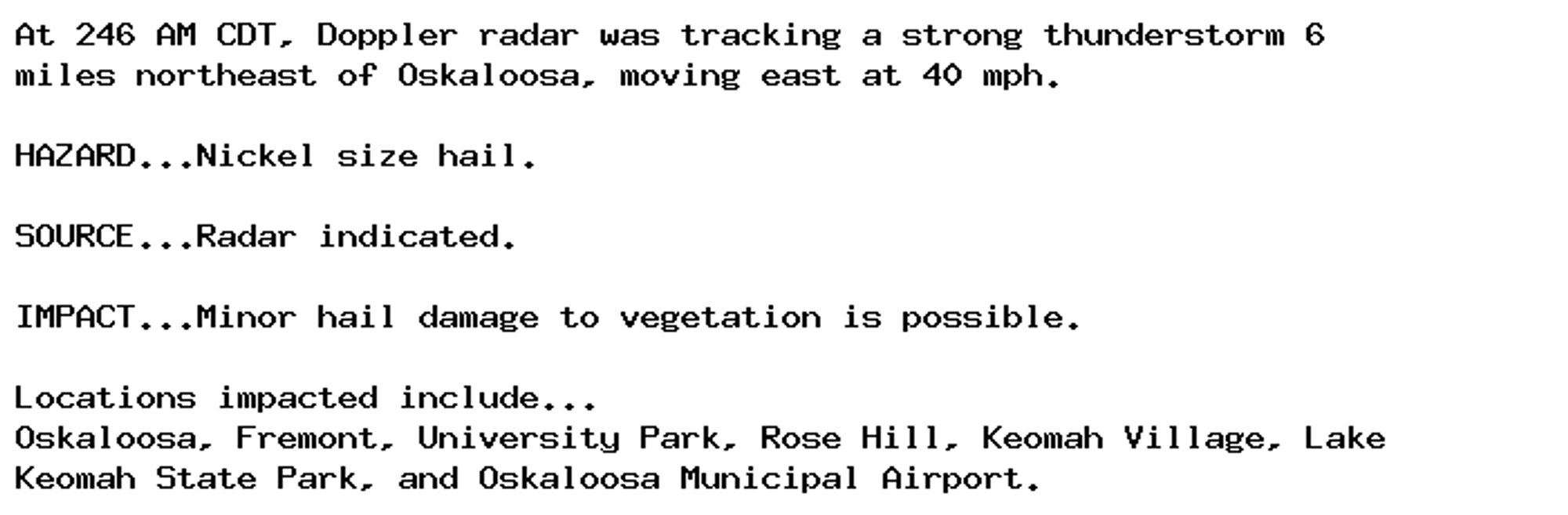
Special Weather Statement issued October 4 at 2:46AM CDT by NWS Des Moines IA Additional Details Here.

At 246 AM CDT, Doppler radar was tracking a strong thunderstorm 6
miles northeast of Oskaloosa, moving east at 40 mph.

HAZARD...Nickel size hail.

SOURCE...Radar indicated.

IMPACT...Minor hail damage to vegetation is possible.

Locations impacted include...
Oskaloosa, Fremont, University Park, Rose Hill, Keomah Village, Lake
Keomah State Park, and Oskaloosa Municipal Airport.
0
AFriw.nws-bot.us

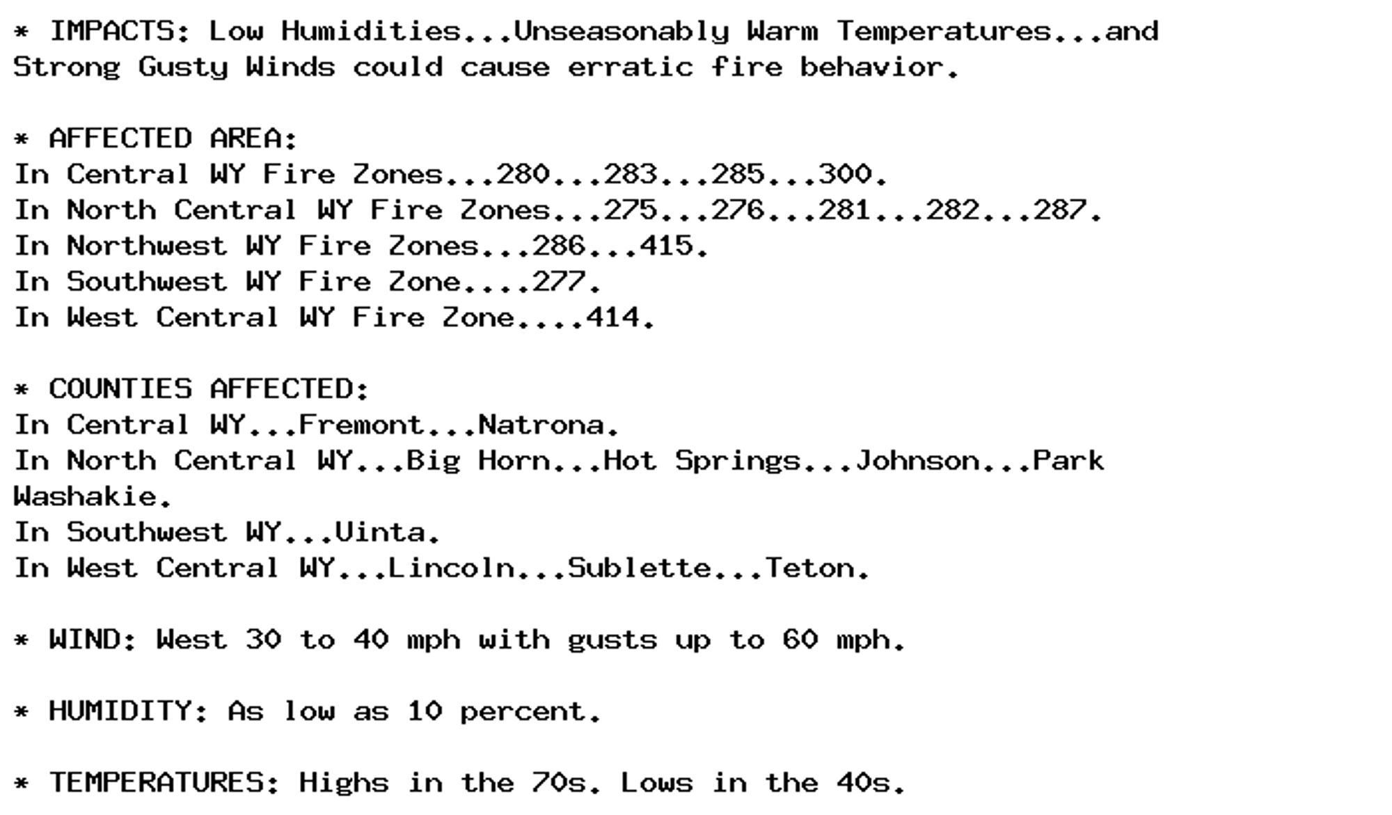
🚨 Red Flag Warning issued October 4 at 1:16AM MDT until October 5 at 9:00PM MDT by NWS Riverton WY 🚨 Additional Details Here.

* AFFECTED AREA:
In Central WY Fire Zones...288...289.
In Southwest WY Fire Zone....279.
In West Central WY Fire Zones...278...416.

* COUNTIES AFFECTED:
In Central WY...Fremont...Natrona.
In Southwest WY...Sweetwater.
In West Central WY...Lincoln...Sublette.

* IMPACTS: Low Humidities...Unseasonably Warm Temperatures...and
Strong Gusty Winds could cause erratic fire behavior.

* WIND: West 30 to 40 mph with gusts up to 60 mph.

* HUMIDITY: As low as 10 percent.

* TEMPERATURES: Highs in the 70s. Lows in the 40s.
0
AFriw.nws-bot.us

🚨 Red Flag Warning issued October 4 at 1:16AM MDT until October 5 at 7:00PM MDT by NWS Riverton WY 🚨 Additional Details Here.

* IMPACTS: Low Humidities...Unseasonably Warm Temperatures...and
Strong Gusty Winds could cause erratic fire behavior.

* AFFECTED AREA:
In Central WY Fire Zones...280...283...285...300.
In North Central WY Fire Zones...275...276...281...282...287.
In Northwest WY Fire Zones...286...415.
In Southwest WY Fire Zone....277.
In West Central WY Fire Zone....414.

* COUNTIES AFFECTED:
In Central WY...Fremont...Natrona.
In North Central WY...Big Horn...Hot Springs...Johnson...Park
Washakie.
In Southwest WY...Uinta.
In West Central WY...Lincoln...Sublette...Teton.

* WIND: West 30 to 40 mph with gusts up to 60 mph.

* HUMIDITY: As low as 10 percent.

* TEMPERATURES: Highs in the 70s. Lows in the 40s.
0