BLUE
HWhamiltonweather.ca

Tomorrow: Breezy with some sun, then turning cloudy, an afternoon thunderstorm in parts of the area, thunderstorms can bring hail and damaging winds. High 22C. Winds SW 20-50 km/h. Chance of rain 55%. Rainfall near 8mm. #HamOnt

0
AFeyw.nws-bot.us

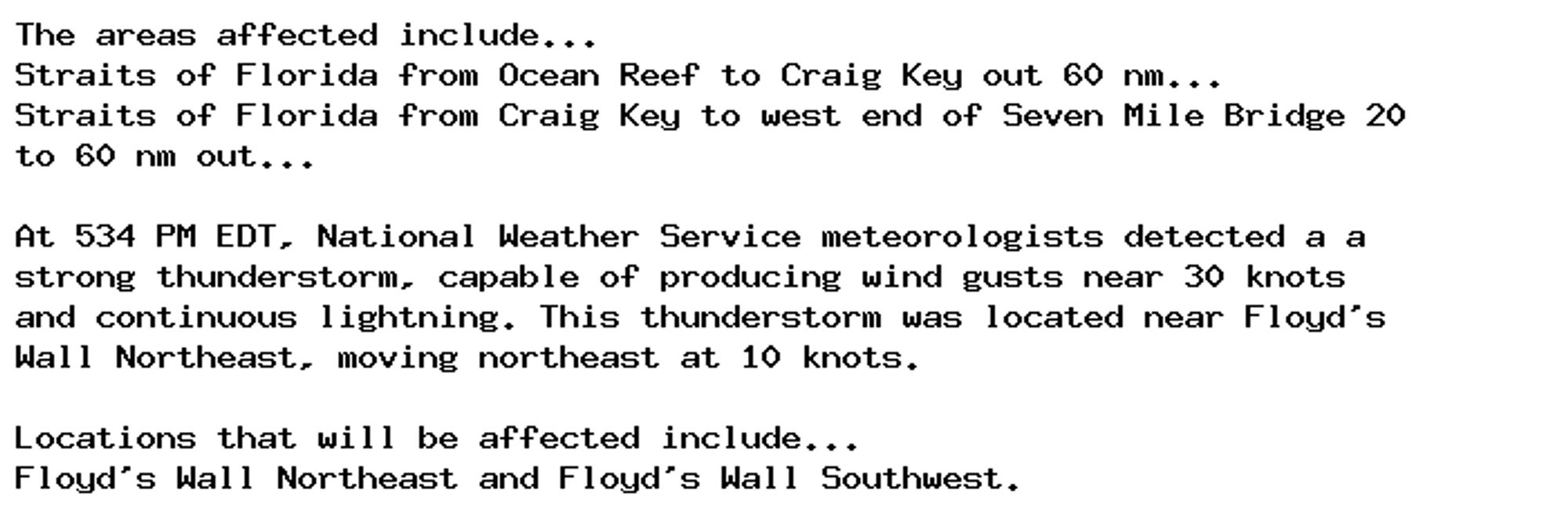
Marine Weather Statement issued October 5 at 5:35PM EDT by NWS Key West FL Additional Details Here.

The areas affected include...
Straits of Florida from Ocean Reef to Craig Key out 60 nm...
Straits of Florida from Craig Key to west end of Seven Mile Bridge 20
to 60 nm out...

At 534 PM EDT, National Weather Service meteorologists detected a a
strong thunderstorm, capable of producing wind gusts near 30 knots
and continuous lightning. This thunderstorm was located near Floyd's
Wall Northeast, moving northeast at 10 knots.

Locations that will be affected include...
Floyd's Wall Northeast and Floyd's Wall Southwest.
0
Sellyzoe.bsky.social

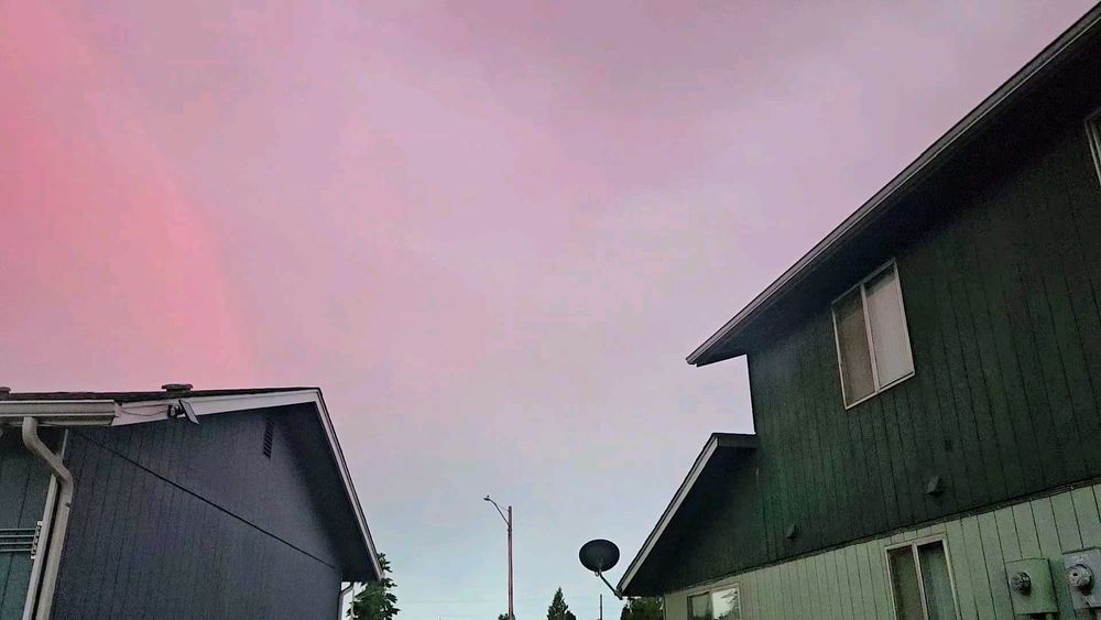
Dreamy porch and looks like relaxing weather. Storms later? I love a good porch sit in a thunderstorm. I miss them out here!

1
THahafoka.bsky.social

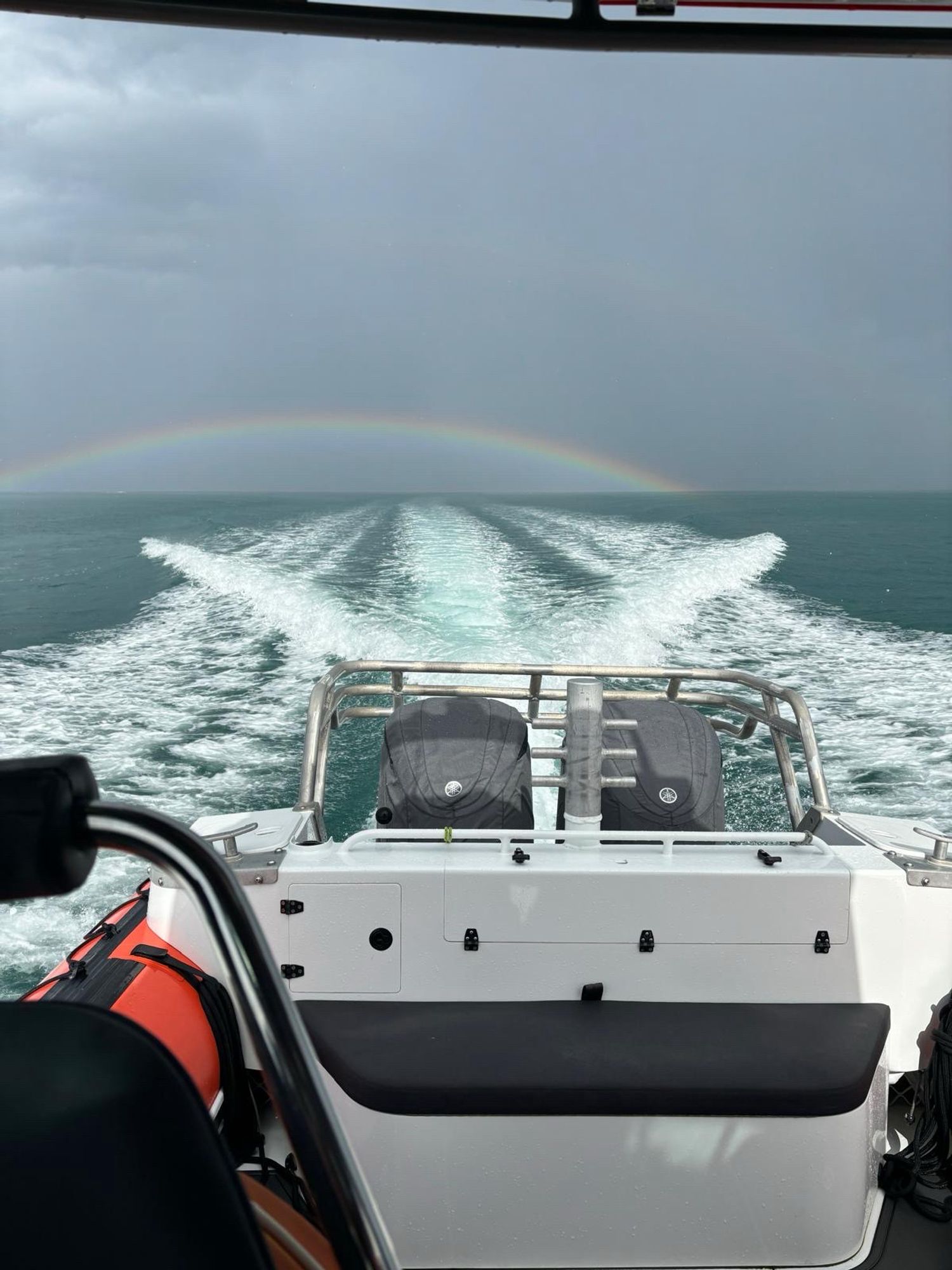
The weather did produce a rainbow or two. Here’s a pic taken from the Coastguard boat yesterday. The approaching thunderstorm helped create the rainbow.

View from the stern of Hibiscus Rescue 1 showing the twin outboards, boat wake and a rainbow in the approaching thunderstorm
0
STspc-storms.nws-bot.us

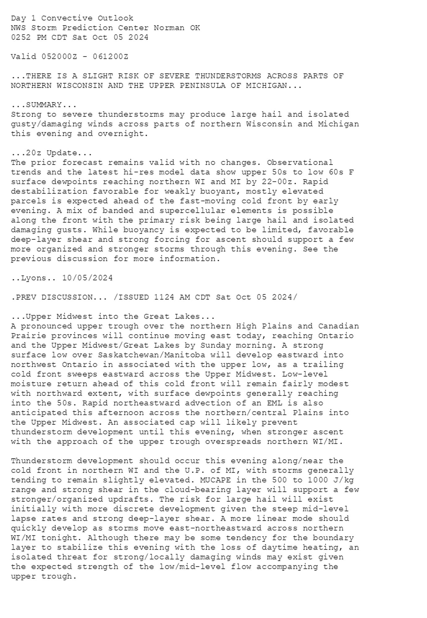
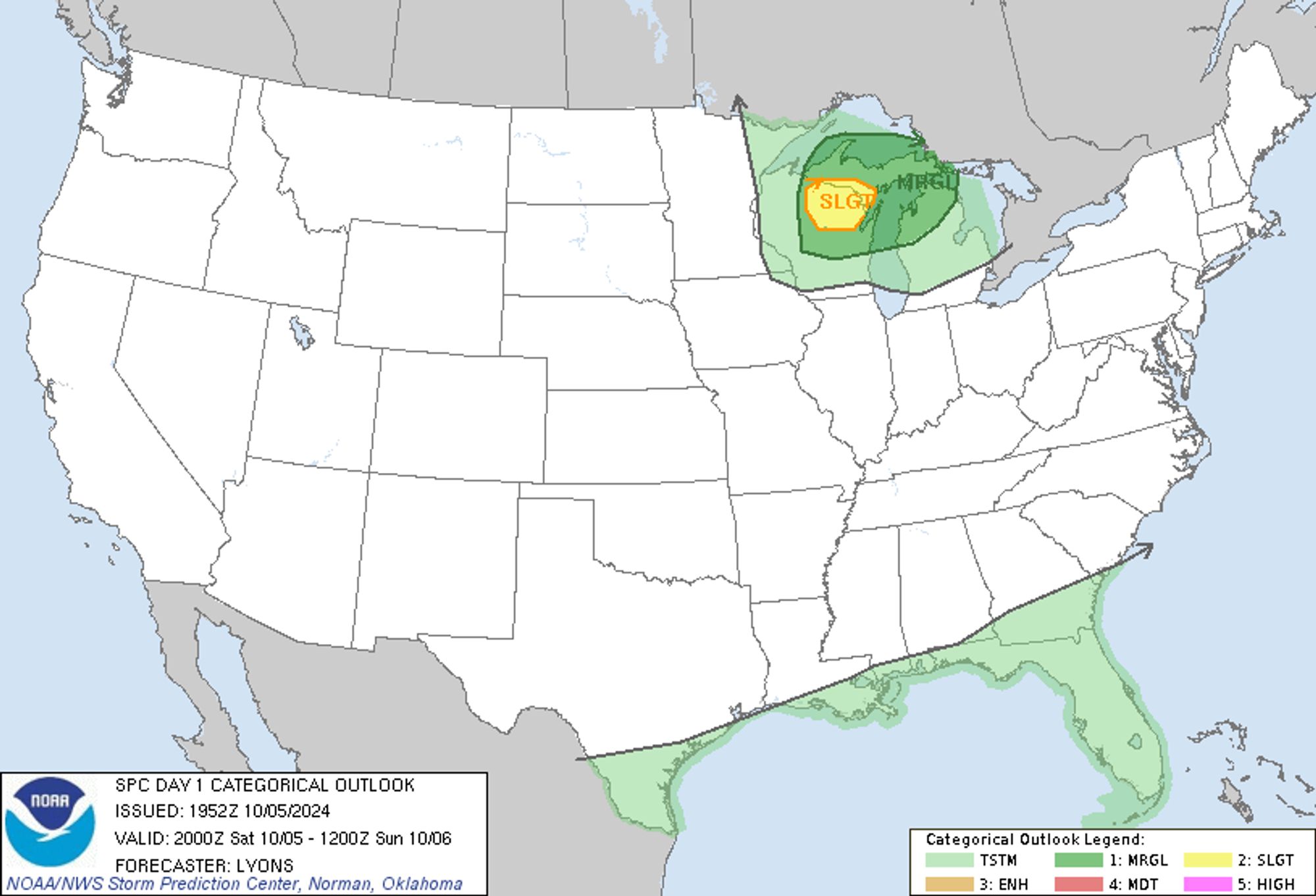
SPC Oct 5, 2024 2000 UTC Day 1 Convective Outlook ⛈️THERE IS A SLIGHT RISK OF SEVERE THUNDERSTORMS ACROSS PARTS OF NORTHERN WISCONSIN AND THE UPPER PENINSULA OF MICHIGAN🌪️ Additional Details Here.


Day 1 Convective Outlook  
NWS Storm Prediction Center Norman OK
0252 PM CDT Sat Oct 05 2024

Valid 052000Z - 061200Z

...THERE IS A SLIGHT RISK OF SEVERE THUNDERSTORMS ACROSS PARTS OF
NORTHERN WISCONSIN AND THE UPPER PENINSULA OF MICHIGAN...

...SUMMARY...
Strong to severe thunderstorms may produce large hail and isolated
gusty/damaging winds across parts of northern Wisconsin and Michigan
this evening and overnight.

...20z Update...
The prior forecast remains valid with no changes. Observational
trends and the latest hi-res model data show upper 50s to low 60s F
surface dewpoints reaching northern WI and MI by 22-00z. Rapid
destabilization favorable for weakly buoyant, mostly elevated
parcels is expected ahead of the fast-moving cold front by early
evening. A mix of banded and supercellular elements is possible
along the front with the primary risk being large hail and isolated
damaging gusts. While buoyancy is expected to be limited, favorable
deep-layer shear and strong forcing for ascent should support a few
more organized and stronger storms through this evening. See the
previous discussion for more information.

..Lyons.. 10/05/2024

.PREV DISCUSSION... /ISSUED 1124 AM CDT Sat Oct 05 2024/

...Upper Midwest into the Great Lakes...
A pronounced upper trough over the northern High Plains and Canadian
Prairie provinces will continue moving east today, reaching Ontario
and the Upper Midwest/Great Lakes by Sunday morning. A strong
surface low over Saskatchewan/Manitoba will develop eastward into
northwest Ontario in associated with the upper low, as a trailing
cold front sweeps eastward across the Upper Midwest. Low-level
moisture return ahead of this cold front will remain fairly modest
with northward extent, with surface dewpoints generally reaching
into the 50s. Rapid northeastward advection of an EML is also
anticipated this afternoon across the northern/central Plains into
the Upper Midwest. An associated cap will likely prevent
thunderstorm development until this evening, when stronger ascent
with the approach of the upper trough overspreads northern WI/MI.

Thunderstorm development should occur this evening along/near the
cold front in northern WI and the U.P. of MI, with storms generally
tending to remain slightly elevated. MUCAPE in the 500 to 1000 J/kg
range and strong shear in the cloud-bearing layer will support a few
stronger/organized updrafts. The risk for large hail will exist
initially with more discrete development given the steep mid-level
lapse rates and strong deep-layer shear. A more linear mode should
quickly develop as storms move east-northeastward across northern
WI/MI tonight. Although there may be some tendency for the boundary
layer to stabilize this evening with the loss of daytime heating, an
isolated threat for strong/locally damaging winds may exist given
the expected strength of the low/mid-level flow accompanying the
upper trough.
Day 1 Outlook Image
0
NCnwschicago.bsky.social

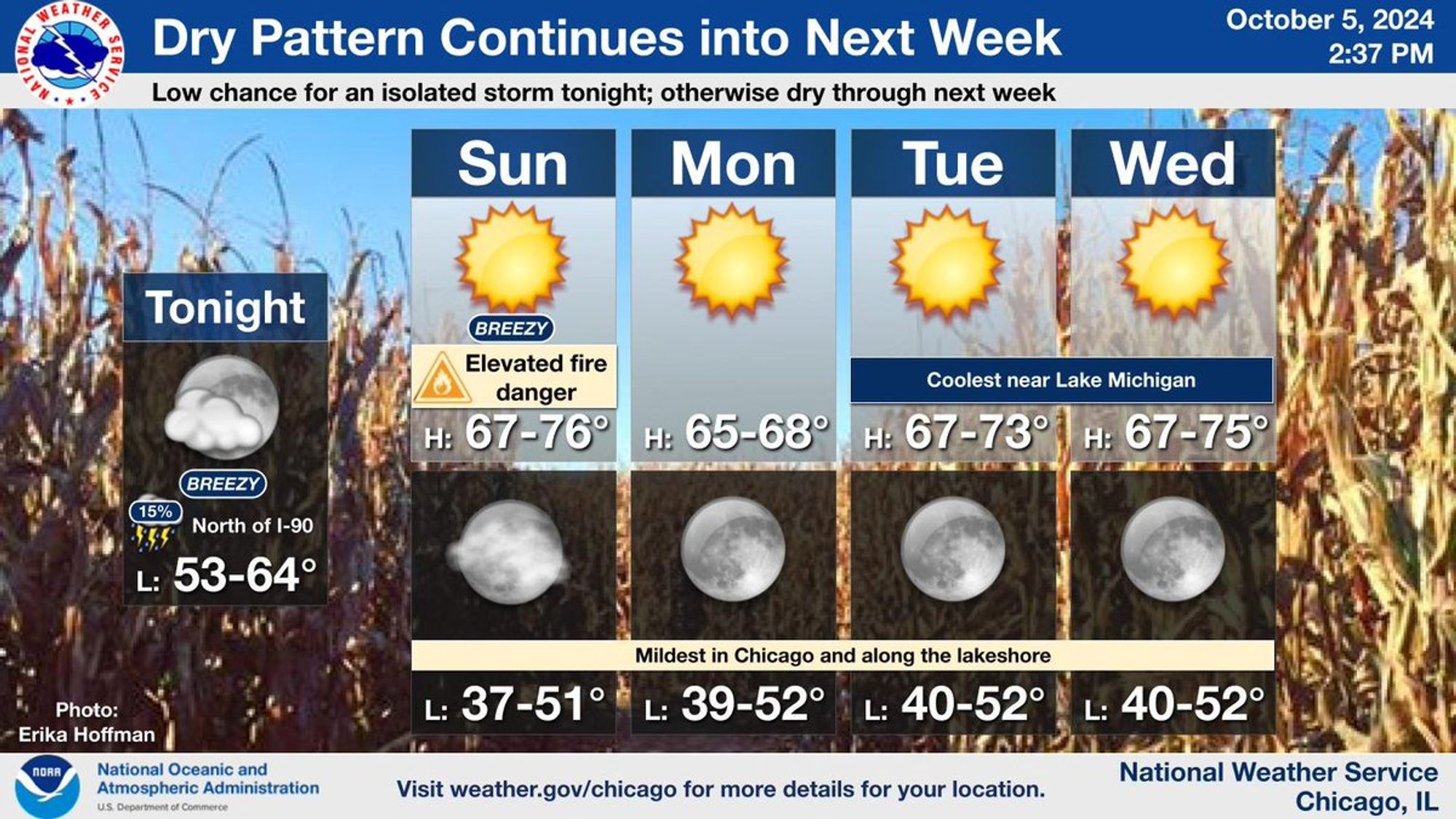
On Sunday, continued warmth with lower humidity levels and breezy conditions will bring an elevated threat that grass and brush fires may start and spread. Outside of a low chance for an isolated thunderstorm north of I-90 late tonight, no precipitation is expected next week.

This is a multiday forecast graphic for northern Illinois and northwest Indiana.  Headline: Dry Pattern Continues into Next Week.  Sub Headline: Low chance for an isolated storm tonight; otherwise dry through next week.  Visit weather.gov/Chicago for more forecast details for your location.    Graphic Created: Saturday, October 5, 2024 2:29 PM CDT
0
Mrincewind.run

when flying kites in a thunderstorm is the least weird thing you do

3
STspc-storms.nws-bot.us

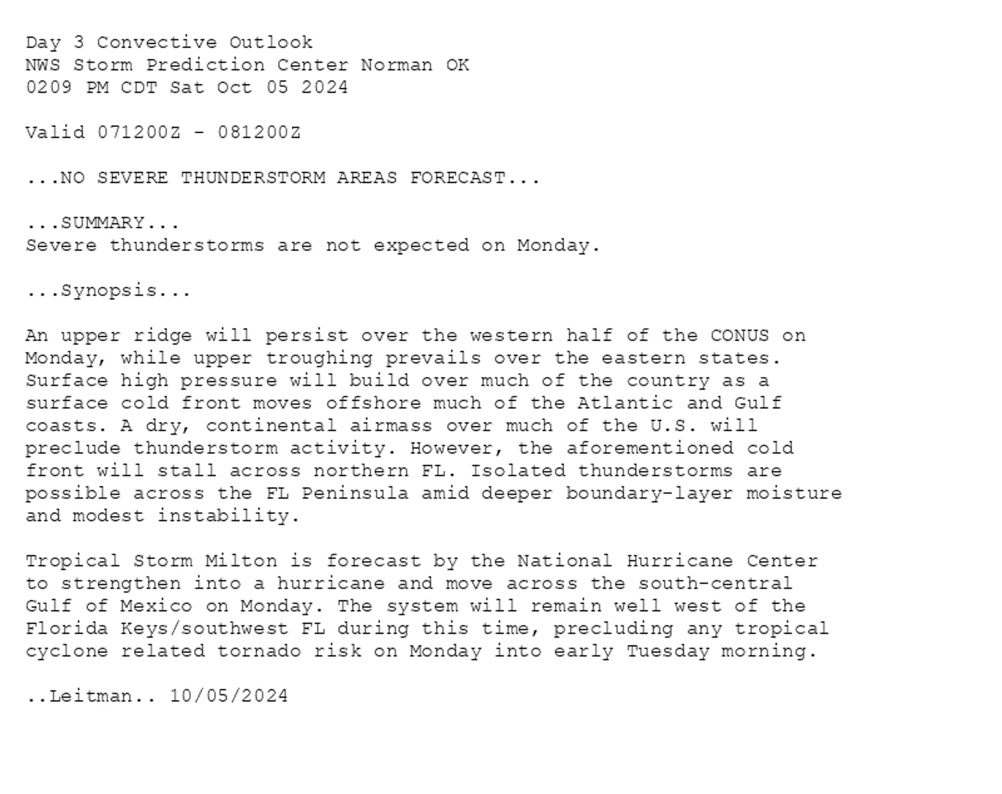
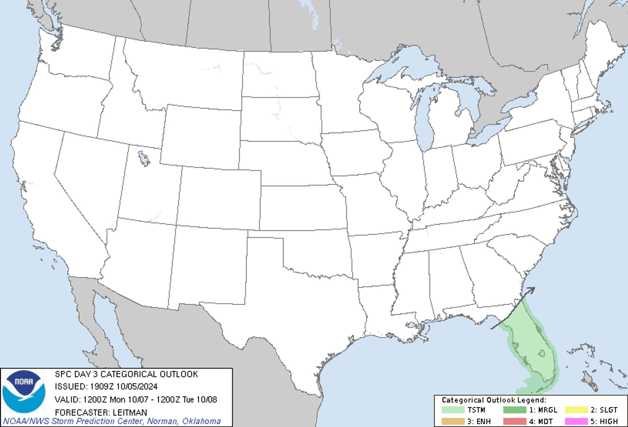
SPC Oct 5, 2024 1930 UTC Day 3 Severe Thunderstorm Outlook ⛈️NO SEVERE THUNDERSTORM AREAS FORECAST🌪️ Additional Details Here.


Day 3 Convective Outlook  
NWS Storm Prediction Center Norman OK
0209 PM CDT Sat Oct 05 2024

Valid 071200Z - 081200Z

...NO SEVERE THUNDERSTORM AREAS FORECAST...

...SUMMARY...
Severe thunderstorms are not expected on Monday.

...Synopsis...

An upper ridge will persist over the western half of the CONUS on
Monday, while upper troughing prevails over the eastern states.
Surface high pressure will build over much of the country as a
surface cold front moves offshore much of the Atlantic and Gulf
coasts. A dry, continental airmass over much of the U.S. will
preclude thunderstorm activity. However, the aforementioned cold
front will stall across northern FL. Isolated thunderstorms are
possible across the FL Peninsula amid deeper boundary-layer moisture
and modest instability. 

Tropical Storm Milton is forecast by the National Hurricane Center
to strengthen into a hurricane and move across the south-central
Gulf of Mexico on Monday. The system will remain well west of the
Florida Keys/southwest FL during this time, precluding any tropical
cyclone related tornado risk on Monday into early Tuesday morning.

..Leitman.. 10/05/2024
Day 3 Outlook Image
0
AFsju.nws-bot.us

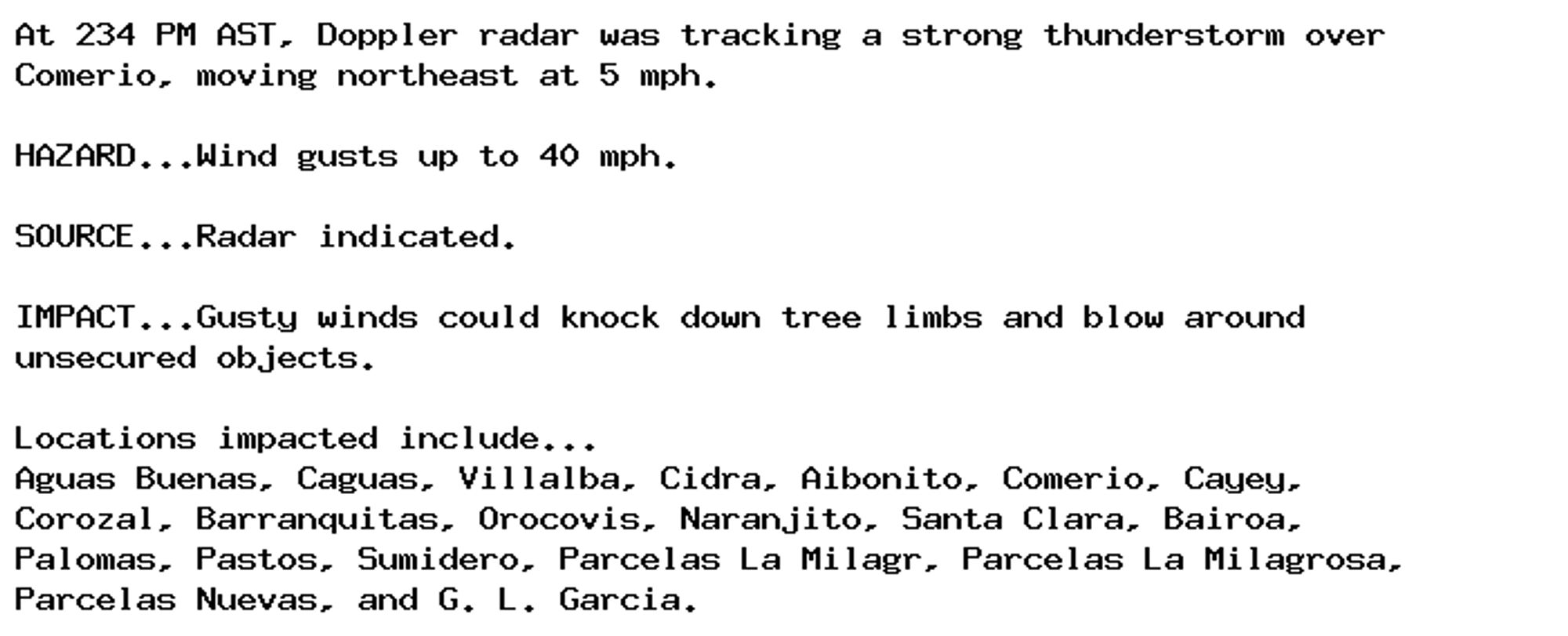
Special Weather Statement issued October 5 at 2:34PM AST by NWS San Juan PR Additional Details Here.

At 234 PM AST, Doppler radar was tracking a strong thunderstorm over
Comerio, moving northeast at 5 mph.

HAZARD...Wind gusts up to 40 mph.

SOURCE...Radar indicated.

IMPACT...Gusty winds could knock down tree limbs and blow around
unsecured objects.

Locations impacted include...
Aguas Buenas, Caguas, Villalba, Cidra, Aibonito, Comerio, Cayey,
Corozal, Barranquitas, Orocovis, Naranjito, Santa Clara, Bairoa,
Palomas, Pastos, Sumidero, Parcelas La Milagr, Parcelas La Milagrosa,
Parcelas Nuevas, and G. L. Garcia.
0