BLUE
AFwas.nws-bot.us

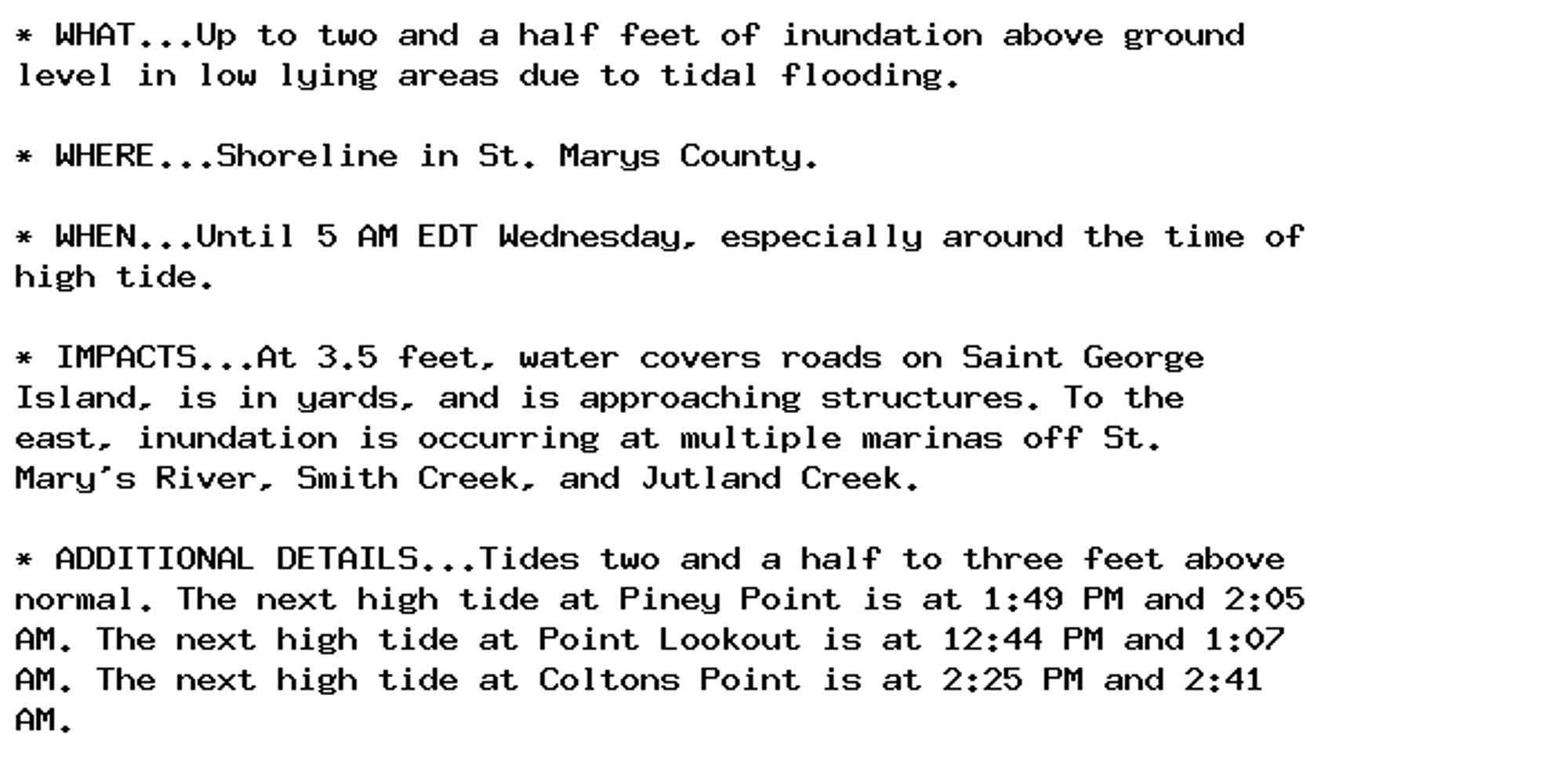
Coastal Flood Advisory issued September 30 at 11:29AM EDT until October 2 at 5:00AM EDT by NWS Baltimore MD/Washington DC Additional Details Here.

* WHAT...Up to two and a half feet of inundation above ground
level in low lying areas due to tidal flooding.

* WHERE...Shoreline in St. Marys County.

* WHEN...Until 5 AM EDT Wednesday, especially around the time of
high tide.

* IMPACTS...At 3.5 feet, water covers roads on Saint George
Island, is in yards, and is approaching structures. To the
east, inundation is occurring at multiple marinas off St.
Mary's River, Smith Creek, and Jutland Creek.

* ADDITIONAL DETAILS...Tides two and a half to three feet above
normal. The next high tide at Piney Point is at 1:49 PM and 2:05
AM. The next high tide at Point Lookout is at 12:44 PM and 1:07
AM. The next high tide at Coltons Point is at 2:25 PM and 2:41
AM.
0
MMmartinmckee.bsky.social

While stressing that I'm not referring to anyone in particular, maybe if they didn't fix it before we need others who would be more successful. But I would also argue that we must fix the governance structures before appointing someone new.

0
JBjeboyt.bsky.social

Right, and we built the structures. So, we can change them.

0
NFnews-feed.bsky.social

@AJEnglish: '163,778 structures' Very high-resolution imagery collected on September 3 and 6 showed two-thirds of the total structures in besieged Gaza were damaged, says UN Satellite Centre (UNOSAT). 🔴 LIVE updates: https://t.co/EkJxIdsYYs

0
AFwas.nws-bot.us

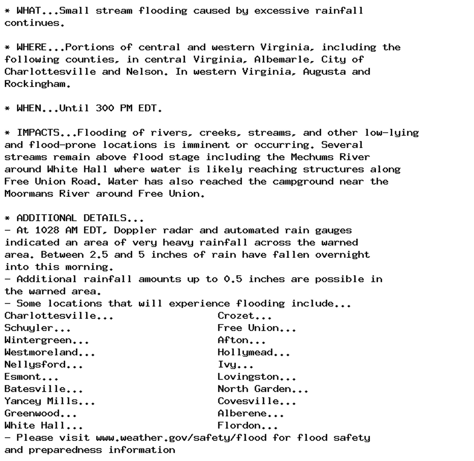
🚨 Flood Warning issued September 30 at 10:30AM EDT until September 30 at 3:00PM EDT by NWS Baltimore MD/Washington DC 🚨 Additional Details Here.

* WHAT...Small stream flooding caused by excessive rainfall
continues.

* WHERE...Portions of central and western Virginia, including the
following counties, in central Virginia, Albemarle, City of
Charlottesville and Nelson. In western Virginia, Augusta and
Rockingham.

* WHEN...Until 300 PM EDT.

* IMPACTS...Flooding of rivers, creeks, streams, and other low-lying
and flood-prone locations is imminent or occurring. Several
streams remain above flood stage including the Mechums River
around White Hall where water is likely reaching structures along
Free Union Road. Water has also reached the campground near the
Moormans River around Free Union.

* ADDITIONAL DETAILS...
- At 1028 AM EDT, Doppler radar and automated rain gauges
indicated an area of very heavy rainfall across the warned
area. Between 2.5 and 5 inches of rain have fallen overnight
into this morning.
- Additional rainfall amounts up to 0.5 inches are possible in
the warned area.
- Some locations that will experience flooding include...
Charlottesville...                 Crozet...
Schuyler...                        Free Union...
Wintergreen...                     Afton...
Westmoreland...                    Hollymead...
Nellysford...                      Ivy...
Esmont...                          Lovingston...
Batesville...                      North Garden...
Yancey Mills...                    Covesville...
Greenwood...                       Alberene...
White Hall...                      Flordon...
- Please visit www.weather.gov/safety/flood for flood safety
and preparedness information
0
AFwas.nws-bot.us

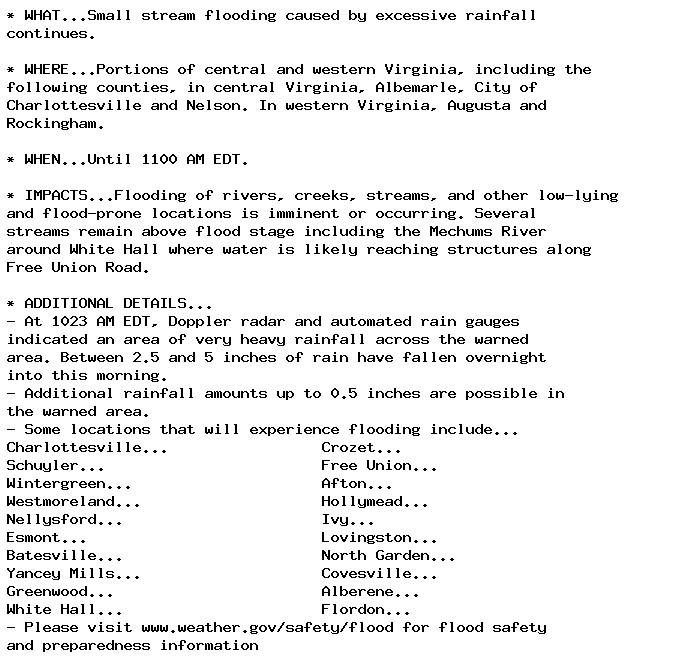
🚨 Flood Warning issued September 30 at 10:28AM EDT until September 30 at 11:00AM EDT by NWS Baltimore MD/Washington DC 🚨 Additional Details Here.

* WHAT...Small stream flooding caused by excessive rainfall
continues.

* WHERE...Portions of central and western Virginia, including the
following counties, in central Virginia, Albemarle, City of
Charlottesville and Nelson. In western Virginia, Augusta and
Rockingham.

* WHEN...Until 1100 AM EDT.

* IMPACTS...Flooding of rivers, creeks, streams, and other low-lying
and flood-prone locations is imminent or occurring. Several
streams remain above flood stage including the Mechums River
around White Hall where water is likely reaching structures along
Free Union Road.

* ADDITIONAL DETAILS...
- At 1023 AM EDT, Doppler radar and automated rain gauges
indicated an area of very heavy rainfall across the warned
area. Between 2.5 and 5 inches of rain have fallen overnight
into this morning.
- Additional rainfall amounts up to 0.5 inches are possible in
the warned area.
- Some locations that will experience flooding include...
Charlottesville...                 Crozet...
Schuyler...                        Free Union...
Wintergreen...                     Afton...
Westmoreland...                    Hollymead...
Nellysford...                      Ivy...
Esmont...                          Lovingston...
Batesville...                      North Garden...
Yancey Mills...                    Covesville...
Greenwood...                       Alberene...
White Hall...                      Flordon...
- Please visit www.weather.gov/safety/flood for flood safety
and preparedness information
0
HNhollynielsen.bsky.social

Depends entirely on the project! There’s no one size fits all If it’s a more classic “world” then it’s helpful that the mundane is noted, not just the exceptional. Population, food sources, societal structures, methods of storytelling etc. Not just “here’s a list of Big Names & Big Events”

3
Aalhadis.bsky.social

Yeah, but sigils enable you to do grouse shit like `%dict = /^\h*((?!\s)[^:]+)\h*:\h*(.*)$/gm` or `@lines = <>`. I understand how accessing nested data structures can be annoying, however.

0
MMmartinmckee.bsky.social

2/2 Today the chair of the College’s Board of Trustees resigned, an important step but there is still some way to go. Above all we need to be able to say who is accountable to whom for what. Governance structures are actually rather important www.rcp.ac.uk/news-and-med...

Chair of the Royal College of Physicians (RCP) board of trustees steps down

0