BLUE
pictimo.bsky.social

0255

0
SGstevegoodhand.bsky.social

LATEST NEWS ...NOW AVAILABLE Hull Investment Property Limited Price: £110,000 Type: Large 3 Bed BTL / 2 Reception Rooms (Possible HMO) Works: Some Upgrade Required Status: Currently Vacant Location: Hull HU5 hullip.co.uk/property/0255/#hull#stevegoodhand#investment#property#investors#forsale

0
kagura-duki.bsky.social

【Auto Post 0255】 酒乱に陥った人がものを壊した事実や他人を傷付けた事実は、絶対になかった事にしてはいけません。 自分が酔っぱらった上に何をしでかしてしまったのか。 それを自身に自覚してもらわない限り、事態の好転などありえません。

0
STspc-storms.nws-bot.us

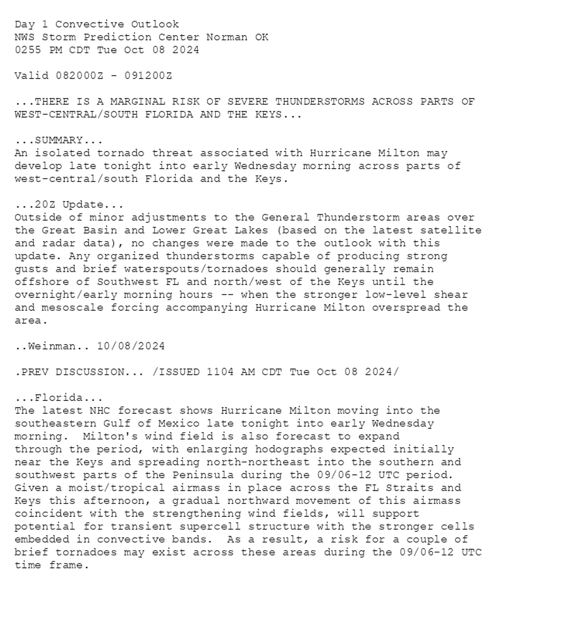
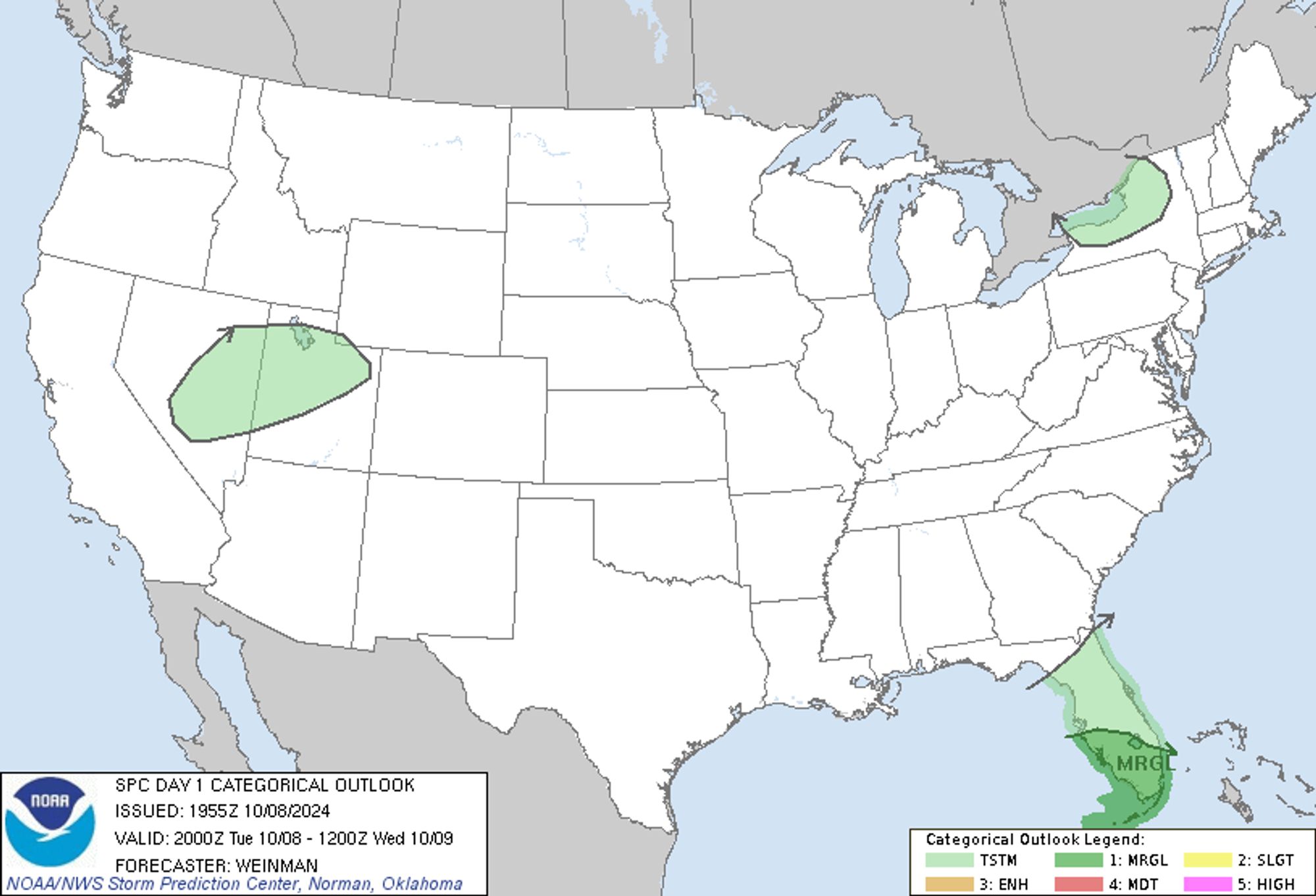
SPC Oct 8, 2024 2000 UTC Day 1 Convective Outlook ⛈️THERE IS A MARGINAL RISK OF SEVERE THUNDERSTORMS ACROSS PARTS OF WEST-CENTRAL/SOUTH FLORIDA AND THE KEYS🌪️ Additional Details Here.


Day 1 Convective Outlook  
NWS Storm Prediction Center Norman OK
0255 PM CDT Tue Oct 08 2024

Valid 082000Z - 091200Z

...THERE IS A MARGINAL RISK OF SEVERE THUNDERSTORMS ACROSS PARTS OF
WEST-CENTRAL/SOUTH FLORIDA AND THE KEYS...

...SUMMARY...
An isolated tornado threat associated with Hurricane Milton may
develop late tonight into early Wednesday morning across parts of
west-central/south Florida and the Keys.

...20Z Update...
Outside of minor adjustments to the General Thunderstorm areas over
the Great Basin and Lower Great Lakes (based on the latest satellite
and radar data), no changes were made to the outlook with this
update. Any organized thunderstorms capable of producing strong
gusts and brief waterspouts/tornadoes should generally remain
offshore of Southwest FL and north/west of the Keys until the
overnight/early morning hours -- when the stronger low-level shear
and mesoscale forcing accompanying Hurricane Milton overspread the
area.

..Weinman.. 10/08/2024

.PREV DISCUSSION... /ISSUED 1104 AM CDT Tue Oct 08 2024/

...Florida...
The latest NHC forecast shows Hurricane Milton moving into the
southeastern Gulf of Mexico late tonight into early Wednesday
morning.  Milton's wind field is also forecast to expand
through the period, with enlarging hodographs expected initially
near the Keys and spreading north-northeast into the southern and
southwest parts of the Peninsula during the 09/06-12 UTC period. 
Given a moist/tropical airmass in place across the FL Straits and
Keys this afternoon, a gradual northward movement of this airmass
coincident with the strengthening wind fields, will support
potential for transient supercell structure with the stronger cells
embedded in convective bands.  As a result, a risk for a couple of
brief tornadoes may exist across these areas during the 09/06-12 UTC
time frame.
Day 1 Outlook Image
0
STspc-storms.nws-bot.us

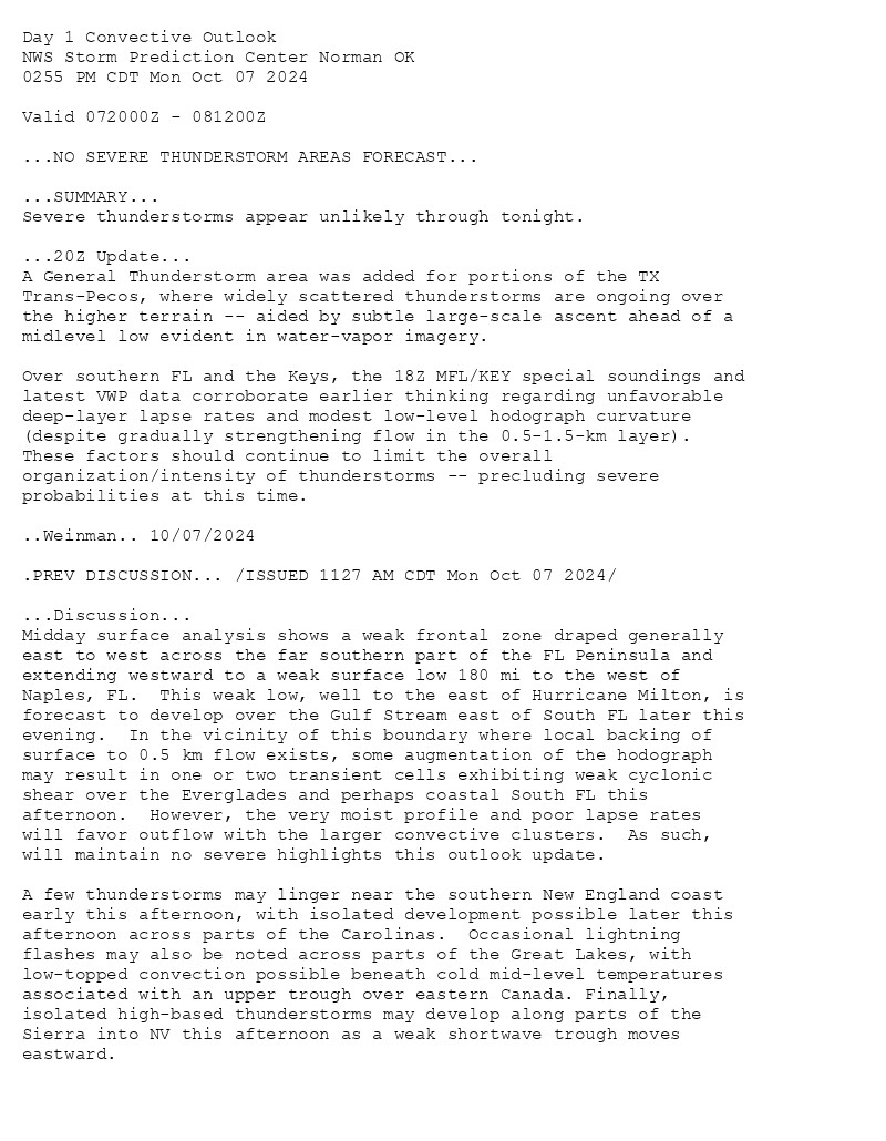
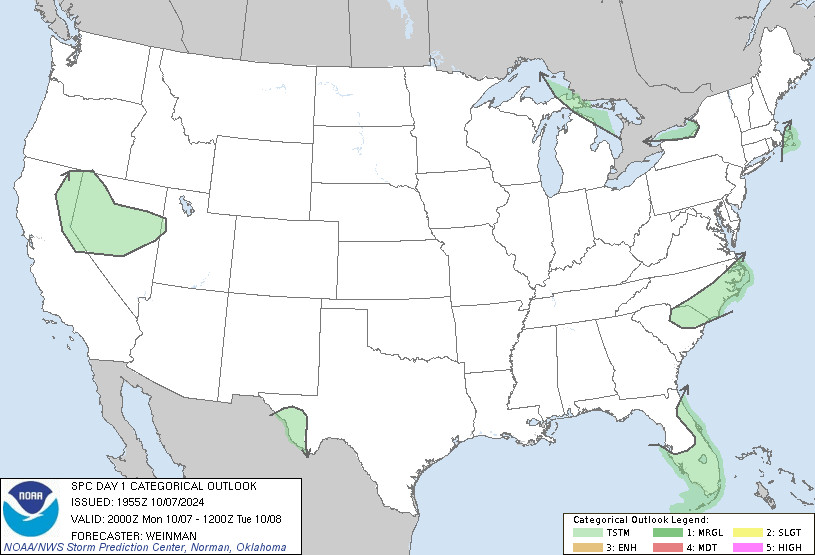
SPC Oct 7, 2024 2000 UTC Day 1 Convective Outlook ⛈️NO SEVERE THUNDERSTORM AREAS FORECAST🌪️ Additional Details Here.


Day 1 Convective Outlook  
NWS Storm Prediction Center Norman OK
0255 PM CDT Mon Oct 07 2024

Valid 072000Z - 081200Z

...NO SEVERE THUNDERSTORM AREAS FORECAST...

...SUMMARY...
Severe thunderstorms appear unlikely through tonight.

...20Z Update...
A General Thunderstorm area was added for portions of the TX
Trans-Pecos, where widely scattered thunderstorms are ongoing over
the higher terrain -- aided by subtle large-scale ascent ahead of a
midlevel low evident in water-vapor imagery. 

Over southern FL and the Keys, the 18Z MFL/KEY special soundings and
latest VWP data corroborate earlier thinking regarding unfavorable
deep-layer lapse rates and modest low-level hodograph curvature
(despite gradually strengthening flow in the 0.5-1.5-km layer).
These factors should continue to limit the overall
organization/intensity of thunderstorms -- precluding severe
probabilities at this time.

..Weinman.. 10/07/2024

.PREV DISCUSSION... /ISSUED 1127 AM CDT Mon Oct 07 2024/

...Discussion...
Midday surface analysis shows a weak frontal zone draped generally
east to west across the far southern part of the FL Peninsula and
extending westward to a weak surface low 180 mi to the west of
Naples, FL.  This weak low, well to the east of Hurricane Milton, is
forecast to develop over the Gulf Stream east of South FL later this
evening.  In the vicinity of this boundary where local backing of
surface to 0.5 km flow exists, some augmentation of the hodograph
may result in one or two transient cells exhibiting weak cyclonic
shear over the Everglades and perhaps coastal South FL this
afternoon.  However, the very moist profile and poor lapse rates
will favor outflow with the larger convective clusters.  As such,
will maintain no severe highlights this outlook update.

A few thunderstorms may linger near the southern New England coast
early this afternoon, with isolated development possible later this
afternoon across parts of the Carolinas.  Occasional lightning
flashes may also be noted across parts of the Great Lakes, with
low-topped convection possible beneath cold mid-level temperatures
associated with an upper trough over eastern Canada. Finally,
isolated high-based thunderstorms may develop along parts of the
Sierra into NV this afternoon as a weak shortwave trough moves
eastward.
Day 1 Outlook Image
0
FMhrfm.bsky.social

Udflugt #0255 - Wilhelm Freddie - Psykofotografisk fænomen: Sabotage (1944) - Kunsten, Aalborg
0
SGstevegoodhand.bsky.social

LATEST NEWS ... NEW INSTRUCTION Hull Investment Property Limited Price: £125,000 Deal: BTL / HMO Type: Large 3 Bed Location: Hull HU5 Property: 0255 hullip.co.uk/property/0255/#hull#stevegoodhand#investment#property#investors#btl#forsale#offmarket#sellwithus#d2v

0
kagura-duki.bsky.social

【Auto Post 0255】 酒乱に陥った人がものを壊した事実や他人を傷付けた事実は、絶対になかった事にしてはいけません。 自分が酔っぱらった上に何をしでかしてしまったのか。 それを自身に自覚してもらわない限り、事態の好転などありえません。

0
rymda6ck3128.bsky.social

0255:  今日からまた頑張ろう。  [投稿日:2024/9/16 (月)]

0
BJbikingjp.bsky.social

CBR1000RRで北海道ツーリング 2024 徒然単車日記[No.0255] バイク神社編・愛国駅〜幸福駅 https://www.bikingjp.com/492355/ CBR1000RRで北海道ツーリング 2024 徒然単車日記[No.0255] バイク神社編・愛国駅〜幸福駅 北海道北見発 徒然単車日記 2024年5月16日、毎年恒例にしているシーズン一番最初の十勝浦幌町にある北海道のバイク神社浦幌神社に参拝に行くツーリングです。 …

CBR1000RRで北海道ツーリング 2024 徒然単車日記 バイク神社編・愛国駅〜幸福駅

CBR1000RRで北海道ツーリング 2024 徒然単車日記 バイク神社編・愛国駅〜幸福駅北海道北見発 徒然単車日記2024年5月16日、毎年恒例にしているシーズン一番最初の十勝浦幌町にある北海道のバイク神社浦幌神社に参拝に行くツーリングです。今シーズンは北見市を出発、陸別町、足寄町、上士幌町、士幌町、鹿追町、音更町、帯広市、中札内村、更別村、幕別町、大樹町と経由、大樹町にある晩成温泉に一泊。二日目浦幌町、本別町、足寄町、陸別町を経由、北見市に戻るルートです。今回の総走行距離、二日間で571.7Km定番ですが愛国駅から幸福駅へ、こちらの同じく数十年振りに訪れました。こちらの方は知名度が結構高いのか観光客の数も愛国駅より多かったですね。2023年以前の過去動画の更新を諦めたわけではないのですが、なかなか追いつけない状況なので今シーズンは2024年分を優先してアップしていこうと思います。2024シーズンもよろしくお願いいたします。#幸福駅#北海道ツーリング#cbr1000rr

0