BLUE
HRhnrfineart.bsky.social

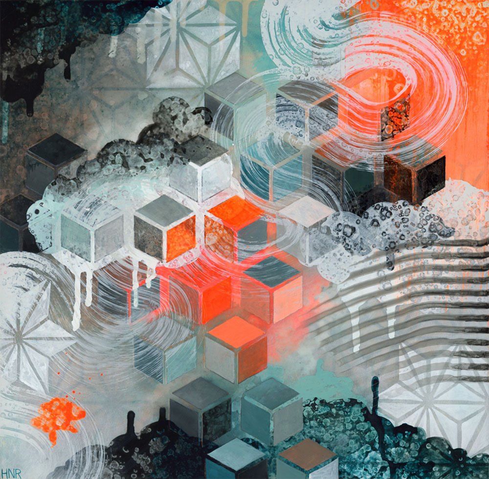
Almost ready for Open Studios this weekend! I know it's gonna be hottttt but I hope you'll come visit me at Arc, 1246 Folsom St SF. Fri 6-9pm, Sat & Sun 11am-5pm. Preview the new work online: heatherrobinson.com/private-prev...

Open Studios Preview — Fine Art by Heather Robinson

0

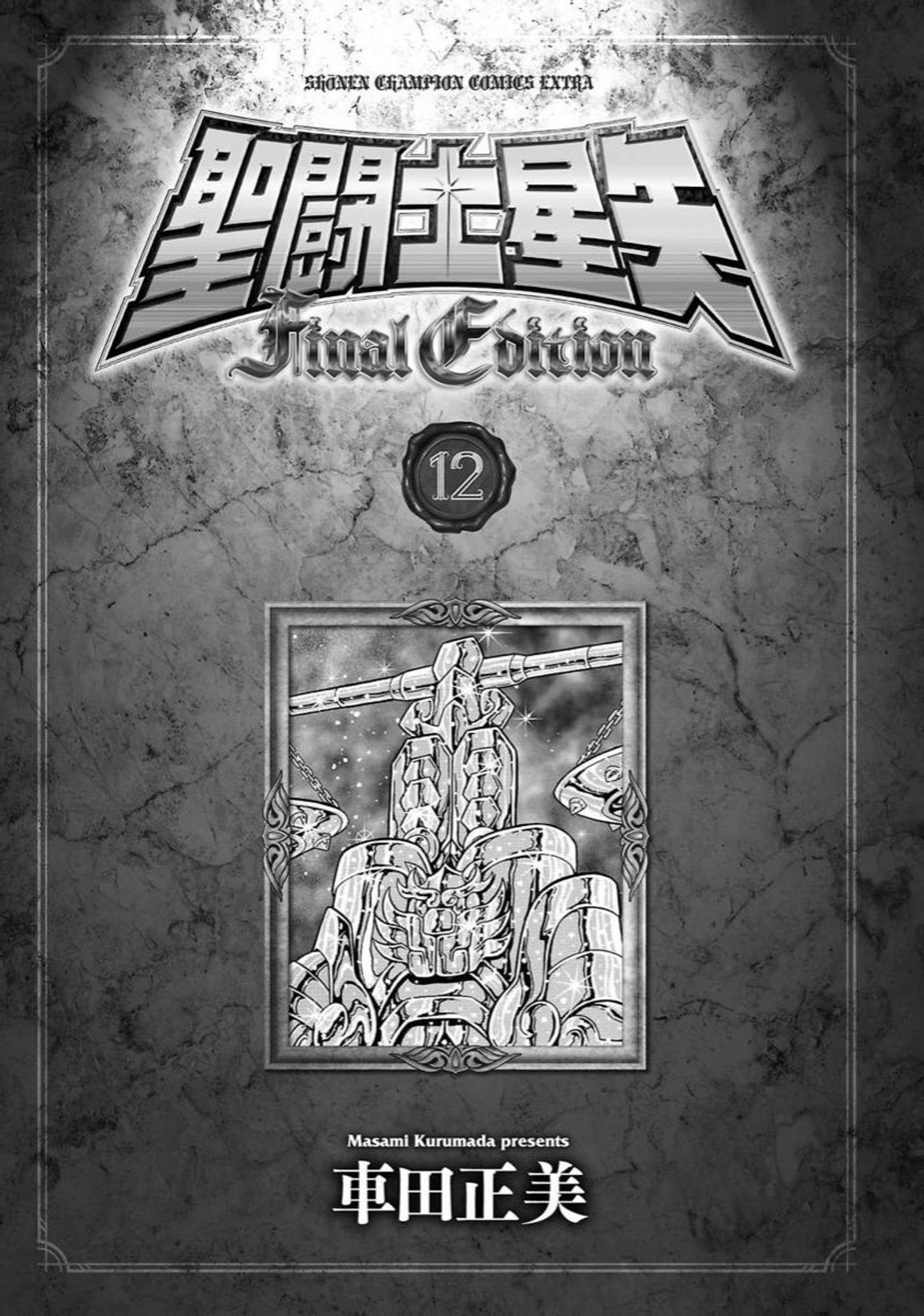
Confira a prévia da edição digital do volume 12 da Final Edition de Saint Seiya. santosdebronze.blogspot.com/2024/10/Prev...#FinalEdition#SaintSeiya

0
Ccam.fyi

“You’ll be interviewing with X person next. They love dogs. Drop the phrase “hypergrowth” to describe your prev job. If you’ve used nextjs, mention it in passing but don’t make a fuss about it. Here’s your interviewer’s OCEAN scores. You should flirt a little, but watch out”

1
STspc-storms.nws-bot.us

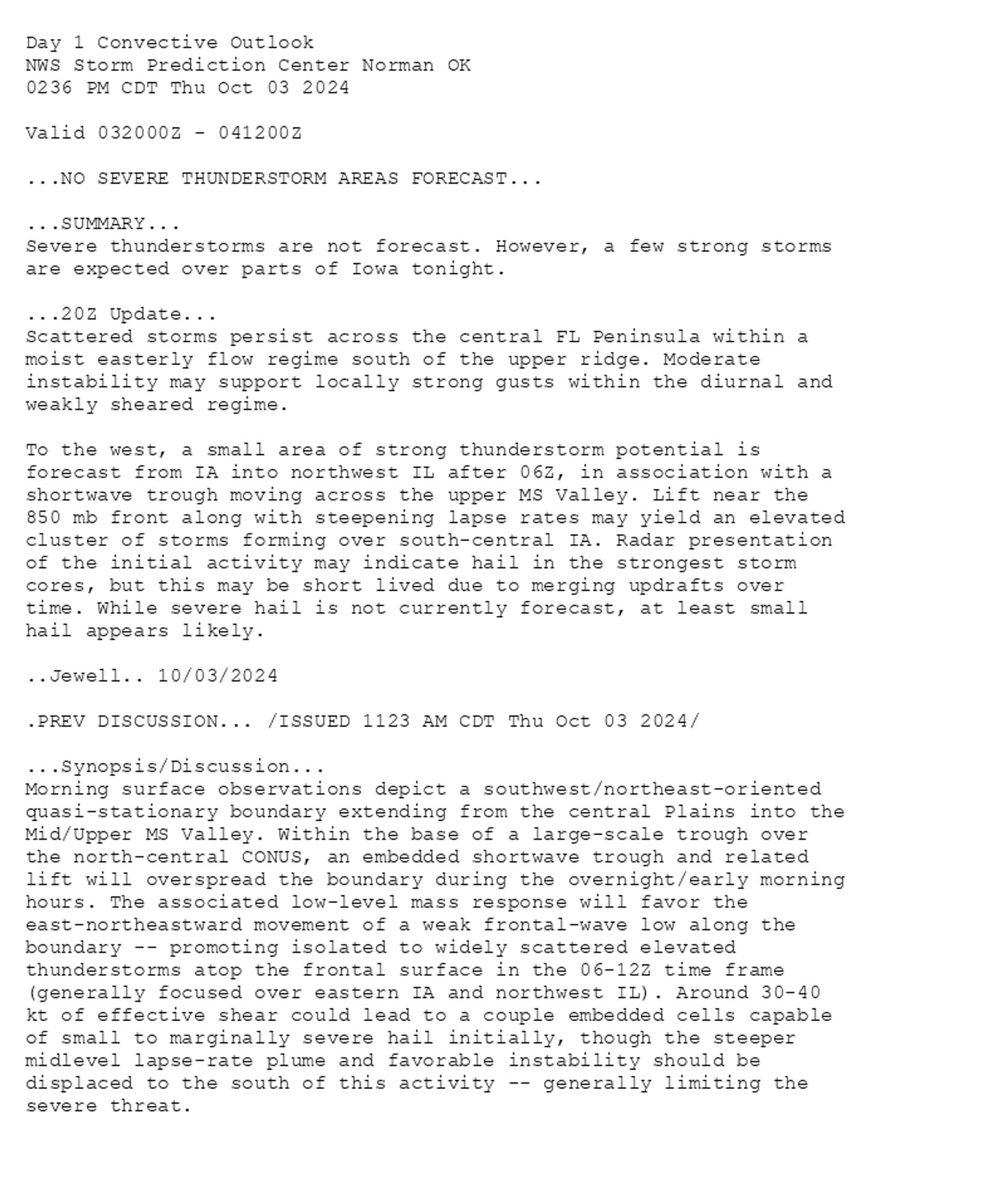
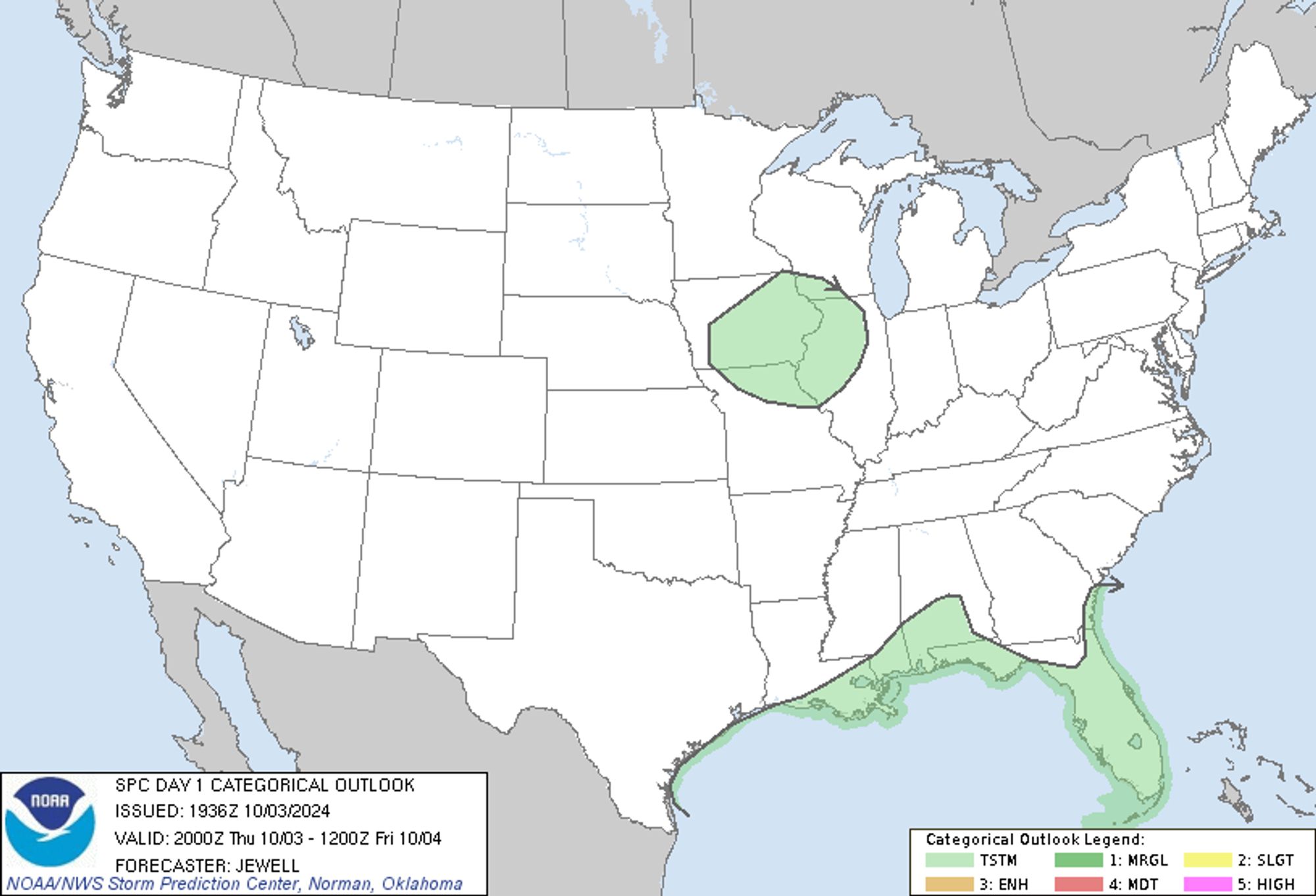
SPC Oct 3, 2024 2000 UTC Day 1 Convective Outlook ⛈️NO SEVERE THUNDERSTORM AREAS FORECAST🌪️ Additional Details Here.


Day 1 Convective Outlook  
NWS Storm Prediction Center Norman OK
0236 PM CDT Thu Oct 03 2024

Valid 032000Z - 041200Z

...NO SEVERE THUNDERSTORM AREAS FORECAST...

...SUMMARY...
Severe thunderstorms are not forecast. However, a few strong storms
are expected over parts of Iowa tonight.

...20Z Update...
Scattered storms persist across the central FL Peninsula within a
moist easterly flow regime south of the upper ridge. Moderate
instability may support locally strong gusts within the diurnal and
weakly sheared regime.

To the west, a small area of strong thunderstorm potential is
forecast from IA into northwest IL after 06Z, in association with a
shortwave trough moving across the upper MS Valley. Lift near the
850 mb front along with steepening lapse rates may yield an elevated
cluster of storms forming over south-central IA. Radar presentation
of the initial activity may indicate hail in the strongest storm
cores, but this may be short lived due to merging updrafts over
time. While severe hail is not currently forecast, at least small
hail appears likely.

..Jewell.. 10/03/2024

.PREV DISCUSSION... /ISSUED 1123 AM CDT Thu Oct 03 2024/

...Synopsis/Discussion...
Morning surface observations depict a southwest/northeast-oriented
quasi-stationary boundary extending from the central Plains into the
Mid/Upper MS Valley. Within the base of a large-scale trough over
the north-central CONUS, an embedded shortwave trough and related
lift will overspread the boundary during the overnight/early morning
hours. The associated low-level mass response will favor the
east-northeastward movement of a weak frontal-wave low along the
boundary -- promoting isolated to widely scattered elevated
thunderstorms atop the frontal surface in the 06-12Z time frame
(generally focused over eastern IA and northwest IL). Around 30-40
kt of effective shear could lead to a couple embedded cells capable
of small to marginally severe hail initially, though the steeper
midlevel lapse-rate plume and favorable instability should be
displaced to the south of this activity -- generally limiting the
severe threat.
Day 1 Outlook Image
0
ICimchangkyunbr.bsky.social

📷🐺[03.10.24 #PREV#아이엠#IM#OffTheBeat#몬스타엑스#MONSTA_X

1
SFspc-fire.nws-bot.us

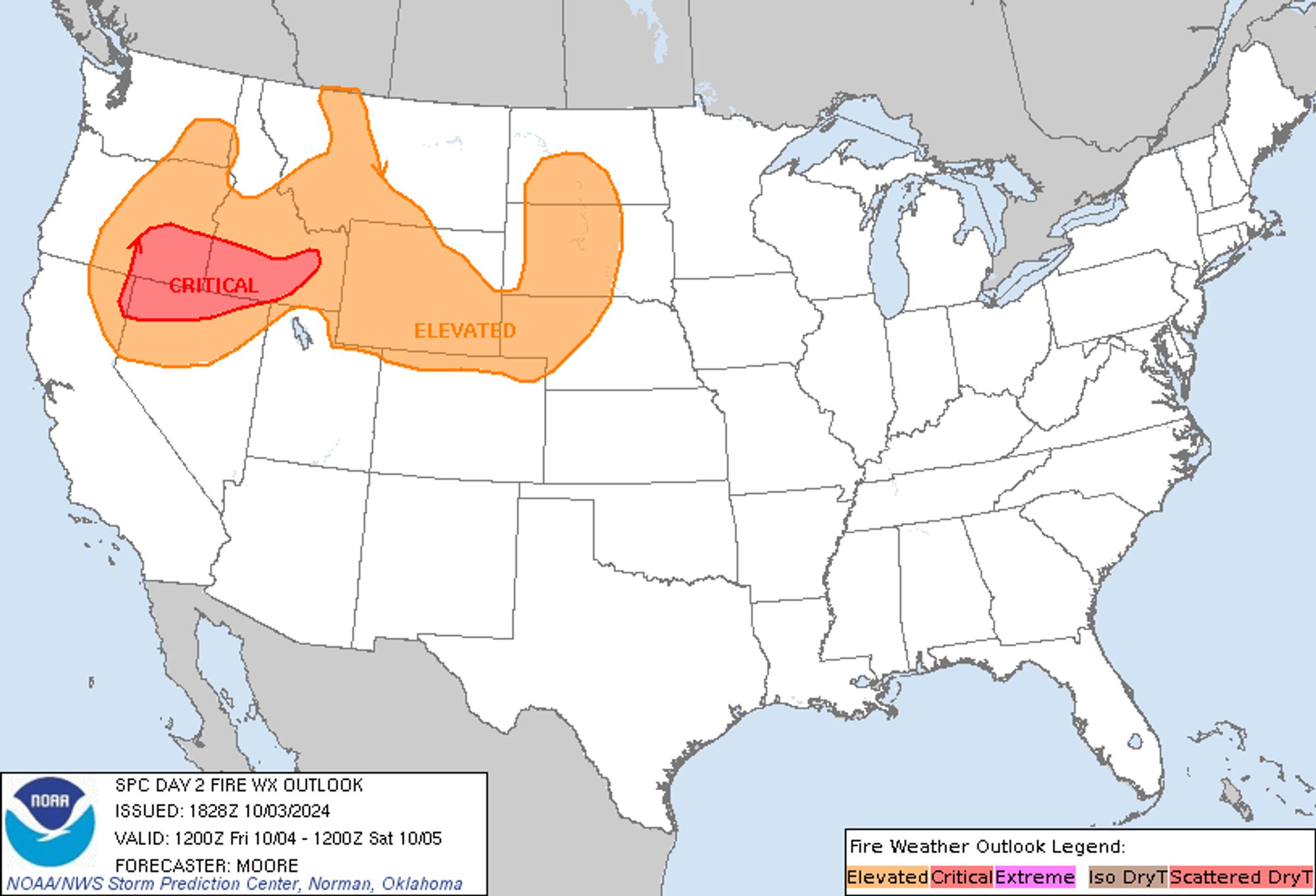
SPC Day 2 Fire Weather Outlook posted at Thu, 03 Oct 2024 18:29:27 +0000 🔥CRITICAL FIRE WEATHER AREA FOR PARTS OF THE NORTHERN GREAT BASIN AND SOUTHEASTERN PACIFIC NORTHWEST🔥 Additional Details Here.


Day 2 Fire Weather Outlook  
NWS Storm Prediction Center Norman OK
0128 PM CDT Thu Oct 03 2024

Valid 041200Z - 051200Z

...CRITICAL FIRE WEATHER AREA FOR PARTS OF THE NORTHERN GREAT BASIN
AND SOUTHEASTERN PACIFIC NORTHWEST...

The primary adjustment for this forecast update was a consolidation
of the separate Elevated risk areas. Latest forecast guidance
continues to trend towards increasing winds across much of the
Pacific Northwest and northern Rockies. As such, dry and windy
downslope conditions are expected in the lee of most prominent
mountain ranges across the region. While some gaps in dry/windy
conditions are anticipated, the majority of the northern Rockies
will see the potential for elevated to critical fire weather
conditions.

Consideration was given for additional Critical risk areas across
southwest MT and central WY, but the strongest winds will likely
remain somewhat confined to the lee of terrain features, casting
some uncertainty into the coverage of critical conditions. An
expansion of the Elevated risk area across central to eastern MT was
also considered as the cold front pushes east overnight. While drier
solutions hint that elevated conditions are possible in the
immediate wake of the front, ensemble guidance shows muted
probabilities (30-40%) for reaching elevated criteria (likely due to
the influence of nocturnal cooling). Trends will continue to be
monitored for additional risk highlights across these regions.

..Moore.. 10/03/2024

.PREV DISCUSSION... /ISSUED 0221 AM CDT Thu Oct 03 2024/

...Synopsis...
A strong mid-level trough will approach and eventually overspread
the Pacific Northwest on Friday. Ahead of this trough, a strong
surface cyclone will develop in Alberta, which will result in a
tightening surface pressure gradient across much of the Pacific
Northwest and the northern Rockies. In addition, 60+ mph of
mid-level flow will move across the Northwest and northern Great
Basin. This stronger mid-level flow will overspread a deeply mixed
airmass across southeast Oregon and northern Nevada and vicinity,
which will result in even stronger winds across this region.
Sustained winds of 25 to 30 mph are expected with relative humidity
ranging from 15 percent to 25 percent. Given the critically dry
nature of the fuels in this area, a Critical delineation was
warranted. 

As the pressure gradient tightens across the northern Rockies and
northern Plains, strong winds are expected to develop both across
southern Wyoming and from the Nebraska Panhandle northward across
the western Dakotas. Single-digit relative humidities are forecast
across southern Wyoming with 15 to 25 percent relative humidity in
the Plains. An Elevated delineation is warranted for both areas, and
if winds trend stronger in Wyoming or relative humidity drier in the
Plains, a Critical area may also need to be considered in these
areas in later outlooks.

...Please see www.spc.noaa.gov/fire for graphic product...
Day 2 Fire Weather Outlook Image
0
RFkazrushfox.bsky.social

October Drawing Marathon #2 - Fiona the Fox with pumpkins🎃 P.S. If you want to order one of the marathon drawings with your character, write to me... Prev: bsky.app/profile/kazr...#furry#furryart#cartoon#cartoonart#art#OC#sexy#female#Fox#pumpkin#OctoberDrawingMarathon#RushFoxStudios

0
faviator.bsky.social

Yeah. I’m definitely asking for new anxiety meds. This job and what happened yesterday made me realize that at work I have nearly crippling anxiety. My prev psych just kept saying what I was on shld be helping, but my new 1 is so much better. The hydroxyzine was making me dead in my bones

2