BLUE
Jespnjockjams.bsky.social

Oh right we're out of the eclipse cycle and my little riddles-three prediction about a future event did not come true. A bunch of horrible things happened, but not my thing!! Even if it still does sometime in the next month I must take the L. Thank god I finally proved astrology is fake at least

0
MJkainrivers.bsky.social

The second "prediction" is that if replaced with atheism, then everyone will become more rational People are rational without that.

1
Cchrisna.bsky.social

For this prediction to be right, the Rams would need to score 10 unanswered exact points. Won't happen. My numbers are bad. I'm an idiot.

0
SFspc-fire.nws-bot.us

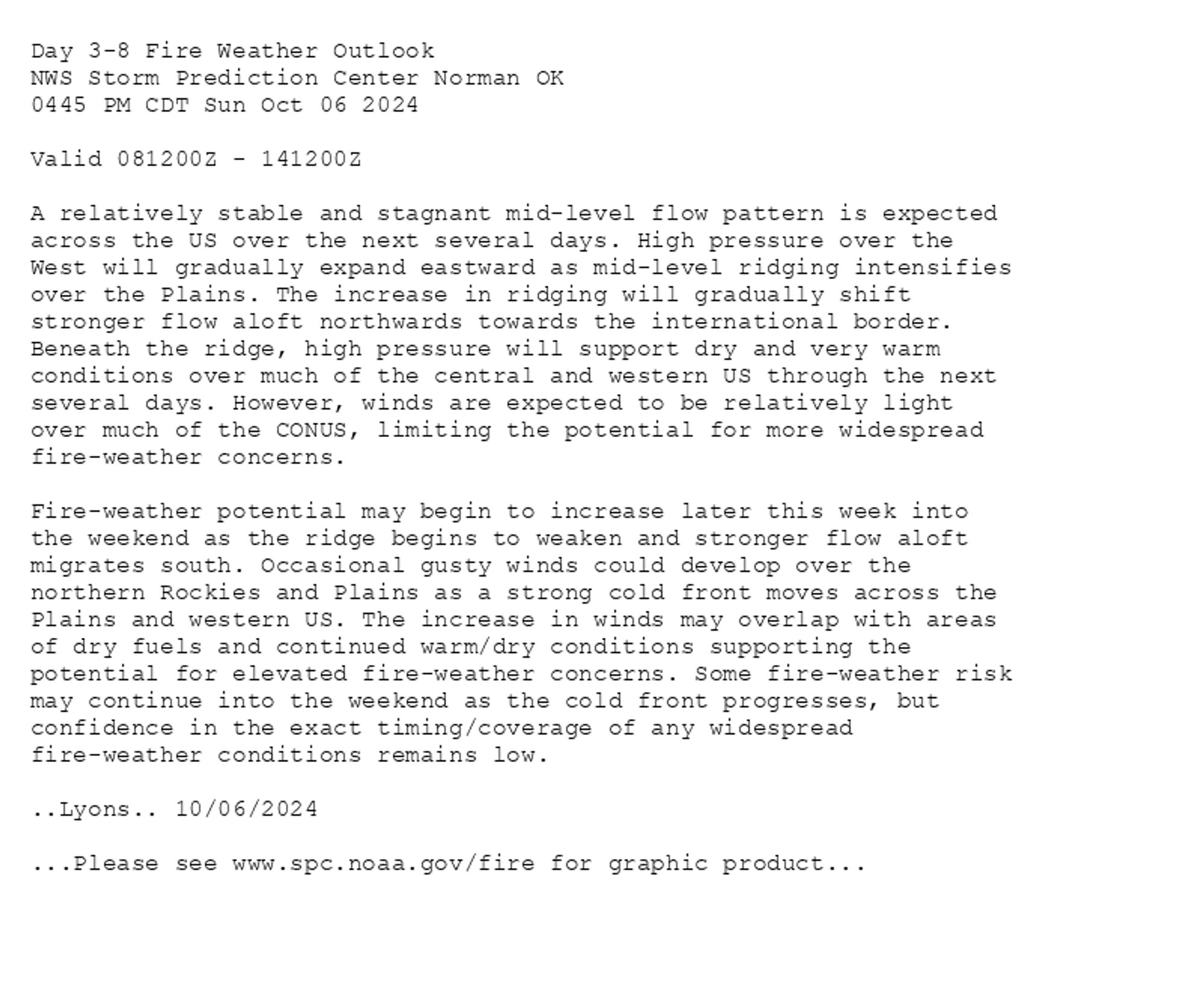
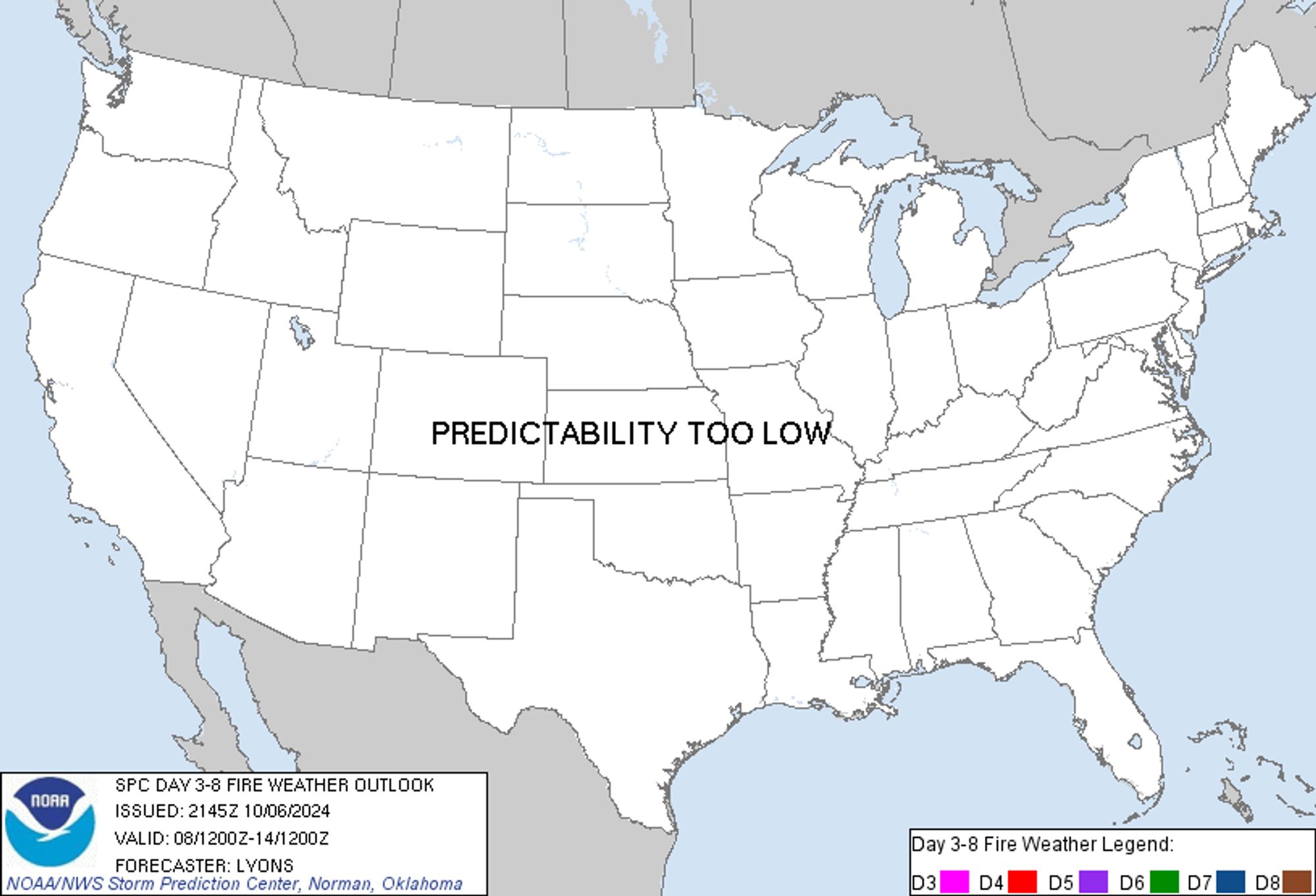
SPC Day 3-8 Fire Weather Outlook posted at Sun, 06 Oct 2024 21:50:17 +0000 🔥Please see www.spc.noaa.gov/fire for graphic product🔥 Additional Details Here.


Day 3-8 Fire Weather Outlook  
NWS Storm Prediction Center Norman OK
0445 PM CDT Sun Oct 06 2024

Valid 081200Z - 141200Z

A relatively stable and stagnant mid-level flow pattern is expected
across the US over the next several days. High pressure over the
West will gradually expand eastward as mid-level ridging intensifies
over the Plains. The increase in ridging will gradually shift
stronger flow aloft northwards towards the international border.
Beneath the ridge, high pressure will support dry and very warm
conditions over much of the central and western US through the next
several days. However, winds are expected to be relatively light
over much of the CONUS, limiting the potential for more widespread
fire-weather concerns.

Fire-weather potential may begin to increase later this week into
the weekend as the ridge begins to weaken and stronger flow aloft
migrates south. Occasional gusty winds could develop over the
northern Rockies and Plains as a strong cold front moves across the
Plains and western US. The increase in winds may overlap with areas
of dry fuels and continued warm/dry conditions supporting the
potential for elevated fire-weather concerns. Some fire-weather risk
may continue into the weekend as the cold front progresses, but
confidence in the exact timing/coverage of any widespread
fire-weather conditions remains low.

..Lyons.. 10/06/2024

...Please see www.spc.noaa.gov/fire for graphic product...
Day 3-8 Fire Weather Outlook Image
0
Ssaskya.com

Here comes the next hurricane. While it *is* trekking along in my direction, if the current early predictions stay accurate, it will skirt us again. I sure hope it is gentle to those people who are still getting themselves back together from Helene. #hurricanemilton

A zoomed in image of a map with the edge of a hurricane prediction zone on the right bottom side. There's a blue circle on the left top side that indicates my position.
1
Cchrisna.bsky.social

Prediction: Packers will win 24-23. The Rams' missed extra point will damn them. Damn them to hell!

0
JGjongar.bsky.social

Prediction: Bill Belichick to coach the Bengals next season.

0
STspc-storms.nws-bot.us

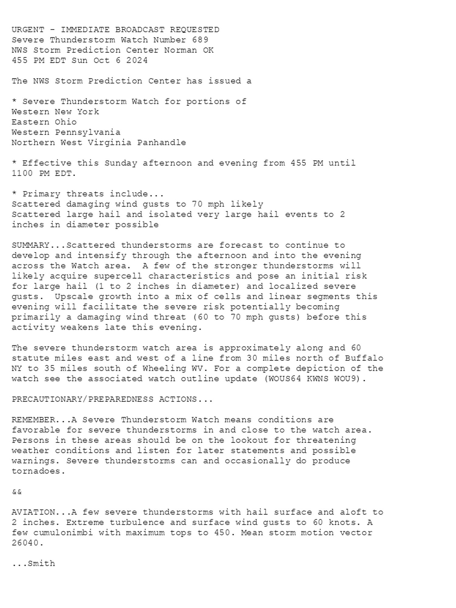
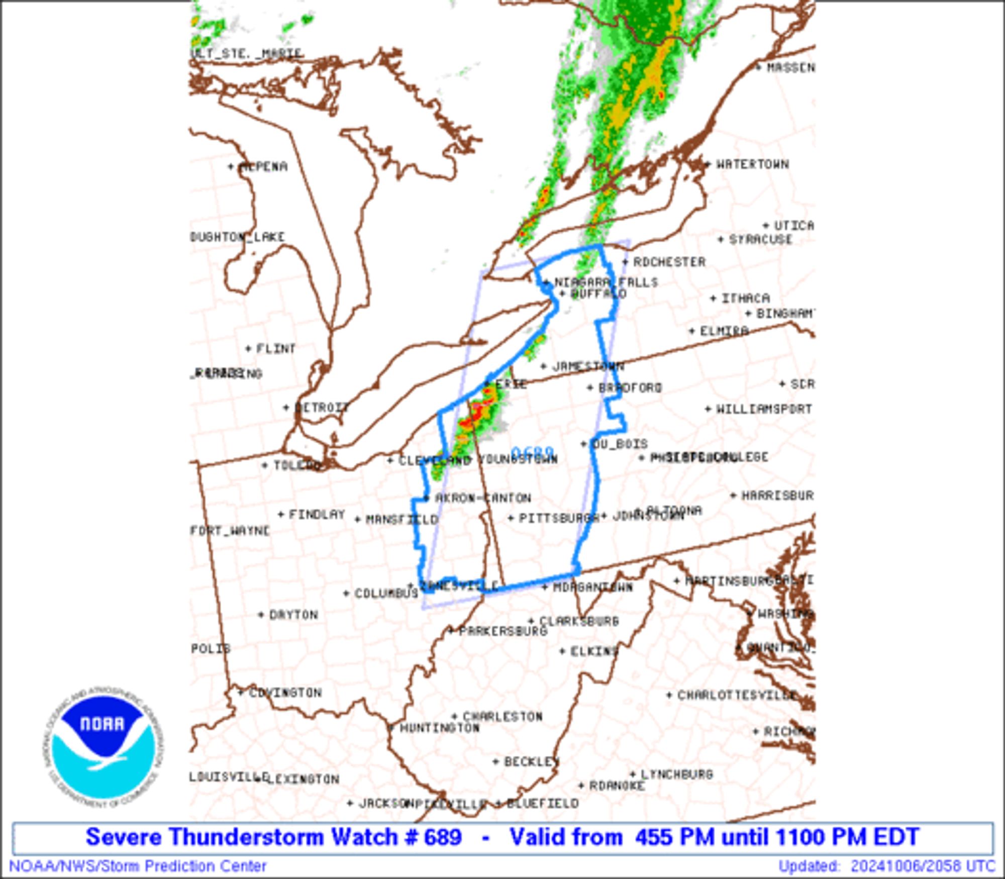
SPC Severe Thunderstorm Watch 689 ⛈️ Scattered damaging wind gusts to 70 mph likely Scattered large hail and isolated very large hail events to 2 inches in diameter possible SUMMARY🌪️ Additional Details Here.


URGENT - IMMEDIATE BROADCAST REQUESTED
Severe Thunderstorm Watch Number 689
NWS Storm Prediction Center Norman OK
455 PM EDT Sun Oct 6 2024

The NWS Storm Prediction Center has issued a

* Severe Thunderstorm Watch for portions of 
  Western New York
  Eastern Ohio
  Western Pennsylvania
  Northern West Virginia Panhandle

* Effective this Sunday afternoon and evening from 455 PM until
  1100 PM EDT.

* Primary threats include...
  Scattered damaging wind gusts to 70 mph likely
  Scattered large hail and isolated very large hail events to 2
    inches in diameter possible

SUMMARY...Scattered thunderstorms are forecast to continue to
develop and intensify through the afternoon and into the evening
across the Watch area.  A few of the stronger thunderstorms will
likely acquire supercell characteristics and pose an initial risk
for large hail (1 to 2 inches in diameter) and localized severe
gusts.  Upscale growth into a mix of cells and linear segments this
evening will facilitate the severe risk potentially becoming
primarily a damaging wind threat (60 to 70 mph gusts) before this
activity weakens late this evening.

The severe thunderstorm watch area is approximately along and 60
statute miles east and west of a line from 30 miles north of Buffalo
NY to 35 miles south of Wheeling WV. For a complete depiction of the
watch see the associated watch outline update (WOUS64 KWNS WOU9).

PRECAUTIONARY/PREPAREDNESS ACTIONS...

REMEMBER...A Severe Thunderstorm Watch means conditions are
favorable for severe thunderstorms in and close to the watch area.
Persons in these areas should be on the lookout for threatening
weather conditions and listen for later statements and possible
warnings. Severe thunderstorms can and occasionally do produce
tornadoes.

&&

AVIATION...A few severe thunderstorms with hail surface and aloft to
2 inches. Extreme turbulence and surface wind gusts to 60 knots. A
few cumulonimbi with maximum tops to 450. Mean storm motion vector
26040.

...Smith
WW 0689 Image
0
AQangelapadron.bsky.social

Artober Day #5 - PLAID (A day late but hopefully a prediction of the future!) #scbwiartober2024#plaid#HarrisWalz2024#Election2024#kidlit#kidlitartpostcard#america#Vote2024#VoteBlue

0
RWryanwenslow.bsky.social

Oh! There’s a new Hunter X Hunter chapter in Shonen Jump today? Those don’t happen very often Can’t read it until later so I’m making my prediction now - I will come out of it declaring “I understood nothing they were talking about in this chapter”

0