BLUE
STspc-storms.nws-bot.us

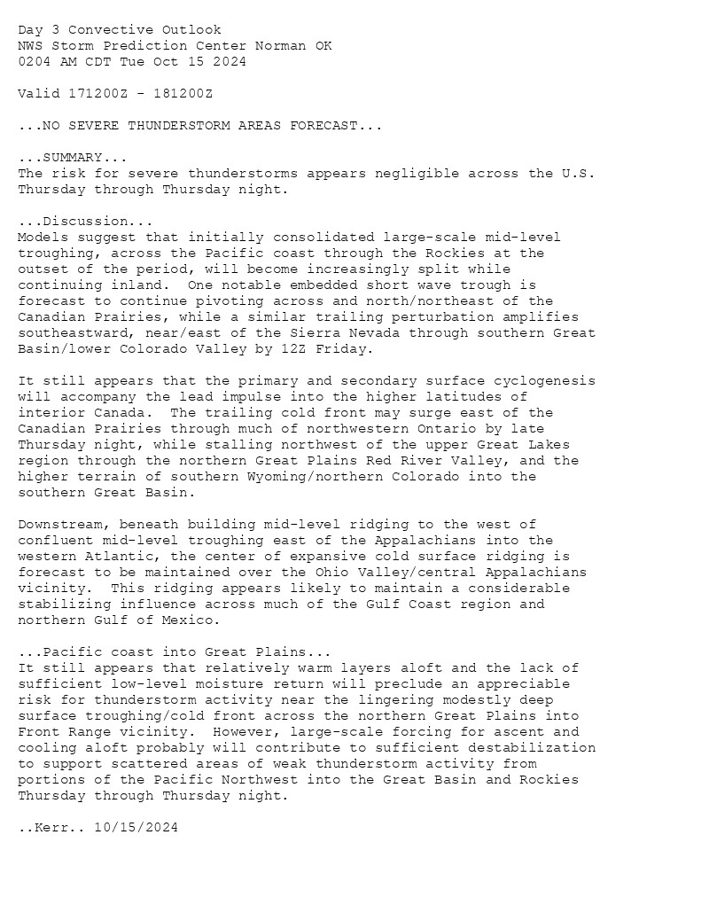
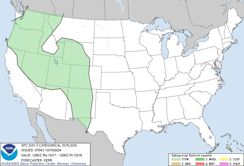
SPC Oct 15, 2024 0730 UTC Day 3 Severe Thunderstorm Outlook ⛈️NO SEVERE THUNDERSTORM AREAS FORECAST🌪️ Additional Details Here.


Day 3 Convective Outlook  
NWS Storm Prediction Center Norman OK
0204 AM CDT Tue Oct 15 2024

Valid 171200Z - 181200Z

...NO SEVERE THUNDERSTORM AREAS FORECAST...

...SUMMARY...
The risk for severe thunderstorms appears negligible across the U.S.
Thursday through Thursday night.

...Discussion...
Models suggest that initially consolidated large-scale mid-level
troughing, across the Pacific coast through the Rockies at the
outset of the period, will become increasingly split while
continuing inland.  One notable embedded short wave trough is
forecast to continue pivoting across and north/northeast of the
Canadian Prairies, while a similar trailing perturbation amplifies
southeastward, near/east of the Sierra Nevada through southern Great
Basin/lower Colorado Valley by 12Z Friday.

It still appears that the primary and secondary surface cyclogenesis
will accompany the lead impulse into the higher latitudes of
interior Canada.  The trailing cold front may surge east of the
Canadian Prairies through much of northwestern Ontario by late
Thursday night, while stalling northwest of the upper Great Lakes
region through the northern Great Plains Red River Valley, and the
higher terrain of southern Wyoming/northern Colorado into the
southern Great Basin.

Downstream, beneath building mid-level ridging to the west of
confluent mid-level troughing east of the Appalachians into the
western Atlantic, the center of expansive cold surface ridging is
forecast to be maintained over the Ohio Valley/central Appalachians
vicinity.  This ridging appears likely to maintain a considerable
stabilizing influence across much of the Gulf Coast region and
northern Gulf of Mexico.

...Pacific coast into Great Plains...
It still appears that relatively warm layers aloft and the lack of
sufficient low-level moisture return will preclude an appreciable
risk for thunderstorm activity near the lingering modestly deep
surface troughing/cold front across the northern Great Plains into
Front Range vicinity.  However, large-scale forcing for ascent and
cooling aloft probably will contribute to sufficient destabilization
to support scattered areas of weak thunderstorm activity from
portions of the Pacific Northwest into the Great Basin and Rockies
Thursday through Thursday night.

..Kerr.. 10/15/2024
Day 3 Outlook Image
0
STspc-storms.nws-bot.us

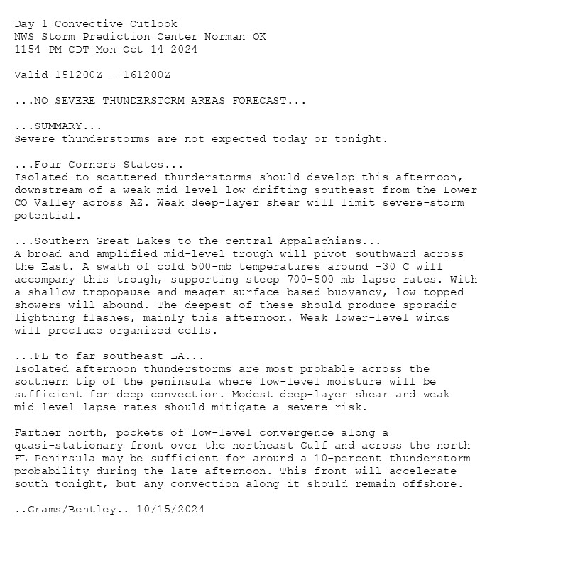
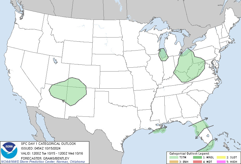
SPC Oct 15, 2024 0600 UTC Day 1 Convective Outlook ⛈️NO SEVERE THUNDERSTORM AREAS FORECAST🌪️ Additional Details Here.


Day 1 Convective Outlook  
NWS Storm Prediction Center Norman OK
1154 PM CDT Mon Oct 14 2024

Valid 151200Z - 161200Z

...NO SEVERE THUNDERSTORM AREAS FORECAST...

...SUMMARY...
Severe thunderstorms are not expected today or tonight.

...Four Corners States...
Isolated to scattered thunderstorms should develop this afternoon,
downstream of a weak mid-level low drifting southeast from the Lower
CO Valley across AZ. Weak deep-layer shear will limit severe-storm
potential. 

...Southern Great Lakes to the central Appalachians...
A broad and amplified mid-level trough will pivot southward across
the East. A swath of cold 500-mb temperatures around -30 C will
accompany this trough, supporting steep 700-500 mb lapse rates. With
a shallow tropopause and meager surface-based buoyancy, low-topped
showers will abound. The deepest of these should produce sporadic
lightning flashes, mainly this afternoon. Weak lower-level winds
will preclude organized cells.

...FL to far southeast LA...
Isolated afternoon thunderstorms are most probable across the
southern tip of the peninsula where low-level moisture will be
sufficient for deep convection. Modest deep-layer shear and weak
mid-level lapse rates should mitigate a severe risk.

Farther north, pockets of low-level convergence along a
quasi-stationary front over the northeast Gulf and across the north
FL Peninsula may be sufficient for around a 10-percent thunderstorm
probability during the late afternoon. This front will accelerate
south tonight, but any convection along it should remain offshore.

..Grams/Bentley.. 10/15/2024
Day 1 Outlook Image
0
WP2facedjanus7927.bsky.social

If you would instead like to hiss and spit at me, you are proving my prior belief that people love to use Appalachians and Natives as props to shame other white people but do not give a single fuck about us and what we want right.

1
Ppandaramble.bsky.social

The one is a reality show about celebrities competing in various challenges and the other is them trekking through Appalachians, more educational.

0
STspc-storms.nws-bot.us

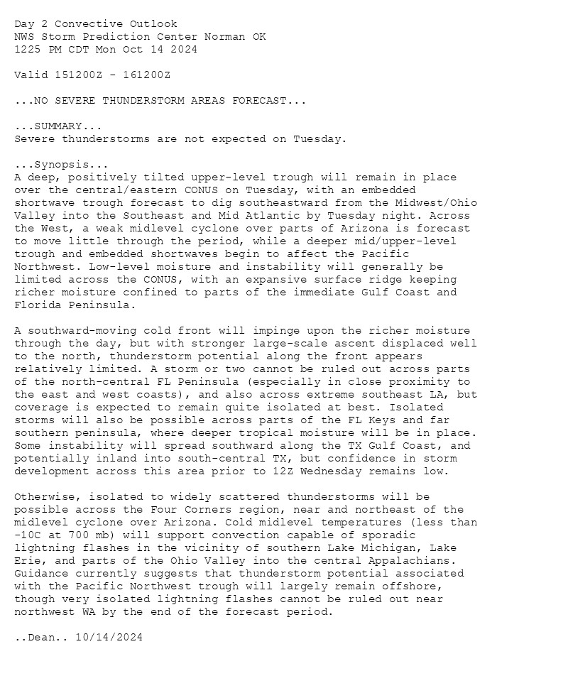
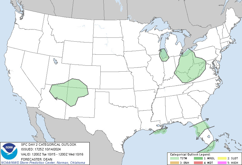
SPC Oct 14, 2024 1730 UTC Day 2 Convective Outlook ⛈️NO SEVERE THUNDERSTORM AREAS FORECAST🌪️ Additional Details Here.


Day 2 Convective Outlook  
NWS Storm Prediction Center Norman OK
1225 PM CDT Mon Oct 14 2024

Valid 151200Z - 161200Z

...NO SEVERE THUNDERSTORM AREAS FORECAST...

...SUMMARY...
Severe thunderstorms are not expected on Tuesday.

...Synopsis...
A deep, positively tilted upper-level trough will remain in place
over the central/eastern CONUS on Tuesday, with an embedded
shortwave trough forecast to dig southeastward from the Midwest/Ohio
Valley into the Southeast and Mid Atlantic by Tuesday night. Across
the West, a weak midlevel cyclone over parts of Arizona is forecast
to move little through the period, while a deeper mid/upper-level
trough and embedded shortwaves begin to affect the Pacific
Northwest. Low-level moisture and instability will generally be
limited across the CONUS, with an expansive surface ridge keeping
richer moisture confined to parts of the immediate Gulf Coast and
Florida Peninsula. 

A southward-moving cold front will impinge upon the richer moisture
through the day, but with stronger large-scale ascent displaced well
to the north, thunderstorm potential along the front appears
relatively limited. A storm or two cannot be ruled out across parts
of the north-central FL Peninsula (especially in close proximity to
the east and west coasts), and also across extreme southeast LA, but
coverage is expected to remain quite isolated at best. Isolated
storms will also be possible across parts of the FL Keys and far
southern peninsula, where deeper tropical moisture will be in place.
Some instability will spread southward along the TX Gulf Coast, and
potentially inland into south-central TX, but confidence in storm
development across this area prior to 12Z Wednesday remains low.  

Otherwise, isolated to widely scattered thunderstorms will be
possible across the Four Corners region, near and northeast of the
midlevel cyclone over Arizona. Cold midlevel temperatures (less than
-10C at 700 mb) will support convection capable of sporadic
lightning flashes in the vicinity of southern Lake Michigan, Lake
Erie, and parts of the Ohio Valley into the central Appalachians.
Guidance currently suggests that thunderstorm potential associated
with the Pacific Northwest trough will largely remain offshore,
though very isolated lightning flashes cannot be ruled out near
northwest WA by the end of the forecast period.

..Dean.. 10/14/2024
Day 2 Outlook Image
0
cloudyobsession.com

You'll have to deal with my accent mishmash because there's a good amount of Foothills of the Appalachians but it's also roughly 30-40% Midwest Lite The joy of growing up all over the place, no one has any clue where I'm from X3;;

1
STspc-storms.nws-bot.us

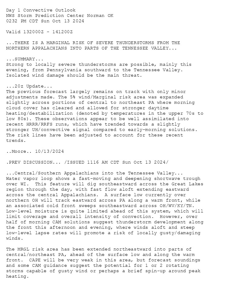
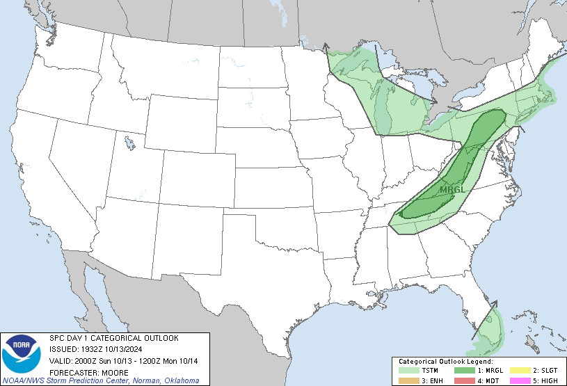
SPC Oct 13, 2024 2000 UTC Day 1 Convective Outlook ⛈️THERE IS A MARGINAL RISK OF SEVERE THUNDERSTORMS FROM THE NORTHERN APPALACHIANS INTO PARTS OF THE TENNESSEE VALLEY🌪️ Additional Details Here.


Day 1 Convective Outlook  
NWS Storm Prediction Center Norman OK
0232 PM CDT Sun Oct 13 2024

Valid 132000Z - 141200Z

...THERE IS A MARGINAL RISK OF SEVERE THUNDERSTORMS FROM THE
NORTHERN APPALACHIANS INTO PARTS OF THE TENNESSEE VALLEY...

...SUMMARY...
Strong to locally severe thunderstorms are possible, mainly this
evening, from Pennsylvania southward to the Tennessee Valley.
Isolated wind damage should be the main threat.

...20z Update...
The previous forecast largely remains on track with only minor
adjustments made. The 5% wind/Marginal risk area was expanded
slightly across portions of central to northeast PA where morning
cloud cover has cleared and allowed for stronger daytime
heating/destabilization (denoted by temperatures in the upper 70s to
low 80s). These observations appear to be well assimilated into
recent HRRR/RRFS runs, which have trended towards a slightly
stronger UH/convective signal compared to early-morning solutions.
The risk lines have been adjusted to account for these recent
trends.

..Moore.. 10/13/2024

.PREV DISCUSSION... /ISSUED 1116 AM CDT Sun Oct 13 2024/

...Central/Southern Appalachians into the Tennessee Valley...
Water vapor loop shows a fast-moving and deepening shortwave trough
over WI.  This feature will dig southeastward across the Great Lakes
region through the day, with fast flow aloft extending eastward
across the central Appalachians.  A surface low currently over
northern OH will track eastward across PA along a warm front, while
an associated cold front sweeps southeastward across OH/WV/KY/TN. 
Low-level moisture is quite limited ahead of this system, which will
limit coverage and overall intensity of convection.  However, over
half of morning CAM solutions suggest thunderstorm development along
the front this afternoon and evening, where winds aloft and steep
low-level lapse rates will promote a risk of locally gusty/damaging
winds.  

The MRGL risk area has been extended northeastward into parts of
central/northeast PA, ahead of the surface low and along the warm
front.  CAPE will be very weak in this area, but forecast soundings
and some CAM guidance suggest the potential for 1 or 2 rotating
storms capable of gusty wind or perhaps a brief spin-up around peak
heating.
Day 1 Outlook Image
0
STspc-storms.nws-bot.us

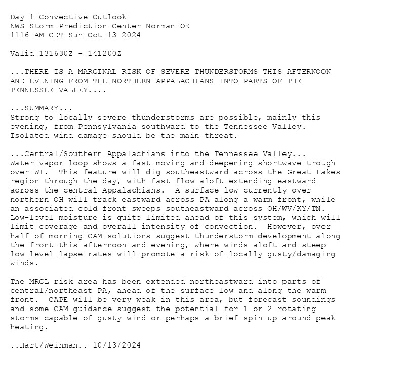
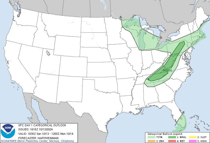
SPC Oct 13, 2024 1630 UTC Day 1 Convective Outlook ⛈️THERE IS A MARGINAL RISK OF SEVERE THUNDERSTORMS THIS AFTERNOON AND EVENING FROM THE NORTHERN APPALACHIANS INTO PARTS OF THE TENNESSEE VALLEY🌪️ Additional Details Here.


Day 1 Convective Outlook  
NWS Storm Prediction Center Norman OK
1116 AM CDT Sun Oct 13 2024

Valid 131630Z - 141200Z

...THERE IS A MARGINAL RISK OF SEVERE THUNDERSTORMS THIS AFTERNOON
AND EVENING FROM THE NORTHERN APPALACHIANS INTO PARTS OF THE
TENNESSEE VALLEY....

...SUMMARY...
Strong to locally severe thunderstorms are possible, mainly this
evening, from Pennsylvania southward to the Tennessee Valley.
Isolated wind damage should be the main threat.

...Central/Southern Appalachians into the Tennessee Valley...
Water vapor loop shows a fast-moving and deepening shortwave trough
over WI.  This feature will dig southeastward across the Great Lakes
region through the day, with fast flow aloft extending eastward
across the central Appalachians.  A surface low currently over
northern OH will track eastward across PA along a warm front, while
an associated cold front sweeps southeastward across OH/WV/KY/TN. 
Low-level moisture is quite limited ahead of this system, which will
limit coverage and overall intensity of convection.  However, over
half of morning CAM solutions suggest thunderstorm development along
the front this afternoon and evening, where winds aloft and steep
low-level lapse rates will promote a risk of locally gusty/damaging
winds.  

The MRGL risk area has been extended northeastward into parts of
central/northeast PA, ahead of the surface low and along the warm
front.  CAPE will be very weak in this area, but forecast soundings
and some CAM guidance suggest the potential for 1 or 2 rotating
storms capable of gusty wind or perhaps a brief spin-up around peak
heating.

..Hart/Weinman.. 10/13/2024
Day 1 Outlook Image
0
LMcopacetic-vibe.bsky.social

⚠️ Details in ALT Text ⚠️ Pay attention to local meteorologists and reliable weather apps if you live in a colored area on the top map. Stay updated on the weather in your area and be prepared with a plan for severe weather.  #WeatherAwareDay#weather#wx#SPC#WeatherAware#SevereWeather

Strong to locally severe thunderstorms are possible, mainly this evening, across parts of the central/southern Appalachians and Tennessee Valley. Isolated wind damage and marginally severe hail should be the main threats. Please stay weather aware. #WeatherAwareDay #weather #wx #SPC #SevereWeather  
Strong Storm Impacting Alaska; Heavy Rain Continues in Southeast Florida
A strong storm will continue to bring impacts to Alaska, including moderate to heavy rain from the north Gulf coast into the Panhandle, heavy snowfall along the coastal mountains and the Interior, and strong winds along the coast. Heavy rainfall and localized flash flooding will continue in southeast Florida and the Keys. Strong thunderstorms are possible in the central Appalachians.
1
STspc-storms.nws-bot.us

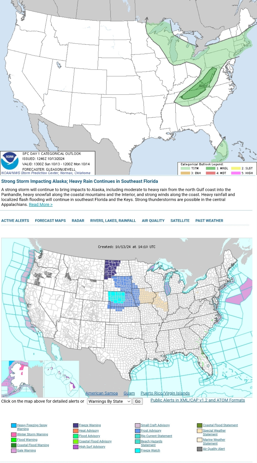
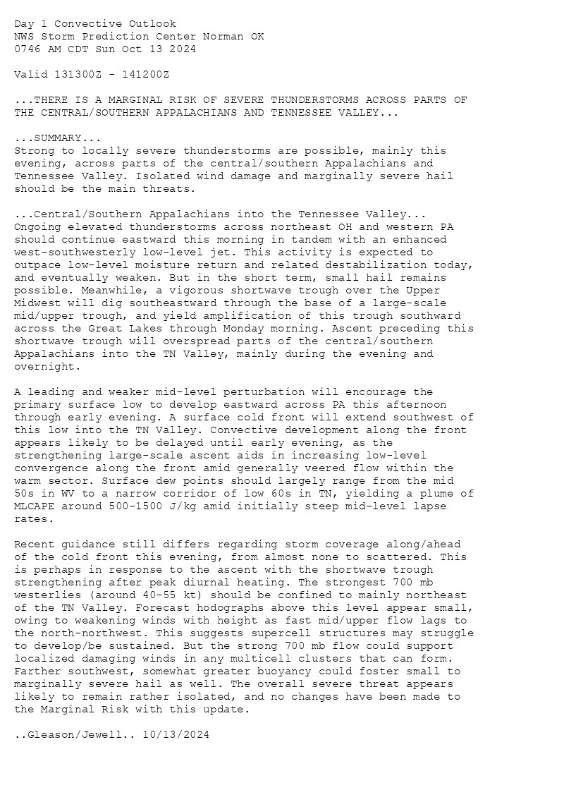
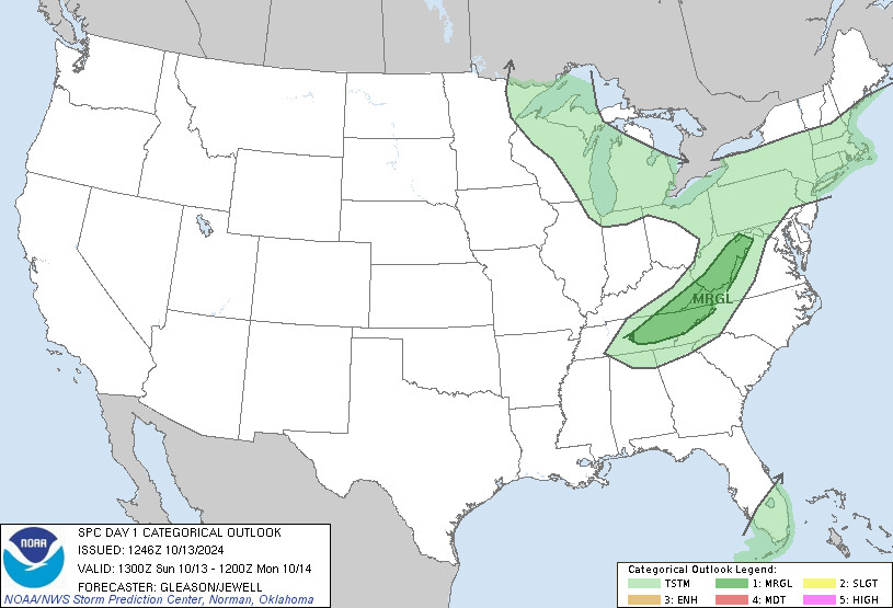
SPC Oct 13, 2024 1300 UTC Day 1 Convective Outlook ⛈️THERE IS A MARGINAL RISK OF SEVERE THUNDERSTORMS ACROSS PARTS OF THE CENTRAL/SOUTHERN APPALACHIANS AND TENNESSEE VALLEY🌪️ Additional Details Here.


Day 1 Convective Outlook  
NWS Storm Prediction Center Norman OK
0746 AM CDT Sun Oct 13 2024

Valid 131300Z - 141200Z

...THERE IS A MARGINAL RISK OF SEVERE THUNDERSTORMS ACROSS PARTS OF
THE CENTRAL/SOUTHERN APPALACHIANS AND TENNESSEE VALLEY...

...SUMMARY...
Strong to locally severe thunderstorms are possible, mainly this
evening, across parts of the central/southern Appalachians and
Tennessee Valley. Isolated wind damage and marginally severe hail
should be the main threats.

...Central/Southern Appalachians into the Tennessee Valley...
Ongoing elevated thunderstorms across northeast OH and western PA
should continue eastward this morning in tandem with an enhanced
west-southwesterly low-level jet. This activity is expected to
outpace low-level moisture return and related destabilization today,
and eventually weaken. But in the short term, small hail remains
possible. Meanwhile, a vigorous shortwave trough over the Upper
Midwest will dig southeastward through the base of a large-scale
mid/upper trough, and yield amplification of this trough southward
across the Great Lakes through Monday morning. Ascent preceding this
shortwave trough will overspread parts of the central/southern
Appalachians into the TN Valley, mainly during the evening and
overnight.

A leading and weaker mid-level perturbation will encourage the
primary surface low to develop eastward across PA this afternoon
through early evening. A surface cold front will extend southwest of
this low into the TN Valley. Convective development along the front
appears likely to be delayed until early evening, as the
strengthening large-scale ascent aids in increasing low-level
convergence along the front amid generally veered flow within the
warm sector. Surface dew points should largely range from the mid
50s in WV to a narrow corridor of low 60s in TN, yielding a plume of
MLCAPE around 500-1500 J/kg amid initially steep mid-level lapse
rates.

Recent guidance still differs regarding storm coverage along/ahead
of the cold front this evening, from almost none to scattered. This
is perhaps in response to the ascent with the shortwave trough
strengthening after peak diurnal heating. The strongest 700 mb
westerlies (around 40-55 kt) should be confined to mainly northeast
of the TN Valley. Forecast hodographs above this level appear small,
owing to weakening winds with height as fast mid/upper flow lags to
the north-northwest. This suggests supercell structures may struggle
to develop/be sustained. But the strong 700 mb flow could support
localized damaging winds in any multicell clusters that can form.
Farther southwest, somewhat greater buoyancy could foster small to
marginally severe hail as well. The overall severe threat appears
likely to remain rather isolated, and no changes have been made to
the Marginal Risk with this update.

..Gleason/Jewell.. 10/13/2024
Day 1 Outlook Image
0